 view gallery view gallery S6.9 km S6.9 km
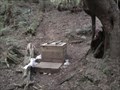
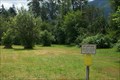
|   The Barclay Lake Toilet The Barclay Lake Toilet
in Outhouses This "facility" is located near Barclay lake. A sign with an arrow near the lake will lead the person of interest up a small trail to where you can see a clearing behind a large stump. posted by:  GeoBlank GeoBlank location: Washington date approved: 04/02/2011 last visited: never |
 view gallery view gallery SW9.7 km SW9.7 km
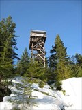
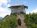
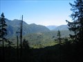
|  Heybrook Lookout Heybrook Lookout
in Look-Out Towers Heybrook Lookout, off US Hwy 2 near Mt. Index posted by:  Prying Pandora Prying Pandora location: Washington date approved: 02/27/2008 last visited: 12/06/2015 |
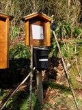 view gallery view gallerySW10.5 km |  Heybrook Lookout Trail Register Heybrook Lookout Trail Register
in Trail Registers Trail Register leading to Heybrook Lookout and Heybrook Ridge posted by: Prying Pandora location: Washington date approved: 03/01/2008 last visited: 03/10/2010 |
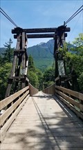 view gallery view gallerySW10.6 km |  Baring Wooden Suspension Bridge - Baring Wa Baring Wooden Suspension Bridge - Baring Wa
in Suspension Bridges A beautiful wooden one-lane suspension bridge crossing the Skykomish River in Baring, Washington. posted by: Winos_Seattle location: Washington date approved: 06/29/2020 last visited: never |
 view gallery view gallery E10.8 km E10.8 km
| Evergreen Mountain Lookout in Look-Out Towers A great hike for excellent views posted by:  E4han E4han location: Washington date approved: 07/03/2008 last visited: never |
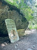
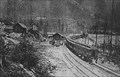 view gallery view galleryS11.7 km |  Wellington, Washington Wellington, Washington
in Ghost Towns Wellington, Washington is a ghost town on the old Great Northern Railway line, just off Stevens Pass Highway. posted by: Blue J Wenatchee location: Washington date approved: 07/08/2006 last visited: 09/02/2018 |
 view gallery view gallery W12.2 km W12.2 km
|  Bigfoot - Index, WA Bigfoot - Index, WA
in Outside Wooden Display Carvings Carved Bigfoot statue found outside the Espresso Chalet along Route 2. posted by: intolerable location: Washington date approved: 07/05/2008 last visited: 06/25/2020 |
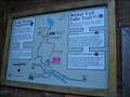 view gallery view galleryW13 km |  Lake Serene Trailhead Map Lake Serene Trailhead Map
in 'You Are Here' Maps A very interesting map posted by: riston2 location: Washington date approved: 09/21/2008 last visited: 02/18/2010 |
 view gallery view galleryW13 km |  Trail to Bridal Veil Falls and Lake Serene Trail to Bridal Veil Falls and Lake Serene
in Scenic Hikes Trail to Lake Serene off Hwy 2 near Index. posted by: Prying Pandora location: Washington date approved: 06/12/2007 last visited: 02/18/2010 |
 view gallery view gallerySW13.5 km | Bridal Falls Viewpoint in Scenic Overlooks An awesome view with an awesome water fall posted by: riston2 location: Washington date approved: 09/30/2008 last visited: 02/18/2010 |
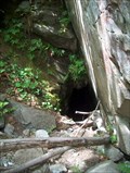 view gallery view gallerySW13.7 km | ") Lake Serene Mine Entrance Lake Serene Mine Entrance
in Cave Entrances (Artificial) An abandoned mine near the trail to Lake Serene posted by: Prying Pandora location: Washington date approved: 06/24/2007 last visited: 02/18/2010 |
 view gallery view galleryS15.4 km |  Skykomish Bridge- 1939 - Skykomish, WA Skykomish Bridge- 1939 - Skykomish, WA
in Bridge Date Stones and Plaques This bridge takes you from Highway 2 into Skykomish. posted by: gypsie2 location: Washington date approved: 08/29/2013 last visited: never |
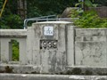
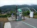 view gallery view galleryS15.4 km |  Skykomish Exit Charging Station, Hwy 2, WA Skykomish Exit Charging Station, Hwy 2, WA
in Electric Car Charging Stations Located on Highway 2 at the turn off to Skykomish. posted by: gypsie2 location: Washington date approved: 08/26/2013 last visited: 06/25/2020 |
 view gallery view gallery N15.6 km N15.6 km
| Monte Cristo, Washington in Ghost Towns Monte Cristo is a ghost town northwest of Monte Cristo Peak, in eastern Snohomish County in western Washington. posted by: giacaches location: Washington date approved: 07/24/2023 last visited: never |
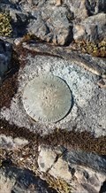
 view gallery view galleryN15.6 km |  TRIMBLE, Monte Cristo, WA TRIMBLE, Monte Cristo, WA
in U.S. Benchmarks USDA Forest Service Cadastral Survey disc in the ghost town of Monte Cristo. posted by: Prying Pandora location: Washington date approved: 07/07/2010 last visited: 07/05/2010 |
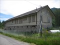 view gallery view galleryS15.6 km |  Skykomish Depot - Skykomish, Washington Skykomish Depot - Skykomish, Washington
in Train Stations/Depots This depot was built in 1894, shortly after the Great Northern Railway began running trains through Skykomish in 1893. Prior to 1894, a boxcar was used as the depot. posted by: Bluejacket01 location: Washington date approved: 01/03/2012 last visited: 06/25/2020 |
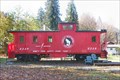 view gallery view galleryS15.9 km |  Great Northern Railway Caboose X228 Great Northern Railway Caboose X228
in Train Cabooses Great Northern Railway Caboose X228, located in Skykomish, Washington. posted by: HeyRob4449 location: Washington date approved: 11/11/2007 last visited: 07/25/2009 |
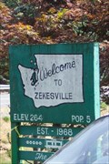 view gallery view galleryW17.5 km |  Zekesville, Washington - 264 feet Zekesville, Washington - 264 feet
in Elevation Signs Zekesville claims to be the state's smallest incorporated town, with 5 residents. It's sign claims an elevation of 264 ft. Found along Stevens Pass (Hwy 2) near the town of Index. posted by: Hikenutty location: Washington date approved: 03/25/2008 last visited: 05/23/2023 |
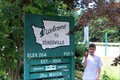 view gallery view galleryW17.5 km |  Zekesville Zekesville
in 'Z' Welcome Signs Zekesville is Washington's smallest incorporated town with only 5 residents! posted by: Hikenutty location: Washington date approved: 07/15/2006 last visited: 05/23/2023 |
 view gallery view galleryS17.5 km | Maloney Ridge Fire Lookout Site BM TS 17-25 - Skykomish WA in U.S. Benchmarks Washington State Highway Department Survey Marker on the Original Maloney Ridge Fire Tower Lookout site. posted by: Winos_Seattle location: Washington date approved: 06/26/2020 last visited: never |
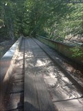 view gallery view galleryN18.3 km |  Plank road bridge - Snohomish county, WA Plank road bridge - Snohomish county, WA
in Plank Roads Old railway bridge on the trail to Monte Cristo, WA posted by: zeepia location: Washington date approved: 10/02/2023 last visited: never |
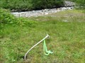
 view gallery view galleryN20 km |  Corner #4 of Mineral Survey No 388-B Corner #4 of Mineral Survey No 388-B
in Public Land Survey Marks A USFS Aluminum Cap Mon. as Corner # 4 of Mineral Survey No 388-B for the Augusta Millsite. posted by: stevebratz location: Washington date approved: 07/05/2011 last visited: never |
 view gallery view galleryW21.6 km |  Sultan Off Leash Area Sultan Off Leash Area
in Off-Leash Dog Areas Unfenced off-leash area next to Highway 2 (Stevens Pass) in the town of Sultan. posted by: Hikenutty location: Washington date approved: 07/15/2006 last visited: 07/20/2006 |
 view gallery view gallery SE21.9 km SE21.9 km
|  Tonga Ridge Area Blueberries Tonga Ridge Area Blueberries
in Berry Picking Wild berries near Snohomish. posted by: Ambrosia location: Washington date approved: 10/24/2006 last visited: 11/03/2006 |
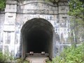 view gallery view gallerySE23.7 km |  Wellington Washington Wellington Washington
in Wikipedia Entries Wellington was on the West side of the original Cascade Tunnel just off the Stevens Pass Highway. posted by: Blue J Wenatchee location: Washington date approved: 11/06/2006 last visited: 10/31/2009 |
|