 view gallery view gallery S0 km S0 km
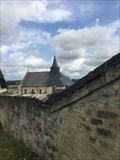
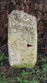
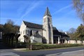
|   Repère geodésique - Eglise Candes-St-Martin - Centre Val de Loire - FRA Repère geodésique - Eglise Candes-St-Martin - Centre Val de Loire - FRA
in French Benchmarks Repère geodésique clocher de l'Eglise Candes St Martin posted by:  lynx36 lynx36 location: Centre-Val-de-Loire, France date approved: 07/28/2019 last visited: 07/27/2019 |
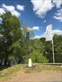
 view gallery view gallery NE0.3 km NE0.3 km
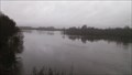
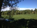
|  CONFLUENCE - Loire - Vienne - Candes Saint-Martin, Centre CONFLUENCE - Loire - Vienne - Candes Saint-Martin, Centre
in River Origins, Destinations and Confluences [FR]La confluence d'un fleuve, La Loire et d'une rivière La Vienne situés sur la commune de Candes Saint-Martin
[EN] The confluence of a river, the Loire and river Vienne located in the town of Candes Saint Martin. posted by: Tromel location: Centre-Val-de-Loire, France date approved: 02/20/2018 last visited: 06/21/2015 |
 view gallery view gallery NW1.4 km NW1.4 km
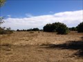
|  Parc Regional Loire Anjou Touraine - France Parc Regional Loire Anjou Touraine - France
in State/Provincial Parks la maison du parc vous guidera pour la visite du parc. posted by: sara et gege location: Centre-Val-de-Loire, France date approved: 05/14/2015 last visited: 06/06/2021 |
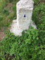 view gallery view galleryNE1.8 km |  Borne directionnelle D st M - Chouzé sur Loire - France Borne directionnelle D st M - Chouzé sur Loire - France
in European Historic Survey Stones, Monuments and Benchmarks Cette borne directionnelle est située sur le hameau La boire du chêne à Chouzé sur Loire.
This directional terminal is located on the hamlet La boire du chêne at Chouzé sur Loire. posted by: Alfouine location: Centre-Val-de-Loire, France date approved: 06/17/2017 last visited: never |
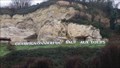
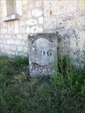 view gallery view galleryNE2.1 km | Borne repère n°496 (Savigny-en-Véron, Centre, France) in French Benchmarks Cette borne kilométrique n°496 se trouve au PK 198,70 sur la commune de Savigny-en-Véron posted by: LeBourguignon location: Centre-Val-de-Loire, France date approved: 09/09/2013 last visited: 09/08/2013 |
 view gallery view gallery SW2.1 km SW2.1 km
|  Centre/Pays de Loire/Poitou-Charentes Intersection point - France Centre/Pays de Loire/Poitou-Charentes Intersection point - France
in Public Land Survey Marks [F] Cette cippe est située à l'intersection des communes de Candes-Saint-Martin, de Fontevraud et de Montsoreau. [E] This tripoint (cippus) is located at the intersection of the municipalities of Candes-Saint-Martin, Fontevraud and Montsoreau. posted by: Chickilim location: Centre-Val-de-Loire, France date approved: 02/13/2016 last visited: 06/06/2021 |
 view gallery view gallerySW2.1 km |  La Cippe des 3 Évêchés - Centre, Pays de Loire, Poitou-Charentes, France La Cippe des 3 Évêchés - Centre, Pays de Loire, Poitou-Charentes, France
in Tripoints and Multipoints [F] Cette cippe est située à l'intersection des communes de Candes-Saint-Martin, de Fontevraud et de Montsoreau.
[E] This tripoint (cippus) is located at the intersection of the municipalities of Candes-Saint-Martin, Fontevraud and Montsoreau. posted by: Chickilim location: Centre-Val-de-Loire, France date approved: 10/16/2015 last visited: 06/06/2021 |
 view gallery view galleryNE2.1 km |  Les oiseaux des bancs de sable de Loire (Savigny-en-Véron, Centre, France) Les oiseaux des bancs de sable de Loire (Savigny-en-Véron, Centre, France)
in Birdwatching Locations [FR] Iles & grèves de sable où se reproduisent plusieurs espèces d'oiseaux observables à 30m minimum.
[EN] Islands and strikes of sand where reproduce several species of birds observable in 30 meters minimum. posted by: LeBourguignon location: Centre-Val-de-Loire, France date approved: 09/09/2013 last visited: 03/10/2015 |
 view gallery view gallery E2.1 km E2.1 km
|  Les Pelouses sèches de Bertignolles (Savigny-en-Véron, Centre, France) Les Pelouses sèches de Bertignolles (Savigny-en-Véron, Centre, France)
in Public Access Lands FR] Le site des "Hauts de Bertignolles" est un milieu dunaire continental devenu rare en Europe.
[EN] The site of "Les Hauts de Bertignolles " is a continental dune environment become rare in Europe. posted by: LeBourguignon location: Centre-Val-de-Loire, France date approved: 09/08/2013 last visited: 10/02/2016 |
 view gallery view galleryNW2.3 km | Borne directionnelle D st M - Turquant, Centre in European Historic Survey Stones, Monuments and Benchmarks [FR] Cette borne directionnelle est située à Turquant et matérialise le parcours que les pèlerins doivent suivr pour se rendre en Espagne [EN] This benchmark is located in Turquant and is the sign of the way of the directoin of Spain. posted by: Tromel location: Pays de la Loire, France date approved: 03/08/2018 last visited: 03/08/2018 |
 view gallery view galleryNW2.3 km |  Borne directionnelle D st M - Turquant, Centre Borne directionnelle D st M - Turquant, Centre
in Hiking and walking trailheads [FR] Cette borne directionnelle est située à Turquant et matérialise le parcours que les pèlerins doivent suivr pour se rendre en Espagne [EN] This benchmark is located in Turquant and is the sign of the way of the directoin of Spain. posted by: Tromel location: Pays de la Loire, France date approved: 03/06/2018 last visited: 03/06/2018 |
 view gallery view galleryNW2.3 km | Borne directionnelle D st M - Turquant, Centre in French Benchmarks [FR] Cette borne directionnelle est située à Turquant et matérialise le parcours que les pèlerins doivent suivr pour se rendre en Espagne [EN] This benchmark is located in Turquant and is the sign of the way of the directoin of Spain. posted by: Tromel location: Pays de la Loire, France date approved: 02/16/2018 last visited: 02/17/2018 |
 view gallery view galleryNW2.3 km |  Champignonnière du saut aux loups - Turquant, Pays de Loire Champignonnière du saut aux loups - Turquant, Pays de Loire
in Letters on Hills [FR] Sur les côteaux de Saumur nous pouvons lire : Champignonnière du saut aux loups.
[EN] On the hills of Saumur we can read: Champignonnière du saut aux loups posted by: Tromel location: Pays de la Loire, France date approved: 02/15/2018 last visited: 02/02/2020 |
 view gallery view galleryNW2.4 km |  Pont JMW Turner- Varennes sur Loire,France Pont JMW Turner- Varennes sur Loire,France
in Truss Bridges a very nice bridge to cross the Loire.
un tres joli pont pour franchir la Loire. posted by: sara et gege location: Pays de la Loire, France date approved: 02/02/2020 last visited: 06/06/2021 |
 view gallery view galleryNW2.4 km |  Pont Varennes Montsoreau - Varennes sur Loire, France Pont Varennes Montsoreau - Varennes sur Loire, France
in Wikipedia Entries A very nice bridge to cross the Loire.
Un tres joli pont pour franchir la Loire. posted by: sara et gege location: Pays de la Loire, France date approved: 02/02/2020 last visited: 06/06/2021 |
 view gallery view galleryNW2.6 km | Pont de Montsoreau - Rive droite (Varennes-sur-Loire, Pays de la Loire, France) in French Benchmarks Ce repère cylindrique se trouve sur le piédroit de la culée rive droite. posted by: LeBourguignon location: Pays de la Loire, France date approved: 11/18/2017 last visited: never |
 view gallery view galleryE2.7 km |  Les ailes rabelaisiennes - Chinon - France Les ailes rabelaisiennes - Chinon - France
in Model Aircraft Fields Dans un environnement bucolique, un superbe plateau pour pratiquer l’aéromodélisme.
In a bucolic environment, a superb plateau for practicing aeromodelling. posted by: Alfouine location: Centre-Val-de-Loire, France date approved: 05/02/2017 last visited: never |
 view gallery view gallerySW2.9 km | 130 Av. des Roches à Fontevraud-L'abbaye (49590) in French Benchmarks Ce repère Bourdaloue se trouve au No130 de l'avenue des Roches, sur le mur de façade nord-ouest d'une maison, face à la route D947. posted by: Itamae location: Centre-Val-de-Loire, France date approved: 05/10/2013 last visited: 11/18/2017 |
 view gallery view gallery SE2.9 km SE2.9 km
|  Eglise Saint-Germain - Saint-Germain-sur-Vienne, France Eglise Saint-Germain - Saint-Germain-sur-Vienne, France
in Medieval Churches [EN] Romanesque church with a single nave dating from the 11th and 12th centuries, side tower of the 12th century, plantagenet choir of the 13th century.
[FR] Eglise romane à nef unique datant des XIe et XIIe siècles, clocher latéral du XIIe siècle, chœur plantagenêt du XIIIe siècle. posted by: pmaupin location: Centre-Val-de-Loire, France date approved: 11/11/2017 last visited: 07/27/2019 |
 view gallery view gallerySE2.9 km |  Eglise Saint-Germain - Saint-Germain-sur-Vienne, France Eglise Saint-Germain - Saint-Germain-sur-Vienne, France
in This Old Church [EN] Romanesque church with a single nave dating from the 11th and 12th centuries, side tower of the 12th century, plantagenet choir of the 13th century. [FR] Eglise romane à nef unique datant des XIe et XIIe siècles, clocher latéral du XIIe siècle, chœur plantagenêt du XIIIe siècle posted by: pmaupin location: Centre-Val-de-Loire, France date approved: 11/10/2017 last visited: 07/27/2019 |
 view gallery view gallerySE2.9 km | Eglise Saint-Germain - Saint-Germain-sur-Vienne, France in Roman Catholic Churches [EN] Romanesque church with a single nave dating from the 11th and 12th centuries, side tower of the 12th century, plantagenet choir of the 13th century. [FR] Eglise romane à nef unique datant des XIe et XIIe siècles, clocher latéral du XIIe siècle, chœur plantagenêt du XIIIe siècle. posted by: pmaupin location: Centre-Val-de-Loire, France date approved: 11/09/2017 last visited: 07/27/2019 |
 view gallery view gallerySE2.9 km |  Eglise Saint-Germain - Saint-Germain-sur-Vienne, France Eglise Saint-Germain - Saint-Germain-sur-Vienne, France
in Monuments Historiques Français [FR] Eglise romane à nef unique datant des XIe et XIIe siècles, clocher latéral du XIIe siècle, chœur plantagenêt du XIIIe siècle.
[EN] Romanesque church with a single nave dating from the 11th and 12th centuries, side tower of the 12th century, plantagenet choir of the 13th century. posted by: pmaupin location: Centre-Val-de-Loire, France date approved: 11/13/2017 last visited: 07/27/2019 |
 view gallery view gallerySE2.9 km |  Val de Loire - UNESCO 933 (St-Germain-sur-Vienne, Centre, France) Val de Loire - UNESCO 933 (St-Germain-sur-Vienne, Centre, France)
in World Heritage Sites [FR] La commune de St-Germain-sur-Vienne est inscrite au patrimoine de l'UNESCO dans le périmètre du Val de Loire.
[EN] The commune of St-Germain-sur-Vienne is registered in the UNESCO patrimony in the perimeter of the Loire Valley. posted by: LeBourguignon location: Centre-Val-de-Loire, France date approved: 05/02/2017 last visited: 07/27/2019 |
 view gallery view gallerySE2.9 km | Lieu-dit "Falèche" (Saint-Germain-sur-Vienne, Centre, France) in French Benchmarks Ce repère cylindrique se trouve sur le soubassement du mur de façade Nord-Est de l'Hôtel-Bar-Restaurant "Le Petit Saint-Germain", face route. posted by: LeBourguignon location: Centre-Val-de-Loire, France date approved: 11/03/2013 last visited: 07/27/2019 |
 view gallery view gallerySW3.2 km | 14 Av. des Roches à Fontevraud-L'abbaye (49590) in French Benchmarks Ce repère est situé au No14 de l'avenue des Roches sur le soubassement du mur de façade sid-ouest d'une maison, face à la route, à environ 13 cm au dessous de l'arête supérieure. posted by: Itamae location: Centre-Val-de-Loire, France date approved: 05/10/2013 last visited: 11/18/2017 |
|