 view gallery view gallery W8.4 km W8.4 km
|   Little Goose Dam - Washington Little Goose Dam - Washington
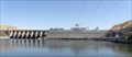
in Water Dams The Little Goose Dam on the Snake River near Starbuck, Washington. posted by:  Volcanoguy Volcanoguy location: Washington date approved: 04/30/2010 last visited: 09/01/2020 |
 view gallery view galleryW8.5 km |  Little Goose Dam Lock - Washington Little Goose Dam Lock - Washington
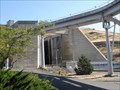
in Waterway Locks, Planes and Lifts The navigation lock at Little Goose Dam on the Snake River near Starbuck, Washington. posted by: Volcanoguy location: Washington date approved: 03/15/2010 last visited: 09/25/2009 |
 view gallery view galleryW8.5 km |  Little Goose Dam - Washington Little Goose Dam - Washington
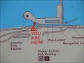
in 'You Are Here' Maps Map at Little Goose Dam on the Snake River in Washington. posted by: Volcanoguy location: Washington date approved: 03/14/2010 last visited: 09/25/2009 |
 view gallery view gallery SW9.3 km SW9.3 km
|  RZ1158 - USCGS C39 RESET, Washington RZ1158 - USCGS C39 RESET, Washington
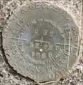
in U.S. Benchmarks US Coast & Geodetic Survey benchmark C39 RESET. posted by: Volcanoguy location: Washington date approved: 03/11/2010 last visited: 09/25/2009 |
 view gallery view galleryW14 km |  Texas Rapids, Washington Texas Rapids, Washington
in Lewis and Clark Trail This Lewis and Clark history sign is located at the Texas Rapids Boat Launch Area along the Little Goose Dam Road. posted by: Volcanoguy location: Washington date approved: 03/13/2010 last visited: 09/25/2009 |
 view gallery view galleryW14 km |  The Race to the Pacific The Race to the Pacific
in Washington Historical Markers This history sign is located at the Texas Rapids Boat Launch Area along the Little Goose Dam Road. posted by: Volcanoguy location: Washington date approved: 03/15/2010 last visited: 09/25/2009 |
 view gallery view gallerySW17.5 km |  Columbia County Fire District 1 Columbia County Fire District 1
in Firehouses Columbia County Fire District 2 firehouse in Starbuck, Washington. posted by: Volcanoguy location: Washington date approved: 03/14/2010 last visited: 09/25/2009 |
 view gallery view gallerySW17.5 km |  Siren - Starbuck, Washington Siren - Starbuck, Washington
in Outdoor Warning Sirens Warning Siren in Starbuck, Washington. posted by: Volcanoguy location: Washington date approved: 03/13/2010 last visited: 09/22/2009 |
 view gallery view gallerySW17.5 km |  Starbuck, WA. 99359 Starbuck, WA. 99359
in U.S. Post Offices The post office building in Starbuck, WA. posted by: Volcanoguy location: Washington date approved: 10/09/2009 last visited: 09/01/2020 |
 view gallery view gallerySW17.7 km |  Bank of Starbuck - Starbuck, WA Bank of Starbuck - Starbuck, WA
in Converted Bank Buildings A former bank in Starbuck, WA. posted by: saopaulo1 location: Washington date approved: 07/30/2017 last visited: never |
 view gallery view gallerySW17.7 km |  Starbuck - Washington Starbuck - Washington
in American Guide Series The small town of Starbuck, Washington. posted by: Volcanoguy location: Washington date approved: 03/15/2010 last visited: 09/25/2009 |
 view gallery view gallerySW17.7 km |  Columbia County Sheriff’s Dept. Sub-Station - Starbuck, Washington Columbia County Sheriff’s Dept. Sub-Station - Starbuck, Washington
in Police Stations Sub-station for the Columbia County Sheriff’s Dept. in Starbuck, Washington. posted by: Volcanoguy location: Washington date approved: 03/13/2010 last visited: 09/25/2009 |
 view gallery view gallerySW17.7 km |  Bank of Starbuck - Starbuck, Washington Bank of Starbuck - Starbuck, Washington
in U.S. National Register of Historic Places The old Bank of Starbuck building in Starbuck, Washington. posted by: Volcanoguy location: Washington date approved: 03/12/2010 last visited: 09/25/2009 |
 view gallery view gallerySW17.7 km |  City of Starbuck, Washington City of Starbuck, Washington
in City and Town Halls City Hall for the City of Starbuck, Washington posted by: Volcanoguy location: Washington date approved: 03/30/2010 last visited: 09/25/2009 |
 view gallery view galleryW20.3 km |  Tucannon Railroad Bridge - Washington Tucannon Railroad Bridge - Washington
in Truss Bridges The Tucannon Railroad Bridge crosses the Columbia River near the mouth of the Tucannon River. posted by: Volcanoguy location: Washington date approved: 03/12/2010 last visited: 09/25/2009 |
 view gallery view galleryW20.6 km |  Tucannon Bridge, - near LaCrosse, WA Tucannon Bridge, - near LaCrosse, WA
in Railroad Bridges The Tucannon Bridge crosses the Columbia River near the mouth of the Tucannon River. posted by: Volcanoguy location: Washington date approved: 03/12/2010 last visited: 09/25/2009 |
 view gallery view galleryW23 km | Joso Bridge, near Lyons Ferry State Park, Washington in Railroad Bridges The historic Joso Bridge spans the river canyon and is still an active Union Pacific railroad bridge. posted by: Rose Red location: Washington date approved: 08/13/2008 last visited: 08/19/2017 |
 view gallery view galleryW23 km |  Mid-Canyon Bar, across from Lyons Ferry State Park, Washington Mid-Canyon Bar, across from Lyons Ferry State Park, Washington
in Glacial Lake Missoula Flood Features According to J Harlen Bretz (1928) in Bruce Bjornstad’s “On the Trail of the Ice Age Floods,” Mid-Canyon Bar is “an elongated hill 200 feet above the Snake. It extends up the canyon two miles above the mouth of the Palouse River.” posted by: Rose Red location: Washington date approved: 08/13/2008 last visited: 11/18/2021 |
 view gallery view galleryW23 km | Lyons Ferry Bridge - Washington in Truss Bridges The historic Vantage Bridge was relocated to the Snake River at Lyons Ferry, Washington. posted by: Volcanoguy location: Washington date approved: 03/12/2010 last visited: 07/14/2014 |
 view gallery view galleryW23 km | Snake River Bridge - Lyons Ferry, Washington in U.S. National Register of Historic Places The historic Vantage Bridge was relocated to the Snake River at Lyons Ferry, Washington. posted by: Volcanoguy location: Washington date approved: 03/12/2010 last visited: 07/14/2014 |
 view gallery view galleryW23 km |  Lyons Ferry Bridge - Washington Lyons Ferry Bridge - Washington
in Relocated Structures The historic Vantage Bridge relocated across the Snake River at Lyons Ferry, Washington. posted by: Volcanoguy location: Washington date approved: 03/12/2010 last visited: 07/14/2014 |
 view gallery view galleryW23 km | Lyons Ferry - Washington in American Guide Series The Lyons Ferry site at the confluence of the Palouse and Snake Rivers. posted by: Volcanoguy location: Washington date approved: 03/12/2010 last visited: 07/14/2014 |
 view gallery view galleryW23 km | Droullard's River in Lewis and Clark Trail River joining the Snake river was named after corps member George Drouillard posted by: Sage Rat 5 location: Washington date approved: 10/19/2013 last visited: never |
 view gallery view galleryW23 km |  Snake River Bridge - Starbuck, WA. Snake River Bridge - Starbuck, WA.
in Wikipedia Entries The Snake River Bridge in Starbuck, WA. posted by: saopaulo1 location: Washington date approved: 07/30/2017 last visited: never |
 view gallery view galleryW23 km | Bluff at Lyons Ferry, Washington in Glacial Lake Missoula Flood Features More than 15,000 years ago the largest and most powerful scientifically documented freshwater flood to occur on earth happened in the Pacific Northwest. Traveling south up to 60 mph the floodwaters slammed into the bluff at Lyons Ferry, splitting. posted by: Rose Red location: Washington date approved: 01/30/2007 last visited: 09/25/2009 |
|