 view gallery view gallery S4.5 km S4.5 km
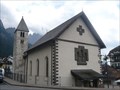
|   St. Christopher church - San Martino di Castrozza, Italy St. Christopher church - San Martino di Castrozza, Italy
in Roman Catholic Churches The small church of San Martino di Castrozza near the main road near the square. posted by:  Vymitac Vymitac location: Trentino–Alto Adige, Italy date approved: 11/20/2012 last visited: never |
 view gallery view gallery N16.1 km N16.1 km
|  Marmolada, Italy Marmolada, Italy
in Geographic High Points Marmolada is a mountain in northeastern Italy and the highest mountain of the Dolomites (a section of the Alps). posted by: btrodrigues location: Veneto, Italy date approved: 10/22/2011 last visited: 03/06/2008 |
 view gallery view gallery NE17.1 km NE17.1 km
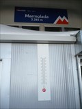
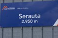
|  Serauta Station, Marmolada (2950m) Serauta Station, Marmolada (2950m)
in Elevation Signs Aerial trumway station between Malga Ciapela and Punta Rocca (Marmolada). posted by: KateBum location: Trentino–Alto Adige, Italy date approved: 07/16/2009 last visited: 03/06/2008 |
 view gallery view gallery NW17.4 km NW17.4 km
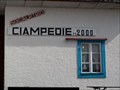
| Rifugio Ciampedie SAT (2000m) in Elevation Signs Mountain hut in the Rosengarten group. posted by: KateBum location: Trentino–Alto Adige, Italy date approved: 07/17/2009 last visited: never |
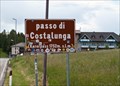 view gallery view galleryNW17.7 km | Passo di Costalunga (1752m) in Elevation Signs Elevation sign on top of the mountain pass. posted by: KateBum location: Trentino–Alto Adige, Italy date approved: 07/15/2009 last visited: 06/23/2013 |
 view gallery view galleryNW17.9 km | Rifugio Roda di Vael (2283m) in Elevation Signs Mountain hut in the Rosengarten group. posted by: KateBum location: Trentino–Alto Adige, Italy date approved: 07/15/2009 last visited: 08/01/2015 |
 view gallery view galleryNW18.2 km | Rifugio Paolina (2125m) in Elevation Signs Mountain hut in the Rosengarten group. posted by: KateBum location: Trentino–Alto Adige, Italy date approved: 07/15/2009 last visited: 07/24/2018 |
 view gallery view gallery W18.5 km W18.5 km
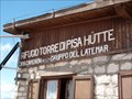
| Rifugio Torre di Pisa (2671m) in Elevation Signs Mountain hut in the Latemar group. posted by: KateBum location: Trentino–Alto Adige, Italy date approved: 07/17/2009 last visited: 07/16/2018 |
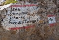 view gallery view galleryNW18.8 km | Forcella del Camosci, Latemar (2564m) Gamsstallscharte in Elevation Signs Mountain gorge in the Latemar Group. posted by: KateBum location: Trentino–Alto Adige, Italy date approved: 07/19/2009 last visited: 07/17/2018 |
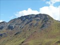 view gallery view galleryN19.8 km |  Col del Cuc 2558m Col del Cuc 2558m
in Mountain Summits Col del Cuc 2558m posted by: DasUmmi location: Veneto, Italy date approved: 10/11/2011 last visited: never |
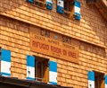
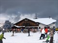
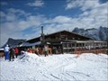 view gallery view galleryN20.1 km |  Il Rifugio Club Moritzino (Piz La Ila), Italy Il Rifugio Club Moritzino (Piz La Ila), Italy
in Ski Lodges Club Moritzino on Piz La Ila Mountain is, besides your casual break from skiing, a gathering point for society and a must for all who love entertainment. The club’s fish evenings, DJ music, and evening skiing sessions are also legendary. posted by: btrodrigues location: Trentino–Alto Adige, Italy date approved: 10/23/2011 last visited: never |
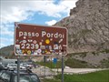 view gallery view galleryN21.1 km | Passo Pordoi (2239m) in Elevation Signs Elevation sign on top of the mountain pass. posted by: KateBum location: Trentino–Alto Adige, Italy date approved: 07/16/2009 last visited: 09/06/2010 |
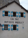 view gallery view galleryNW21.1 km | Rifugio Vajolet SAT (2243m) in Elevation Signs Mountain hut in the Rosengarten group.
posted by: KateBum location: Trentino–Alto Adige, Italy date approved: 07/17/2009 last visited: 07/16/2019 |
 view gallery view galleryNW22.2 km | Rifugio Passo Principe (2600m) in Elevation Signs Mountain hut in the Rosengarten group. posted by: KateBum location: Trentino–Alto Adige, Italy date approved: 07/17/2009 last visited: never |
 view gallery view galleryNW22.2 km | Passo Principe (2601m) in Elevation Signs Mountain gorge in the Rosengarten group.
posted by: KateBum location: Trentino–Alto Adige, Italy date approved: 07/17/2009 last visited: never |
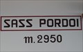 view gallery view galleryN22.4 km | Sass Pordoi (2950m) in Elevation Signs Within the aerial ropeway station on the Sass Pordoi. posted by: KateBum location: Trentino–Alto Adige, Italy date approved: 07/16/2009 last visited: 09/06/2010 |
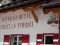 view gallery view galleryN22.5 km | Rifugio Forcella Pordoi (2848m) in Elevation Signs Mountain hut at the way to Piz Boe. posted by: KateBum location: Trentino–Alto Adige, Italy date approved: 07/15/2009 last visited: 07/28/2015 |
 view gallery view galleryNW23 km | Passo Nigra (1690m) in Elevation Signs Mountain pass at Rosengarten group. posted by: KateBum location: Trentino–Alto Adige, Italy date approved: 07/17/2009 last visited: never |
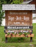 view gallery view galleryNW23 km | Niger Joch Haus (1690m) in Elevation Signs Mountain hut near Passo Nigra at Rosengarten group.
posted by: KateBum location: Trentino–Alto Adige, Italy date approved: 07/17/2009 last visited: never |
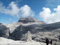 view gallery view galleryN23.2 km | Piz Boè (3152m) in Mountain Summits Piz Boè - höchster Berg der Sellagruppe.
Piz Boe - the highest mountain in the Sella group. posted by: DasUmmi location: Trentino–Alto Adige, Italy date approved: 10/23/2011 last visited: 07/28/2015 |
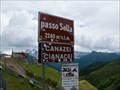 view gallery view galleryN23.2 km | Passo Sella (2240m) in Elevation Signs Elevation sign on top of the mountain pass. posted by: KateBum location: Trentino–Alto Adige, Italy date approved: 07/15/2009 last visited: 08/24/2020 |
 view gallery view galleryN23.5 km | Rifugio Capanna Fassa (3152m) in Elevation Signs Mountain hut on the summit of Piz Boe. posted by: KateBum location: Trentino–Alto Adige, Italy date approved: 07/15/2009 last visited: 09/06/2010 |
 view gallery view galleryN24 km | Rifugio Boe SAT (2873m) in Elevation Signs Mountain hut at the way to Piz Boe. posted by: KateBum location: Trentino–Alto Adige, Italy date approved: 07/15/2009 last visited: 09/06/2010 |
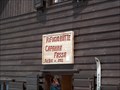
 view gallery view galleryN25.3 km | Rifugio Cherz - Arabba, Italy in Ski Lodges Hut in 2095 m. posted by: Arne1 location: Veneto, Italy date approved: 03/21/2011 last visited: never |
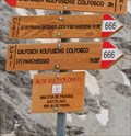 view gallery view galleryN26.4 km |  Alpine trail 666: Pisciadú chalet - Colfosco, Italy Alpine trail 666: Pisciadú chalet - Colfosco, Italy
in 666 Sightings One of many alpine trails in Italian Dolomites, in mountain group Sella, is numbered 666. Trail starts by mountain challet Pisciadú and hikers can descent to village of Colfosco (Calfosch/Kolfuschg) or to mountain saddle Passo Gardena. posted by: Rikitan location: Trentino–Alto Adige, Italy date approved: 09/14/2014 last visited: 09/10/2010 |
|