 view gallery view gallery SW8.7 km SW8.7 km
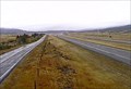
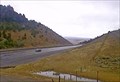
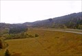
|   Elk Park North Camera - Butte, MT Elk Park North Camera - Butte, MT
in Web Cameras This is one of 73 (as of January 2017) Road Weather Information System camera sites operated by the Montana Department of Transportation to aid motorists as they make their way across BIG SKY Country. posted by:  T0SHEA T0SHEA location: Montana date approved: 01/27/2017 last visited: never |
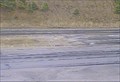
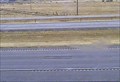 view gallery view gallerySW8.7 km | Elk Park Roadway Camera - Butte, MT in Web Cameras This is one of 73 (as of January 2017) Road Weather Information System camera sites operated by the Montana Department of Transportation to aid motorists as they make their way across BIG SKY Country. posted by: T0SHEA location: Montana date approved: 01/27/2017 last visited: never |
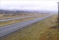 view gallery view gallerySW8.7 km | Elk Park South Camera - Butte, MT in Web Cameras This is one of 73 (as of January 2017) Road Weather Information System camera sites operated by the Montana Department of Transportation to aid motorists as they make their way across BIG SKY Country. posted by: T0SHEA location: Montana date approved: 01/27/2017 last visited: never |
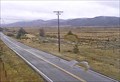 view gallery view gallerySW8.7 km | Elk Park Frontage Road Camera - Butte, MT in Web Cameras This is one of 73 (as of January 2017) Road Weather Information System camera sites operated by the Montana Department of Transportation to aid motorists as they make their way across BIG SKY Country. posted by: T0SHEA location: Montana date approved: 01/27/2017 last visited: never |
 view gallery view gallery NE9.5 km NE9.5 km
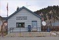
|  Basin, Montana 59631 Basin, Montana 59631
in U.S. Post Offices This Post Office is located at 100 Basin Street in Basin, Montana. posted by: brwhiz location: Montana date approved: 11/22/2011 last visited: 04/14/2014 |
 view gallery view gallery E17.2 km E17.2 km
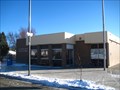
| Boulder, MT 59632 in U.S. Post Offices This Post Office serves the town of Boulder and its surrounding community of approximately 1,400 people.
posted by:  CerealBoxMonsters CerealBoxMonsters location: Montana date approved: 12/13/2009 last visited: 09/21/2016 |
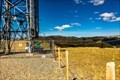 view gallery view galleryE19.2 km |  Boulder Mountain Repeater Boulder Mountain Repeater
in Amateur Radio Repeaters The Boulder Mountain Repeater is housed in a former AT&T transmitter building on top of Boulder Mountain in Jefferson County, Montana. posted by: mtbearded1 location: Montana date approved: 07/22/2020 last visited: never |
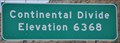 view gallery view gallerySW20.9 km |  Continental Divide ~ Elevation 6393 feet Continental Divide ~ Elevation 6393 feet
in Elevation Signs This Elevation Sign sits on the east side of Interstate Highway 15 at the summit where it crosses the Continental Divide. posted by: brwhiz location: Montana date approved: 10/17/2012 last visited: never |
 view gallery view gallerySW24.6 km | Butte, Montana 59701 ~ Walkerville Station in U.S. Post Offices This Post Office is located at 42 W Daly Street in Butte, Montana. posted by: brwhiz location: Montana date approved: 11/22/2011 last visited: never |
 view gallery view galleryNE24.6 km | Boulder Hill Southeast Webcam - Boulder, MT in Web Cameras This is one of 73 (as of January 2017) Road Weather Information System cameras operated by the Montana Department of Transportation to aid motorists as they make their way across BIG SKY Country. posted by: T0SHEA location: Montana date approved: 01/10/2017 last visited: never |
 view gallery view galleryNE24.6 km | Boulder Hill Roadway Webcam - Boulder, MT in Web Cameras This is one of 73 (as of January 2017) Road Weather Information System cameras operated by the Montana Department of Transportation to aid motorists as they make their way across BIG SKY Country. posted by: T0SHEA location: Montana date approved: 01/10/2017 last visited: never |
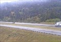 view gallery view galleryNE24.8 km | Boulder Hill Northeast Webcam - Boulder, MT in Web Cameras This is one of 73 (as of January 2017) Road Weather Information System cameras operated by the Montana Department of Transportation to aid motorists as they make their way across BIG SKY Country. posted by: T0SHEA location: Montana date approved: 01/10/2017 last visited: never |
 view gallery view galleryNE24.8 km | Boulder Hill North Webcam - Boulder, MT in Web Cameras This is one of 73 (as of January 2017) Road Weather Information System cameras operated by the Montana Department of Transportation to aid motorists as they make their way across BIG SKY Country. posted by: T0SHEA location: Montana date approved: 01/10/2017 last visited: never |
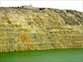 view gallery view gallerySW25.4 km |  Berkeley Pit pumping and treating to begin, possibly this year Berkeley Pit pumping and treating to begin, possibly this year
in News Article Locations One mile long by half a mile wide and 1,780 feet deep, Berkeley Pit is one of the largest Superfund sites in Montana. Coordinates are for the reception/gift show visitor center. posted by: T0SHEA location: Montana date approved: 02/28/2018 last visited: 07/18/2023 |
 view gallery view gallerySW25.4 km |  Berkeley Pit - Butte, MT Berkeley Pit - Butte, MT
in Official Local Tourism Attractions One mile long by half a mile wide and 1,780 feet deep, Berkeley Pit is one of the largest Superfund sites in Montana. Coordinates are for the reception/gift show visitor center. posted by: T0SHEA location: Montana date approved: 03/02/2018 last visited: 07/18/2023 |
 view gallery view gallerySW25.4 km |  Berkeley Pit - Butte, MT Berkeley Pit - Butte, MT
in Lucky 7 One mile long by half a mile wide and 1,780 feet deep, Berkeley Pit is one of the largest Superfund sites in Montana. Coordinates are for the reception/gift show visitor center. posted by: T0SHEA location: Montana date approved: 03/02/2018 last visited: 07/18/2023 |
 view gallery view gallerySW25.4 km |  Berkeley Pit - Butte, MT Berkeley Pit - Butte, MT
in Mines One mile long by half a mile wide and 1,780 feet deep, Berkeley Pit is one of the largest Superfund sites in Montana. Coordinates are for the reception/gift show visitor center. posted by: T0SHEA location: Montana date approved: 03/01/2018 last visited: 07/18/2023 |
 view gallery view gallerySW25.4 km |  Berkeley Pit - Butte, MT Berkeley Pit - Butte, MT
in Wikipedia Entries One mile long by half a mile wide and 1,780 feet deep, Berkeley Pit is one of the largest Superfund sites in Montana. Coordinates are for the reception/gift show visitor center. posted by: T0SHEA location: Montana date approved: 02/28/2018 last visited: 07/18/2023 |
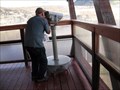 view gallery view gallerySW25.4 km |  Binoculars at Berkeley Pit, Butte, MT Binoculars at Berkeley Pit, Butte, MT
in Coin-Op Binoculars Use these free binoculars to view the massive Berkeley Open Mining Pit in Butte, MT. (Free after $2 admission fee to the viewing platform) posted by: Queens Blessing location: Montana date approved: 10/18/2010 last visited: 07/18/2023 |
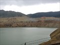
 view gallery view gallerySW25.4 km | Berkeley Pit, Butte Montana Elevation 5,610 feet in Elevation Signs This elevation sign is at the entrance to the Berkeley Pit viewing platform, in Butte, Montana. posted by: Queens Blessing location: Montana date approved: 10/16/2010 last visited: 07/18/2023 |
 view gallery view gallerySW25.4 km |  The Berkeley Pit, Butte, MT The Berkeley Pit, Butte, MT
in Roadside Attractions The Berkeley Pit, a 7,000 foot long open mining pit, is located in Butte, Montana. posted by: Queens Blessing location: Montana date approved: 10/17/2010 last visited: 07/18/2023 |
 view gallery view gallerySW25.4 km |  Berkeley Pit - Butte, Montana Berkeley Pit - Butte, Montana
in Super Fund Sites Berkeley Pit is one of the largest Superfund sites in Montana, the coordinates are for the reception/gift show visitor center. posted by: T0SHEA location: Montana date approved: 03/09/2018 last visited: 07/18/2023 |
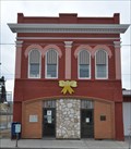
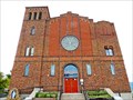 view gallery view gallerySW25.7 km |  Former St. Mary's Catholic Church - Butte, MT Former St. Mary's Catholic Church - Butte, MT
in Roman Catholic Churches From 1933 until 1978 St. Mary's Roman Catholic Church was the major church of the Irish community in Butte. posted by: T0SHEA location: Montana date approved: 08/27/2017 last visited: never |
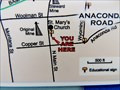 view gallery view gallerySW25.7 km |  You Are at St. Mary's Church - Butte, MT You Are at St. Mary's Church - Butte, MT
in 'You Are Here' Maps From 1933 until 1978 St. Mary's Roman Catholic Church was the major church of the Irish community in Butte. This map is mounted at the corner of East Gagnon and North Main Streets, off to the side of the church. posted by: T0SHEA location: Montana date approved: 08/27/2017 last visited: never |
 view gallery view gallerySW25.7 km |  St. Mary's Catholic Church - Butte, MT St. Mary's Catholic Church - Butte, MT
in Unique Steeples From 1933 until 1978 St. Mary's Roman Catholic Church was the major church of the Irish community in Butte. posted by: T0SHEA location: Montana date approved: 08/29/2017 last visited: never |
|