 view gallery view gallery N18.5 km N18.5 km
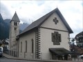
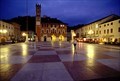
|   St. Christopher church - San Martino di Castrozza, Italy St. Christopher church - San Martino di Castrozza, Italy
in Roman Catholic Churches The small church of San Martino di Castrozza near the main road near the square. posted by:  Vymitac Vymitac location: Trentino–Alto Adige, Italy date approved: 11/20/2012 last visited: never |
 view gallery view gallery NW32.5 km NW32.5 km
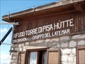
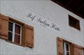
|  Rifugio Torre di Pisa (2671m) Rifugio Torre di Pisa (2671m)
in Elevation Signs Mountain hut in the Latemar group. posted by: KateBum location: Trentino–Alto Adige, Italy date approved: 07/17/2009 last visited: 07/16/2018 |
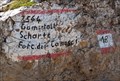 view gallery view galleryNW33.2 km | Forcella del Camosci, Latemar (2564m) Gamsstallscharte in Elevation Signs Mountain gorge in the Latemar Group. posted by: KateBum location: Trentino–Alto Adige, Italy date approved: 07/19/2009 last visited: 07/17/2018 |
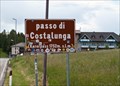 view gallery view galleryN35.6 km | Passo di Costalunga (1752m) in Elevation Signs Elevation sign on top of the mountain pass. posted by: KateBum location: Trentino–Alto Adige, Italy date approved: 07/15/2009 last visited: 06/23/2013 |
 view gallery view gallery W36 km W36 km
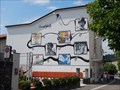
|  Cinematograff - Levico Terme, Italy Cinematograff - Levico Terme, Italy
in Murals Mural made by graffiti artists depicting the history of cinema in Levico Terme posted by:  Becktracker Becktracker location: Trentino–Alto Adige, Italy date approved: 01/26/2021 last visited: 08/07/2014 |
 view gallery view galleryN36.7 km | Rifugio Paolina (2125m) in Elevation Signs Mountain hut in the Rosengarten group. posted by: KateBum location: Trentino–Alto Adige, Italy date approved: 07/15/2009 last visited: 07/24/2018 |
 view gallery view galleryN36.7 km | Rifugio Roda di Vael (2283m) in Elevation Signs Mountain hut in the Rosengarten group. posted by: KateBum location: Trentino–Alto Adige, Italy date approved: 07/15/2009 last visited: 08/01/2015 |
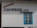 view gallery view galleryN37.7 km | Rifugio Ciampedie SAT (2000m) in Elevation Signs Mountain hut in the Rosengarten group. posted by: KateBum location: Trentino–Alto Adige, Italy date approved: 07/17/2009 last visited: never |
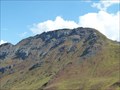
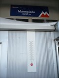 view gallery view galleryN38.1 km |  Marmolada, Italy Marmolada, Italy
in Geographic High Points Marmolada is a mountain in northeastern Italy and the highest mountain of the Dolomites (a section of the Alps). posted by: btrodrigues location: Veneto, Italy date approved: 10/22/2011 last visited: 03/06/2008 |
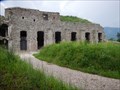 view gallery view galleryW38.3 km |  Forte di Tenna - Tenna, Italy Forte di Tenna - Tenna, Italy
in Historic Forts Remains of a fort which was important during World War I posted by: Becktracker location: Trentino–Alto Adige, Italy date approved: 01/17/2021 last visited: 08/03/2014 |
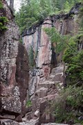 view gallery view galleryNW38.5 km |  Die Dolomiten - Bletterbach Schlucht Die Dolomiten - Bletterbach Schlucht
in World Heritage Sites Die geologisch interessante Bletterbach-Schlucht ist seit 2009 'World Heritage Site' der UNESCO. /
The Bletterbach canyon and its interesting geological features have become a UNESCO World Heritage Site in 2009. posted by: netdust location: Trentino–Alto Adige, Italy date approved: 07/11/2011 last visited: 07/19/2017 |
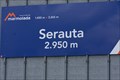 view gallery view galleryN38.9 km | Serauta Station, Marmolada (2950m) in Elevation Signs Aerial trumway station between Malga Ciapela and Punta Rocca (Marmolada). posted by: KateBum location: Trentino–Alto Adige, Italy date approved: 07/16/2009 last visited: 03/06/2008 |
 view gallery view gallery S40.1 km S40.1 km
|  Piazza degli Scacchi (Chess Square), Marostica, Italy Piazza degli Scacchi (Chess Square), Marostica, Italy
in Giant Board Games Legend has it that, in 1454, two knights played a game of chess for the hand of a maiden, with armed, living "pieces." A yearly festival is held in Marostica to commemorate it. posted by: hzoi location: Veneto, Italy date approved: 02/05/2022 last visited: 02/06/2022 |
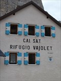 view gallery view galleryN40.9 km | Rifugio Vajolet SAT (2243m) in Elevation Signs Mountain hut in the Rosengarten group.
posted by: KateBum location: Trentino–Alto Adige, Italy date approved: 07/17/2009 last visited: 07/16/2019 |
 view gallery view galleryN41.5 km | Passo Nigra (1690m) in Elevation Signs Mountain pass at Rosengarten group. posted by: KateBum location: Trentino–Alto Adige, Italy date approved: 07/17/2009 last visited: never |
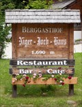 view gallery view galleryN41.5 km | Niger Joch Haus (1690m) in Elevation Signs Mountain hut near Passo Nigra at Rosengarten group.
posted by: KateBum location: Trentino–Alto Adige, Italy date approved: 07/17/2009 last visited: never |
 view gallery view galleryN42.2 km |  Col del Cuc 2558m Col del Cuc 2558m
in Mountain Summits Col del Cuc 2558m posted by: DasUmmi location: Veneto, Italy date approved: 10/11/2011 last visited: never |
 view gallery view galleryN42.3 km | Rifugio Passo Principe (2600m) in Elevation Signs Mountain hut in the Rosengarten group. posted by: KateBum location: Trentino–Alto Adige, Italy date approved: 07/17/2009 last visited: never |
 view gallery view galleryN42.3 km | Passo Principe (2601m) in Elevation Signs Mountain gorge in the Rosengarten group.
posted by: KateBum location: Trentino–Alto Adige, Italy date approved: 07/17/2009 last visited: never |
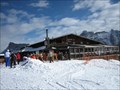 view gallery view galleryN42.5 km |  Il Rifugio Club Moritzino (Piz La Ila), Italy Il Rifugio Club Moritzino (Piz La Ila), Italy
in Ski Lodges Club Moritzino on Piz La Ila Mountain is, besides your casual break from skiing, a gathering point for society and a must for all who love entertainment. The club’s fish evenings, DJ music, and evening skiing sessions are also legendary. posted by: btrodrigues location: Trentino–Alto Adige, Italy date approved: 10/23/2011 last visited: never |
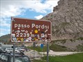 view gallery view galleryN43.5 km | Passo Pordoi (2239m) in Elevation Signs Elevation sign on top of the mountain pass. posted by: KateBum location: Trentino–Alto Adige, Italy date approved: 07/16/2009 last visited: 09/06/2010 |
 view gallery view galleryNW44.6 km | Chiese di San Pietro - Ora, Italy in Roman Catholic Churches Chiese di San Pietro in Ora. posted by: lumbricus location: Trentino–Alto Adige, Italy date approved: 08/22/2024 last visited: never |
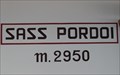 view gallery view galleryN44.7 km | Sass Pordoi (2950m) in Elevation Signs Within the aerial ropeway station on the Sass Pordoi. posted by: KateBum location: Trentino–Alto Adige, Italy date approved: 07/16/2009 last visited: 09/06/2010 |
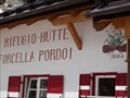 view gallery view galleryN44.9 km | Rifugio Forcella Pordoi (2848m) in Elevation Signs Mountain hut at the way to Piz Boe. posted by: KateBum location: Trentino–Alto Adige, Italy date approved: 07/15/2009 last visited: 07/28/2015 |
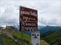 view gallery view galleryN45.4 km | Passo Sella (2240m) in Elevation Signs Elevation sign on top of the mountain pass. posted by: KateBum location: Trentino–Alto Adige, Italy date approved: 07/15/2009 last visited: 08/24/2020 |
|