 view gallery view gallery S2.7 km S2.7 km
|   Fairmount, North Dakota 58030 Fairmount, North Dakota 58030
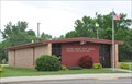
in U.S. Post Offices This Post Office is located at 202 Main Avenue in Fairmount, North Dakota. posted by:  brwhiz brwhiz location: North Dakota date approved: 06/29/2013 last visited: never |
 view gallery view gallery SE11.9 km SE11.9 km
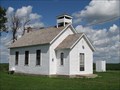
|  District No. 44 School - Taylor Township, Minnesota District No. 44 School - Taylor Township, Minnesota
in One-Room Schoolhouses One-room schoolhouse near Tintah, Minnesota. posted by: msrubble location: Minnesota date approved: 01/09/2015 last visited: never |
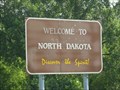 view gallery view galleryS16.1 km |  ND / SD on State Hwy 127 ND / SD on State Hwy 127
in Border Crossings This quiet Border Crossing is on State Highway 127 between North Dakota and South Dakota. posted by: PeterNoG location: South Dakota date approved: 12/27/2011 last visited: 09/15/2019 |
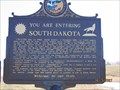 view gallery view galleryS16.1 km |  You are entering South Dakota (2) You are entering South Dakota (2)
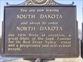
in South Dakota Historical Markers Welcome to South Dakota! Created with its twin North Dakota, 2 November 1889, its 77,047 square miles ranks 15th in size. posted by: MNSearchers location: South Dakota date approved: 04/16/2007 last visited: 09/15/2019 |
 view gallery view galleryS16.1 km | You are entering Roberts County South Dakota 4 in South Dakota Historical Markers Long the home of Sisseton, Wahpeton & Cuthead Yanktonaise Sioux, it became part of Deuel & Cheyenne Counties in 1862. posted by: MNSearchers location: South Dakota date approved: 04/16/2007 last visited: 09/15/2019 |
 view gallery view galleryS16.1 km | You are now leaving South Dakota in South Dakota Historical Markers You are now leaving South Dakota posted by: MNSearchers location: South Dakota date approved: 04/16/2007 last visited: 09/15/2019 |
 view gallery view galleryS16.1 km | You are about to enter Richland County ND in South Dakota Historical Markers The southerly most 4 miles of Richland County posted by: MNSearchers location: South Dakota date approved: 04/16/2007 last visited: 09/15/2019 |
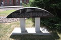
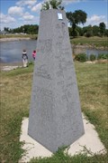
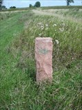 view gallery view galleryS16.3 km |  Minnesota - North Dakota - South Dakota Tri-point Witness Monument Minnesota - North Dakota - South Dakota Tri-point Witness Monument
in U.S. Historic Survey Stones and Monuments A stone post marking the location where the states of Minnesota, North Dakota, and South Dakota meet near White Rock, South Dakota. However, the monument appears to actually be located in the state of North Dakota. posted by: Marine Biologist location: North Dakota date approved: 09/02/2009 last visited: 08/25/2023 |
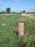 view gallery view galleryS16.3 km |  Tripoint - Minnesota, North Dakota, and South Dakota Tripoint - Minnesota, North Dakota, and South Dakota
in Tripoints and Multipoints A stone post marks the location where the states of Minnesota, North Dakota, and South Dakota meet near White Rock, South Dakota. posted by: Marine Biologist location: North Dakota date approved: 03/12/2012 last visited: 08/25/2023 |
 view gallery view galleryS17.7 km |  Augustana Lutheran Church - SD Augustana Lutheran Church - SD
in Country Churches A church located in the ghost town of.... posted by: MNSearchers location: South Dakota date approved: 04/19/2007 last visited: 04/19/2007 |
 view gallery view galleryS17.7 km |  White Rock South Dakota White Rock South Dakota
in Ghost Towns Ghost Town. In 2000 the census had the population of 18 and in recent years I understand there is only like 2 people here now. posted by: MNSearchers location: South Dakota date approved: 04/17/2007 last visited: 11/13/2011 |
 view gallery view galleryS17.7 km |  White Rock, South Dakota White Rock, South Dakota
in Wikipedia Entries The town of White Rock, South Dakota, once had a population of 600. Today's it's essentially a ghost town with a population of only 18 people documented during the 2000 census. posted by: Marine Biologist location: South Dakota date approved: 09/05/2009 last visited: 11/13/2011 |
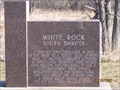
 view gallery view galleryS17.7 km | White Rock, South Dakota in South Dakota Historical Markers This historical marker features the now very small town of White Rock, located along the Bois de Sioux River in Roberts County, South Dakota. posted by: Marine Biologist location: South Dakota date approved: 08/31/2009 last visited: 11/13/2011 |
 view gallery view gallery N20.1 km N20.1 km
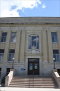
|  Wilkin County Courthouse - Breckenridge, MN Wilkin County Courthouse - Breckenridge, MN
in U.S. National Register of Historic Places The Wilkin County Courthouse is on the National Register of Historic Places. posted by: Benchmark Blasterz location: Minnesota date approved: 12/19/2013 last visited: 08/27/2015 |
 view gallery view galleryN20.1 km |  Wilkin Co. Courthouse -- Breckenridge MN Wilkin Co. Courthouse -- Breckenridge MN
in Civil Defense Fallout Shelters The Wilkin County Courthouse is also a fallout shelter. posted by: Benchmark Blasterz location: Minnesota date approved: 12/23/2013 last visited: 08/27/2015 |
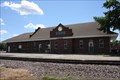 view gallery view galleryN20.4 km |  Great Northern RR Depot - -Breckenridge MN Great Northern RR Depot - -Breckenridge MN
in Train Stations/Depots The historic Great Northern RR depot in Breckenridge MN serves now as a division office for the local short-line Red River Valley & Western RR posted by: Benchmark Blasterz location: Minnesota date approved: 12/18/2013 last visited: 09/05/2021 |
 view gallery view galleryN20.4 km |  Last Rail Spiked at Breckenridge -- Breckenridge MN Last Rail Spiked at Breckenridge -- Breckenridge MN
in Minnesota Historical Markers This interesting historic marker preserves the history of the last spike in a railroad that opened a trade corridor between the continental US and Canada. posted by: Benchmark Blasterz location: Minnesota date approved: 12/25/2013 last visited: 08/01/2017 |
 view gallery view galleryN20.4 km |  Boomer -- Breckenridge MN Boomer -- Breckenridge MN
in Animal Memorials A touching memorial to Boomer, a stray dog who showed up at the Breckenridge MN Great Northern RR depot in 1927 and became the unofficial station pet for the next 10 years. posted by: Benchmark Blasterz location: Minnesota date approved: 12/18/2013 last visited: 08/01/2017 |
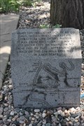 view gallery view galleryN20.4 km | Breckenridge-Wahpeton Street Railway Company -- Breckenridge MN in Minnesota Historical Markers A small granite block historic marker and some old rails are all that remain of the Breckenridge-Wahpeton Street railway company. posted by: Benchmark Blasterz location: Minnesota date approved: 12/17/2013 last visited: 08/01/2017 |
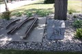 view gallery view galleryN20.4 km |  SHORTEST -- Interstate streetcar line, Breckenridge MN SHORTEST -- Interstate streetcar line, Breckenridge MN
in Superlatives A small granite block historic marker and some old rails are all that remain of the Breckenridge-Wahpeton Street railway company, the shortest interstate streetcar line in the United States. posted by: Benchmark Blasterz location: Minnesota date approved: 12/17/2013 last visited: 08/01/2017 |
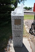
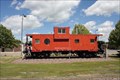 view gallery view galleryN20.4 km |  Great Northern Caboose X111 -- Breckenridge MN Great Northern Caboose X111 -- Breckenridge MN
in Train Cabooses This Great Northern RR caboose was obtained by the city, refurbished, and installed in a small roadside park in 1990. posted by: Benchmark Blasterz location: Minnesota date approved: 12/27/2013 last visited: 09/05/2021 |
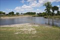 view gallery view galleryN20.6 km |  CONFLUENCE -- Otter Tail & Bois de Sioux Rivers, & ORIGIN of the Red River of the North -- Breckenridge MN CONFLUENCE -- Otter Tail & Bois de Sioux Rivers, & ORIGIN of the Red River of the North -- Breckenridge MN
in River Origins, Destinations and Confluences The confluence of the Otter Tail and Bois de Sioux rivers in Breckenridge MN forms the Red River of the North, the longest north-flowing river in the United States. posted by: Benchmark Blasterz location: Minnesota date approved: 12/17/2013 last visited: 05/09/2021 |
 view gallery view galleryN20.6 km | Headwaters of the Red River of the North -- Breckenridge MN in Minnesota Historical Markers A carved grey granite historic marker in Headwaters Park in downtown Breckenridge MN posted by: Benchmark Blasterz location: Minnesota date approved: 12/25/2013 last visited: 05/09/2021 |
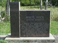
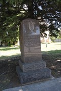 view gallery view galleryN20.8 km |  Memorial to Union Veterans of the Civil War -- Wahpeton ND Memorial to Union Veterans of the Civil War -- Wahpeton ND
in American Civil War Monuments and Memorials A memorial to the Union veterans of Richland County ND by the Women's Relief Corps Post 7 stands proudly on the southwest corner of the County Courthouse grounds in Wahpeton ND. posted by: Benchmark Blasterz location: North Dakota date approved: 12/20/2013 last visited: 08/27/2015 |
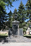 view gallery view galleryN20.8 km |  "Over the Top" WWI Memorial -- Wahpeton ND "Over the Top" WWI Memorial -- Wahpeton ND
in World War I Memorials and Monuments The Wahpeton/Richland Co. ND WWI memorial stands tall in the southeast corner of the Richland County Courthouse grounds. posted by: Benchmark Blasterz location: North Dakota date approved: 12/19/2013 last visited: 08/27/2015 |
|