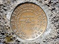
 view gallery view gallery SW14.5 km SW14.5 km
|   16WF1955 - Klickitat County, WA 16WF1955 - Klickitat County, WA
in U.S. Benchmarks In front of the Logs Inn Pub and lodge posted by:  Team 11E Team 11E location: Washington date approved: 03/08/2018 last visited: never |
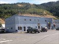 view gallery view gallery SE22.7 km SE22.7 km
|  Klickitat, WA. 98628 Klickitat, WA. 98628
in U.S. Post Offices The post office building in Klickitat, WA. posted by:  Volcanoguy Volcanoguy location: Washington date approved: 10/07/2009 last visited: 09/21/2009 |
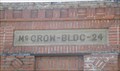 view gallery view gallerySE22.7 km |  1924 - McCrow Building - Klickitat, Washington 1924 - McCrow Building - Klickitat, Washington
in Dated Buildings and Cornerstones The 1924 McCrow Building in Klickitat, Washington. posted by: Volcanoguy location: Washington date approved: 01/29/2010 last visited: 09/21/2009 |
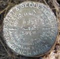 view gallery view gallerySE24.5 km | RC1047 - USCGS P274, Washington in U.S. Benchmarks U.S. Coast & Geodetic Survey benchmark P274 posted by: Volcanoguy location: Washington date approved: 01/30/2010 last visited: 09/21/2009 |
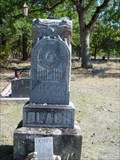 view gallery view gallery S25.3 km S25.3 km
|  R. Lee Black Woodman of the World R. Lee Black Woodman of the World
in Woodmen of the World Grave Markers/Monuments Lyle-Balch cemetery Lyle, Washington posted by: brokenoaks location: Washington date approved: 10/12/2008 last visited: never |
 view gallery view galleryS25.3 km |  White Salmon SDA Church White Salmon SDA Church
in Seventh-day Adventist Churches Neat old church in White Salmon, WA posted by: X$r location: Washington date approved: 07/09/2008 last visited: never |
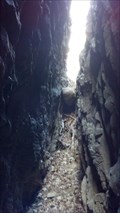 view gallery view galleryS25.4 km |  Catherine Creek Glacial Erratic, Washington Catherine Creek Glacial Erratic, Washington
in Glacial Lake Missoula Flood Features At Catherine Creek a difficult and treacherous climb through the window leads to the gap behind, where a granitic boulder (an erratic) is wedged in the crevasse on the north end of the gap. posted by: Rose Red location: Washington date approved: 04/11/2012 last visited: never |
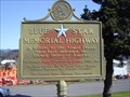 view gallery view galleryS27.7 km |  I-84 - Hood River, OR I-84 - Hood River, OR
in Blue Star Memorial Highway Markers Located right off the I-84 west bound at exit #64 by "Tourist Info". posted by: beagle39z location: Oregon date approved: 05/05/2011 last visited: never |
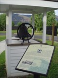 view gallery view galleryS27.7 km |  Oak Grove School Bell Oak Grove School Bell
in Bells A former school bell on display outside a museum in Hood River posted by: TheBeanTeam location: Oregon date approved: 12/21/2006 last visited: 03/08/2009 |
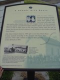 view gallery view galleryS27.7 km |  A School With Roots A School With Roots
in Oregon Historical Markers An Oregon historical marker just outside the historical museums entrance in Hood River. "This bell was made by American Bell Foundry and was donated to the Hood River County Historical Museum in 1980 my descendants of the Crapper Family." posted by: TheBeanTeam location: Oregon date approved: 01/16/2007 last visited: 03/08/2009 |
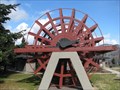 view gallery view galleryS27.7 km |  Henderson Paddle Wheel - Hood River, Oregon Henderson Paddle Wheel - Hood River, Oregon
in Ship Screws and Aircraft Props Paddle wheel from river steamer tow boat on display in Hood River, Oregon. posted by:  BruceS BruceS location: Oregon date approved: 04/25/2009 last visited: 11/27/2020 |
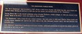 view gallery view galleryS27.7 km |  Henderson Paddle Wheel - Hood River, Oregon Henderson Paddle Wheel - Hood River, Oregon
in Signs of History Plaque giving a brief history a paddle wheel and river steamer it came from on display in Hood River, Oregon. posted by: BruceS location: Oregon date approved: 04/25/2009 last visited: 06/30/2006 |
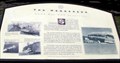 view gallery view galleryS27.7 km | The Henderson - Gone by Not Forgotten - Hood River, Oregon in Oregon Historical Markers Historical marker giving a brief history of a Columbia River steamer. posted by: BruceS location: Oregon date approved: 04/26/2009 last visited: 06/30/2006 |
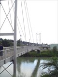 view gallery view galleryS27.7 km |  Columbia Gorge Sailpark Pedestrian Bridge Columbia Gorge Sailpark Pedestrian Bridge
in Pedestrian Suspension Bridges Pedestrian Bridge over Hood River near its mouth at the Columbia. posted by: TheBeanTeam location: Oregon date approved: 12/21/2006 last visited: 12/26/2013 |
 view gallery view galleryS27.8 km |  Victor Trevitt's Grave, Memaloose Island, Oregon Victor Trevitt's Grave, Memaloose Island, Oregon
in Out of Place Graves Victor Trevitt was buried in 1883 on Memaloose Island according to his wish to be buried here among the people he loved. posted by: Rose Red location: Oregon date approved: 09/02/2009 last visited: 09/25/2015 |
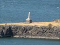
 view gallery view galleryS27.8 km |  Sepulchar Island, near Hood River, Oregon Sepulchar Island, near Hood River, Oregon
in Lewis and Clark Trail The Corps of Discovery passed this point twice on their journey, and posted and explored the island on 13 April 1806. Today, the island is referred to as "Memaloose Island" but the explorers called it "sepulchar island". posted by: Queens Blessing location: Oregon date approved: 09/17/2012 last visited: 08/31/2013 |
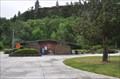 view gallery view galleryS27.8 km |  Memaloose Park Rest Area ~ Eastbound Memaloose Park Rest Area ~ Eastbound
in Highway Rest Areas The Memaloose Park Rest Area is located on the south side of Interstate Highway 84, within the boundaries of Memaloose State Park, about 3.1 miles east of Mosier, Oregon. posted by: brwhiz location: Oregon date approved: 02/04/2013 last visited: 06/25/2014 |
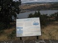
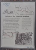
 view gallery view galleryS27.8 km |  The Oregon Trail ~ Pathway to the "Garden of the World" The Oregon Trail ~ Pathway to the "Garden of the World"
in Wagon Roads and Trails This is one of 13 historical markers in a special kiosk, devoted to the history of the Oregon Trail, and located at the Memaloose Park Rest Area on the south side of Interstate Highway 84 about 3.1 miles east of Mosier, Oregon. posted by: brwhiz location: Oregon date approved: 02/04/2013 last visited: 06/25/2014 |
 view gallery view galleryS27.8 km | Pathway to the "Garden of the World" in Oregon Historical Markers This is one of 13 historical markers in a special kiosk, devoted to the history of the Oregon Trail, and located at the Memaloose Park Rest Area on the south side of Interstate Highway 84 about 3.1 miles east of Mosier, Oregon. posted by: brwhiz location: Oregon date approved: 02/03/2013 last visited: 06/25/2014 |
 view gallery view galleryS27.8 km |  The Oregon Trail - Pathway to the "Garden of the World" ~ Mosier, Oregon, USA The Oregon Trail - Pathway to the "Garden of the World" ~ Mosier, Oregon, USA
in Human Migration Monuments A special kiosk, housing 13 historical markers devoted to the history of the Oregon Trail, is located at the Memaloose Park Rest Area on the south side of Interstate Highway 84 about 3.1 miles east of Mosier, Oregon. posted by: brwhiz location: Oregon date approved: 02/04/2013 last visited: 06/25/2014 |
 view gallery view galleryS27.8 km | Diseases Devastate Tribes in Oregon Historical Markers This is one of 13 historical markers in a special kiosk, devoted to the history of the Oregon Trail, and located at the Memaloose Park Rest Area on the south side of Interstate Highway 84 about 3.1 miles east of Mosier, Oregon. posted by: brwhiz location: Oregon date approved: 02/05/2013 last visited: 06/25/2014 |
 view gallery view galleryS27.8 km | Indians and Emigrants in Oregon Historical Markers This is one of 13 historical markers in a special kiosk, devoted to the history of the Oregon Trail, and located at the Memaloose Park Rest Area on the south side of Interstate Highway 84 about 3.1 miles east of Mosier, Oregon. posted by: brwhiz location: Oregon date approved: 02/05/2013 last visited: 06/25/2014 |
 view gallery view galleryS27.8 km | Land Not for Sale in Oregon Historical Markers This is one of 13 historical markers in a special kiosk, devoted to the history of the Oregon Trail, and located at the Memaloose Park Rest Area on the south side of Interstate Highway 84 about 3.1 miles east of Mosier, Oregon. posted by: brwhiz location: Oregon date approved: 02/05/2013 last visited: 06/25/2014 |
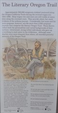 view gallery view galleryS27.8 km | The Literary Oregon Trail in Oregon Historical Markers This is one of 13 historical markers in a special kiosk, devoted to the history of the Oregon Trail, and located at the Memaloose Park Rest Area on the south side of Interstate Highway 84 about 3.1 miles east of Mosier, Oregon. posted by: brwhiz location: Oregon date approved: 02/05/2013 last visited: 06/25/2014 |
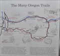 view gallery view galleryS27.8 km | The Many Oregon Trails in Oregon Historical Markers This is one of 13 historical markers in a special kiosk, devoted to the history of the Oregon Trail, and located at the Memaloose Park Rest Area on the south side of Interstate Highway 84 about 3.1 miles east of Mosier, Oregon. posted by: brwhiz location: Oregon date approved: 02/05/2013 last visited: 06/25/2014 |
|