 view gallery view gallery N20.9 km N20.9 km
|   McDonald's MABLY on N7 McDonald's MABLY on N7
in McDonald's Restaurants on the N7, at the entrance of agglomeration of Roannes posted by:  JMRetSB JMRetSB location: Auvergne-Rhône-Alpes, France date approved: 08/24/2012 last visited: 08/19/2012 |
 view gallery view gallery W23.3 km W23.3 km
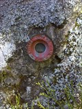
|  D 51 - Saint-Priest-Laprugne - France D 51 - Saint-Priest-Laprugne - France
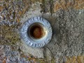
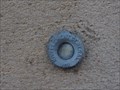
in French Benchmarks REPÈRE CYLINDRIQUE DU NIVELLEMENT GÉNÉRAL posted by: JMRetSB location: Auvergne-Rhône-Alpes, France date approved: 05/10/2017 last visited: 04/14/2015 |
 view gallery view gallery NW23.7 km NW23.7 km
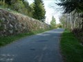
|  La route Magique - Les Noes - France La route Magique - Les Noes - France
in Vortexes, Mystery Spots, and Gravity Hills Les monts de la Madeleine possèdent une route qui défie la raison. C'est la route magique.
Mountains of "la Madeleine" have a road that defies reason. This is the magic road. posted by: Alfouine location: Auvergne-Rhône-Alpes, France date approved: 12/23/2018 last visited: never |
 view gallery view galleryNW23.7 km |  La route Magique - Les Noes - France La route Magique - Les Noes - France
in Official Local Tourism Attractions Les monts de la Madeleine possèdent une route qui défie la raison. C'est la route magique.
Mountains of "la Madeleine" have a road that defies reason. This is the magic road. posted by: Alfouine location: Auvergne-Rhône-Alpes, France date approved: 12/24/2018 last visited: never |
 view gallery view galleryNW23.7 km |  La route Magique - Les Noes - France La route Magique - Les Noes - France
in Weird Story Locations Les monts de la Madeleine possèdent une route qui défie la raison. C'est la route magique.
Mountains of "la Madeleine" have a road that defies reason. This is the magic road. posted by: Alfouine location: Auvergne-Rhône-Alpes, France date approved: 07/18/2017 last visited: never |
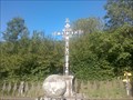 view gallery view galleryNW24.6 km |  Le calvaire de Terrenoire - France Le calvaire de Terrenoire - France
in Christian Crosses Dans le hameau de Terrenoire un grand calvaire entourée par une grille.
In the hamlet of Terrenoire a great calvary surrounded by a gate. posted by: Alfouine location: Auvergne-Rhône-Alpes, France date approved: 01/22/2017 last visited: never |
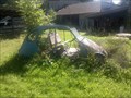 view gallery view galleryNW26.6 km |  L'épave de 2CV - La Chabanne - France L'épave de 2CV - La Chabanne - France
in Abandoned Dead Vehicles Une vielle épave de 2CV envahi par les herbes.
An old wreck of 2CV overgrown with herbs. posted by: Alfouine location: Auvergne-Rhône-Alpes, France date approved: 01/27/2017 last visited: never |
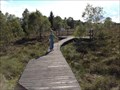 view gallery view galleryNW26.6 km |  La Tourbière du plateau de la Verrerie (Rhône Alpes, France) La Tourbière du plateau de la Verrerie (Rhône Alpes, France)
in Non-Coastal Boardwalks discovery "La Tourbière du plateau de la Verrerie"
description of the earth hides GC31BPK posted by:  Dragon Ball Dragon Ball location: Auvergne-Rhône-Alpes, France date approved: 02/14/2016 last visited: 05/02/2015 |
 view gallery view galleryNW28 km | Mairie de Saint-Nicolas-des-Biefs in French Benchmarks Repère cylindrique de nivellement à droite de la facade. posted by: JMRetSB location: Auvergne-Rhône-Alpes, France date approved: 07/19/2014 last visited: 07/13/2014 |
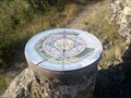
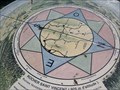 view gallery view galleryNW29.1 km |  Le rocher Saint Vincent - Lavoine - France Le rocher Saint Vincent - Lavoine - France
in Compass Roses Rose des vents à l'intérieur d'une table d'orientation en haut du rocher Saint Vincent.
Compass rose inside a table of orientation at the top of the rock Saint Vincent. posted by: Alfouine location: Auvergne-Rhône-Alpes, France date approved: 02/10/2017 last visited: never |
 view gallery view galleryNW29.1 km |  Le rocher Saint Vincent - Lavoine - France Le rocher Saint Vincent - Lavoine - France
in Orientation Tables Table d’orientation, pour admirer le bassin Vichyssois, la chaîne des Puys, mais également la région de Bourges et les Alpes du Sud.
Table orientation, to admire the Vichyssois, the chain of Puys, but also the region of Bourges and the Southern alps. posted by: Alfouine location: Auvergne-Rhône-Alpes, France date approved: 01/27/2017 last visited: never |
 view gallery view galleryN29.9 km | Benchmark - Church of Pouilly sous Charlieu in French Benchmarks Benchmark at the church of Pouilly sous Charlieu - Höhenfestpunkt an der Kirche von Pouilly sous Charlieu posted by: Windego1 location: Auvergne-Rhône-Alpes, France date approved: 06/22/2014 last visited: 07/09/2017 |
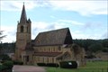
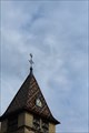 view gallery view galleryN30.3 km | Benchmark - Point Géodésique - Église Saint-Irénée - Briennon, France in French Benchmarks Repère géodésique du point 1, au sommet du clocher, sur l'axe et au centre de la croix, avec un Azimut de la prise de vue égal à 150 gr. posted by: pmaupin location: Auvergne-Rhône-Alpes, France date approved: 08/05/2017 last visited: 07/10/2017 |
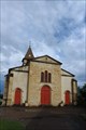
 view gallery view galleryN30.3 km |  Église Saint Irénée - Briennon, France Église Saint Irénée - Briennon, France
in Roman Catholic Churches [EN] The church contains a modern vessel and an ancient choir, dating from the end of the 11th or the beginning of the 12th century.
[FR] L'église comporte un vaisseau moderne et un chœur ancien, daté de la fin du XIe ou du début du XIIe siècle. posted by: pmaupin location: Auvergne-Rhône-Alpes, France date approved: 01/23/2018 last visited: 07/10/2017 |
 view gallery view galleryN30.3 km |  Église Saint Irénée - Briennon, France Église Saint Irénée - Briennon, France
in Monuments Historiques Français [FR] L'église comporte un vaisseau moderne et un chœur ancien, daté de la fin du XIe ou du début du XIIe siècle.
[EN] The church contains a modern vessel and an ancient choir, dating from the end of the 11th or the beginning of the 12th century. posted by: pmaupin location: Auvergne-Rhône-Alpes, France date approved: 08/05/2017 last visited: 07/10/2017 |
 view gallery view galleryN30.3 km |  Église Saint Irénée - Briennon, France Église Saint Irénée - Briennon, France
in Medieval Churches [EN] The church contains a modern vessel and an ancient choir, dating from the end of the 11th or the beginning of the 12th century. [FR] L'église comporte un vaisseau moderne et un chœur ancien, daté de la fin du XIe ou du début du XIIe siècle. posted by: pmaupin location: Centre-Val-de-Loire, France date approved: 01/23/2018 last visited: 07/10/2017 |
 view gallery view galleryN30.3 km | Église Saint Irénée - Briennon, France in This Old Church [EN] The church contains a modern vessel and an ancient choir, dating from the end of the 11th or the beginning of the 12th century. [FR] L'église comporte un vaisseau moderne et un chœur ancien, daté de la fin du XIe ou du début du XIIe siècle. posted by: pmaupin location: Auvergne-Rhône-Alpes, France date approved: 01/23/2018 last visited: 07/10/2017 |
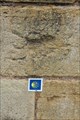
 view gallery view galleryN30.3 km | Benchmark - Église Saint Irénée - Briennon, France in French Benchmarks Le Repère Cylindrique du Nivellement Général se situe sur le soubassement de l'about du contrefort de l'église côté "St Germain, face à la route. posted by: pmaupin location: Auvergne-Rhône-Alpes, France date approved: 08/05/2017 last visited: 07/10/2017 |
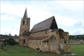
 view gallery view galleryN30.4 km | Abbaye de la Bénisson-Dieu - La Bénisson-Dieu, France in Monuments Historiques Français [FR] L’ancienne abbaye de Notre-Dame-de-la-Bénédiction-de-Dieu était une implantation cistercienne en terre bénédictine.
[EN] The former abbey of Notre-Dame-de-la-Bénédiction-de-Dieu was a Cistercian settlement in Benedictine land. posted by: pmaupin location: Auvergne-Rhône-Alpes, France date approved: 07/13/2017 last visited: 07/11/2017 |
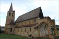 view gallery view galleryN30.4 km | Eglise Notre-Dame-et-Saint-Bernard - La Bénisson-Dieu, France in Roman Catholic Churches [EN] Church of the former abbey of Our Lady of the Blessing of God, Cistercian settlement in Benedictine land. [FR] Eglise de l’ancienne abbaye de Notre-Dame-de-la-Bénédiction-de-Dieu, implantation cistercienne en terre bénédictine. posted by: pmaupin location: Auvergne-Rhône-Alpes, France date approved: 01/23/2018 last visited: 07/10/2017 |
 view gallery view galleryN30.4 km | Eglise Notre-Dame-et-Saint-Bernard - La Bénisson-Dieu, France in This Old Church [EN] Church of the former abbey of Our Lady of the Blessing of God, Cistercian settlement in Benedictine land.
[FR] Eglise de l’ancienne abbaye de Notre-Dame-de-la-Bénédiction-de-Dieu, implantation cistercienne en terre bénédictine. posted by: pmaupin location: Auvergne-Rhône-Alpes, France date approved: 01/23/2018 last visited: 07/10/2017 |
 view gallery view galleryN30.4 km | Eglise Notre-Dame-et-Saint-Bernard - La Bénisson-Dieu, France in Medieval Churches [EN] Church of the former abbey of Our Lady of the Blessing of God, Cistercian settlement in Benedictine land. [FR] Eglise de l’ancienne abbaye de Notre-Dame-de-la-Bénédiction-de-Dieu, implantation cistercienne en terre bénédictine. posted by: pmaupin location: Auvergne-Rhône-Alpes, France date approved: 01/23/2018 last visited: 07/10/2017 |
 view gallery view galleryN30.4 km |  Abbaye de la Bénisson-Dieu - La Bénisson-Dieu, France Abbaye de la Bénisson-Dieu - La Bénisson-Dieu, France
in Wikipedia Entries [EN] The former abbey of Notre-Dame-de-la-Bénédiction-de-Dieu was a Cistercian settlement in Benedictine land.
[FR] L’ancienne abbaye de Notre-Dame-de-la-Bénédiction-de-Dieu était une implantation cistercienne en terre bénédictine. posted by: pmaupin location: Auvergne-Rhône-Alpes, France date approved: 07/10/2017 last visited: 07/10/2017 |
 view gallery view galleryN30.4 km |  Abbaye de la Bénisson-Dieu - La Bénisson-Dieu, France Abbaye de la Bénisson-Dieu - La Bénisson-Dieu, France
in Abbeys, Convents and Monasteries [EN] The former abbey of Notre-Dame-de-la-Bénédiction-de-Dieu was a Cistercian settlement in Benedictine land.
[FR] L’ancienne abbaye de Notre-Dame-de-la-Bénédiction-de-Dieu était une implantation cistercienne en terre bénédictine. posted by: pmaupin location: Auvergne-Rhône-Alpes, France date approved: 07/18/2017 last visited: 07/10/2017 |
 view gallery view galleryN30.4 km |  Le Chemin de Cluny - De Charlieu à Montbrison - La Bénisson-Dieu, France Le Chemin de Cluny - De Charlieu à Montbrison - La Bénisson-Dieu, France
in Way of St. James [EN] The former abbey of Notre-Dame-de-la-Blessing-of-God on the way to Cluny, part of the road to Saint-Jacques.
[FR] L’ancienne abbaye de Notre-Dame-de-la-Bénédiction-de-Dieu sur le chemin de Cluny, partie du chemin de Saint-Jacques. posted by: pmaupin location: Auvergne-Rhône-Alpes, France date approved: 01/24/2018 last visited: 01/23/2018 |
|