 view gallery view gallery N29.3 km N29.3 km
|   McDonald's MABLY on N7 McDonald's MABLY on N7
in McDonald's Restaurants on the N7, at the entrance of agglomeration of Roannes posted by:  JMRetSB JMRetSB location: Auvergne-Rhône-Alpes, France date approved: 08/24/2012 last visited: 08/19/2012 |
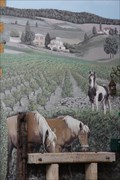 view gallery view gallery E34.4 km E34.4 km
|  Les chevaux - Chessy les mines - Rhône Les chevaux - Chessy les mines - Rhône
in Murals mural in the land of golden stone
fresque murale au pays des pierres dorées posted by: JMRetSB location: Auvergne-Rhône-Alpes, France date approved: 10/15/2013 last visited: 10/05/2013 |
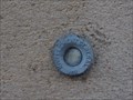 view gallery view galleryN36.5 km |  Benchmark - Church of Pouilly sous Charlieu Benchmark - Church of Pouilly sous Charlieu
in French Benchmarks Benchmark at the church of Pouilly sous Charlieu - Höhenfestpunkt an der Kirche von Pouilly sous Charlieu posted by: Windego1 location: Auvergne-Rhône-Alpes, France date approved: 06/22/2014 last visited: 07/09/2017 |
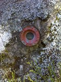 view gallery view gallery W36.5 km W36.5 km
| D 51 - Saint-Priest-Laprugne - France in French Benchmarks REPÈRE CYLINDRIQUE DU NIVELLEMENT GÉNÉRAL posted by: JMRetSB location: Auvergne-Rhône-Alpes, France date approved: 05/10/2017 last visited: 04/14/2015 |
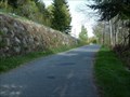 view gallery view gallery NW36.7 km NW36.7 km
|  La route Magique - Les Noes - France La route Magique - Les Noes - France
in Vortexes, Mystery Spots, and Gravity Hills Les monts de la Madeleine possèdent une route qui défie la raison. C'est la route magique.
Mountains of "la Madeleine" have a road that defies reason. This is the magic road. posted by: Alfouine location: Auvergne-Rhône-Alpes, France date approved: 12/23/2018 last visited: never |
 view gallery view galleryNW36.7 km |  La route Magique - Les Noes - France La route Magique - Les Noes - France
in Official Local Tourism Attractions Les monts de la Madeleine possèdent une route qui défie la raison. C'est la route magique.
Mountains of "la Madeleine" have a road that defies reason. This is the magic road. posted by: Alfouine location: Auvergne-Rhône-Alpes, France date approved: 12/24/2018 last visited: never |
 view gallery view galleryNW36.7 km |  La route Magique - Les Noes - France La route Magique - Les Noes - France
in Weird Story Locations Les monts de la Madeleine possèdent une route qui défie la raison. C'est la route magique.
Mountains of "la Madeleine" have a road that defies reason. This is the magic road. posted by: Alfouine location: Auvergne-Rhône-Alpes, France date approved: 07/18/2017 last visited: never |
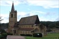
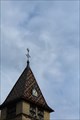 view gallery view galleryN37.3 km | Benchmark - Point Géodésique - Église Saint-Irénée - Briennon, France in French Benchmarks Repère géodésique du point 1, au sommet du clocher, sur l'axe et au centre de la croix, avec un Azimut de la prise de vue égal à 150 gr. posted by: pmaupin location: Auvergne-Rhône-Alpes, France date approved: 08/05/2017 last visited: 07/10/2017 |
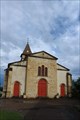
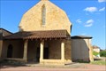
 view gallery view galleryN37.3 km |  Église Saint Irénée - Briennon, France Église Saint Irénée - Briennon, France
in Roman Catholic Churches [EN] The church contains a modern vessel and an ancient choir, dating from the end of the 11th or the beginning of the 12th century.
[FR] L'église comporte un vaisseau moderne et un chœur ancien, daté de la fin du XIe ou du début du XIIe siècle. posted by: pmaupin location: Auvergne-Rhône-Alpes, France date approved: 01/23/2018 last visited: 07/10/2017 |
 view gallery view galleryN37.3 km |  Église Saint Irénée - Briennon, France Église Saint Irénée - Briennon, France
in Monuments Historiques Français [FR] L'église comporte un vaisseau moderne et un chœur ancien, daté de la fin du XIe ou du début du XIIe siècle.
[EN] The church contains a modern vessel and an ancient choir, dating from the end of the 11th or the beginning of the 12th century. posted by: pmaupin location: Auvergne-Rhône-Alpes, France date approved: 08/05/2017 last visited: 07/10/2017 |
 view gallery view galleryN37.3 km |  Église Saint Irénée - Briennon, France Église Saint Irénée - Briennon, France
in Medieval Churches [EN] The church contains a modern vessel and an ancient choir, dating from the end of the 11th or the beginning of the 12th century. [FR] L'église comporte un vaisseau moderne et un chœur ancien, daté de la fin du XIe ou du début du XIIe siècle. posted by: pmaupin location: Centre-Val-de-Loire, France date approved: 01/23/2018 last visited: 07/10/2017 |
 view gallery view galleryN37.3 km | Église Saint Irénée - Briennon, France in This Old Church [EN] The church contains a modern vessel and an ancient choir, dating from the end of the 11th or the beginning of the 12th century. [FR] L'église comporte un vaisseau moderne et un chœur ancien, daté de la fin du XIe ou du début du XIIe siècle. posted by: pmaupin location: Auvergne-Rhône-Alpes, France date approved: 01/23/2018 last visited: 07/10/2017 |
 view gallery view galleryN37.3 km | Benchmark - Église Saint Irénée - Briennon, France in French Benchmarks Le Repère Cylindrique du Nivellement Général se situe sur le soubassement de l'about du contrefort de l'église côté "St Germain, face à la route. posted by: pmaupin location: Auvergne-Rhône-Alpes, France date approved: 08/05/2017 last visited: 07/10/2017 |
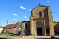
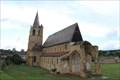
 view gallery view galleryN37.7 km | Abbaye Saint-Fortuné - Charlieu, France in Monuments Historiques Français [FR] L'Abbaye de Charlieu est située à 20 km de Roanne, à la limite de la Bourgogne, son nom vient de "Cher Lieu".
[EN] The Abbey of Charlieu is located 20 km from Roanne, on the border of Burgundy, its name comes from "Cher Lieu". posted by: pmaupin location: Auvergne-Rhône-Alpes, France date approved: 08/05/2017 last visited: 07/10/2017 |
 view gallery view galleryN37.7 km |  Abbaye Saint-Fortuné - Charlieu, France Abbaye Saint-Fortuné - Charlieu, France
in Wikipedia Entries [EN] The Abbey of Charlieu is located 20 km from Roanne, on the border of Burgundy, its name comes from "Cher Lieu".
[FR] L'Abbaye de Charlieu est située à 20 km de Roanne, à la limite de la Bourgogne, son nom vient de "Cher Lieu". posted by: pmaupin location: Auvergne-Rhône-Alpes, France date approved: 07/07/2017 last visited: 07/05/2017 |
 view gallery view galleryN37.7 km |  Abbaye de Charlieu - Charlieu, France Abbaye de Charlieu - Charlieu, France
in Abbeys, Convents and Monasteries [EN] The Abbey of Charlieu is located 20 km from Roanne, on the border of Burgundy, its name comes from "Cher Lieu". [FR] L'Abbaye de Charlieu est située à 20 km de Roanne, à la limite de la Bourgogne, son nom vient de "Cher Lieu". posted by: pmaupin location: Auvergne-Rhône-Alpes, France date approved: 08/05/2017 last visited: 07/10/2017 |
 view gallery view galleryN37.8 km | Couvent des Cordeliers - Saint-Nizier-sous-Charlieu, France in Monuments Historiques Français [FR] Fondé vers 1280 par une communauté de frères franciscains, le couvent connaît une histoire mouvementée.
[EN] Founded around 1280 by a community of Franciscan friars, the convent has a turbulent history. posted by: pmaupin location: Auvergne-Rhône-Alpes, France date approved: 07/11/2017 last visited: 07/05/2017 |
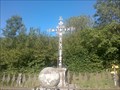 view gallery view galleryNW38.1 km |  Le calvaire de Terrenoire - France Le calvaire de Terrenoire - France
in Christian Crosses Dans le hameau de Terrenoire un grand calvaire entourée par une grille.
In the hamlet of Terrenoire a great calvary surrounded by a gate. posted by: Alfouine location: Auvergne-Rhône-Alpes, France date approved: 01/22/2017 last visited: never |
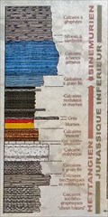 view gallery view galleryE38.3 km |  Pierres folles - 201Ma to 190Ma - Saint-Jean-des-Vignes - France Pierres folles - 201Ma to 190Ma - Saint-Jean-des-Vignes - France
in Timelines 10 Ma reveal themselves. The fault of crazy stones is the result of a field movement due to the formation of the Alps /\ 10 Ma se révèlent. La faille de pierres-folles est le resultat d'un mouvement de terrain du à la formation des Alpes. posted by: JMRetSB location: Bourgogne-Franche-Comté, France date approved: 05/23/2017 last visited: 02/13/2020 |
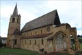 view gallery view galleryN38.5 km | Eglise Notre-Dame-et-Saint-Bernard - La Bénisson-Dieu, France in Roman Catholic Churches [EN] Church of the former abbey of Our Lady of the Blessing of God, Cistercian settlement in Benedictine land. [FR] Eglise de l’ancienne abbaye de Notre-Dame-de-la-Bénédiction-de-Dieu, implantation cistercienne en terre bénédictine. posted by: pmaupin location: Auvergne-Rhône-Alpes, France date approved: 01/23/2018 last visited: 07/10/2017 |
 view gallery view galleryN38.5 km | Abbaye de la Bénisson-Dieu - La Bénisson-Dieu, France in Monuments Historiques Français [FR] L’ancienne abbaye de Notre-Dame-de-la-Bénédiction-de-Dieu était une implantation cistercienne en terre bénédictine.
[EN] The former abbey of Notre-Dame-de-la-Bénédiction-de-Dieu was a Cistercian settlement in Benedictine land. posted by: pmaupin location: Auvergne-Rhône-Alpes, France date approved: 07/13/2017 last visited: 07/11/2017 |
 view gallery view galleryN38.5 km | Abbaye de la Bénisson-Dieu - La Bénisson-Dieu, France in Abbeys, Convents and Monasteries [EN] The former abbey of Notre-Dame-de-la-Bénédiction-de-Dieu was a Cistercian settlement in Benedictine land.
[FR] L’ancienne abbaye de Notre-Dame-de-la-Bénédiction-de-Dieu était une implantation cistercienne en terre bénédictine. posted by: pmaupin location: Auvergne-Rhône-Alpes, France date approved: 07/18/2017 last visited: 07/10/2017 |
 view gallery view galleryN38.5 km | Abbaye de la Bénisson-Dieu - La Bénisson-Dieu, France in Wikipedia Entries [EN] The former abbey of Notre-Dame-de-la-Bénédiction-de-Dieu was a Cistercian settlement in Benedictine land.
[FR] L’ancienne abbaye de Notre-Dame-de-la-Bénédiction-de-Dieu était une implantation cistercienne en terre bénédictine. posted by: pmaupin location: Auvergne-Rhône-Alpes, France date approved: 07/10/2017 last visited: 07/10/2017 |
 view gallery view galleryN38.5 km | Eglise Notre-Dame-et-Saint-Bernard - La Bénisson-Dieu, France in Medieval Churches [EN] Church of the former abbey of Our Lady of the Blessing of God, Cistercian settlement in Benedictine land. [FR] Eglise de l’ancienne abbaye de Notre-Dame-de-la-Bénédiction-de-Dieu, implantation cistercienne en terre bénédictine. posted by: pmaupin location: Auvergne-Rhône-Alpes, France date approved: 01/23/2018 last visited: 07/10/2017 |
 view gallery view galleryN38.5 km | Eglise Notre-Dame-et-Saint-Bernard - La Bénisson-Dieu, France in This Old Church [EN] Church of the former abbey of Our Lady of the Blessing of God, Cistercian settlement in Benedictine land.
[FR] Eglise de l’ancienne abbaye de Notre-Dame-de-la-Bénédiction-de-Dieu, implantation cistercienne en terre bénédictine. posted by: pmaupin location: Auvergne-Rhône-Alpes, France date approved: 01/23/2018 last visited: 07/10/2017 |
|