 view gallery view gallery N23.2 km N23.2 km
|   Little Sauk, MN Little Sauk, MN
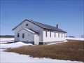
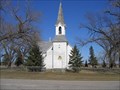
in City and Town Halls Small town hall in Todd County, MN. posted by:  lenron lenron location: Minnesota date approved: 03/26/2011 last visited: never |
 view gallery view gallery NW24.5 km NW24.5 km
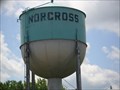
|  Water Tower - Norcross MN Water Tower - Norcross MN
in Water Towers This short water tower is on Griswold Avenue near Railroad Street in Norcross, Minnesota, posted by:  PeterNoG PeterNoG location: Minnesota date approved: 07/24/2016 last visited: 04/08/2017 |
 view gallery view gallery SW25.7 km SW25.7 km
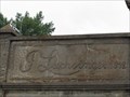
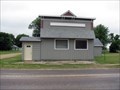
|  1912 - J. Luchsinger Store - Johnson, MN 1912 - J. Luchsinger Store - Johnson, MN
in Dated Buildings and Cornerstones In 2010, the J. Luchsinger Store on Main Street in Johnson, MN was an abandoned relic of the past. Johnson MN is the 42nd of 100 of the cities described in the book LITTLE MINNESOTA. posted by: Benchmark Blasterz location: Minnesota date approved: 07/11/2017 last visited: 07/15/2017 |
 view gallery view gallery NE29.8 km NE29.8 km
|  Glacial Ridge Trail Scenic Byway - Kensington Runestone Park - Kensington, MN Glacial Ridge Trail Scenic Byway - Kensington Runestone Park - Kensington, MN
in National Scenic Byways The Glacial Ridge Trail Scenic Byway passes through the Kensington Runestone Park in Kensington, Minnesota. posted by: Marine Biologist location: Minnesota date approved: 09/05/2009 last visited: 08/28/2009 |
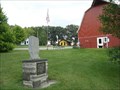
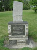 view gallery view galleryNE29.8 km |  Kensington Runestone Memorial - Kensington Runestone Park - Kensington, MN Kensington Runestone Memorial - Kensington Runestone Park - Kensington, MN
in Lions Clubs International Markers The Kensington Runestone Memorial, a replica of the real runestone that is now housed in the Runestone Museum in Alexandria, Minnesota, is located in the Kensington Runestone Park. It was erected by the Kensington Lions Club. posted by: Marine Biologist location: Minnesota date approved: 11/21/2010 last visited: never |
 view gallery view galleryNE29.8 km |  Kensington Runestone Park - Kensington, MN Kensington Runestone Park - Kensington, MN
in Municipal Parks and Plazas This park is named after the Kensington Runestone, which was found here in 1898. posted by: Marine Biologist location: Minnesota date approved: 09/05/2009 last visited: 08/28/2009 |
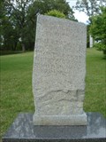 view gallery view galleryNE29.8 km |  Kensington Runestone Replica - Kensington, MN Kensington Runestone Replica - Kensington, MN
in Exact Replicas A replica of the infamous Kensington Runestone, which is now housed in the Runestone Museum in Alexandria, Minnesota, is located in the Kensington Runestone Park. posted by: Marine Biologist location: Minnesota date approved: 09/12/2009 last visited: 08/17/2012 |
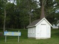 view gallery view galleryNE29.8 km |  Cliff Roiland Memorial Chapel - Kensington, Minnesota Cliff Roiland Memorial Chapel - Kensington, Minnesota
in Waychapels This small chapel is located in the Kensington Runestone Park in Kensington, Minnesota, USA. posted by: Marine Biologist location: Minnesota date approved: 09/03/2009 last visited: 08/28/2009 |
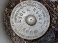
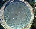 view gallery view galleryNE40.7 km |  State of Minn. Dept. Of Highways Bench Mark 2180, 39A, 1965 State of Minn. Dept. Of Highways Bench Mark 2180, 39A, 1965
in U.S. Benchmarks This benchmark is located at the intersection of I-94 and County Road 41 NW. posted by: jeromehasbargen location: Minnesota date approved: 11/07/2011 last visited: never |
 view gallery view galleryNE41 km | 2101 L RESET in U.S. Benchmarks Reset for a benchmark near Mill Lake in Douglas County, Minnesota. posted by: msrubble location: Minnesota date approved: 01/02/2013 last visited: never |
 view gallery view gallerySW42.3 km |  Eidskog Lutheran Church - MN Eidskog Lutheran Church - MN
in Country Churches Location Address:
5 Mi N 7 Mi E
Ortonville, MN 56278 posted by: MNSearchers location: Minnesota date approved: 06/08/2006 last visited: 07/02/2007 |
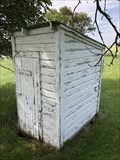 view gallery view galleryNW42.3 km |  Former School House Outhouse - Wheaton, MN Former School House Outhouse - Wheaton, MN
in Outhouses This outhouse is behind the Monson Town Hall in Traverse County. posted by: m&m O location: Minnesota date approved: 11/27/2021 last visited: never |
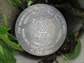 view gallery view galleryNW42.5 km | 7806 F in U.S. Benchmarks Minnesota Department of Transportation geodetic control mark in Monson Township. posted by: msrubble location: Minnesota date approved: 01/07/2015 last visited: never |
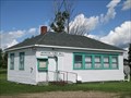 view gallery view galleryNW42.5 km | Monson Township, Minnesota in City and Town Halls Town hall for Monson Township, Traverse County, Minnesota. posted by: msrubble location: Minnesota date approved: 01/05/2015 last visited: never |
 view gallery view gallerySW43.9 km | St. Pauli Lutheran Church - MN in Country Churches Located on hiway 75 south of Clinton MN. posted by: MNSearchers location: Minnesota date approved: 04/17/2007 last visited: 04/17/2007 |
 view gallery view gallery W44.9 km W44.9 km
|  LITTLE MINNESOTA - 3 - Barry LITTLE MINNESOTA - 3 - Barry
in There's a Book About It This is the 3rd of the 100 cities described in the book LITTLE MINNESOTA. posted by: jiggs11 location: Minnesota date approved: 04/28/2014 last visited: never |
 view gallery view galleryN46.8 km |  Coot - Ashby, Minnesota Coot - Ashby, Minnesota
in Smithsonian Art Inventory Sculptures Large roadside sculpture of an American coot taking flight. posted by: msrubble location: Minnesota date approved: 01/15/2015 last visited: 05/16/2021 |
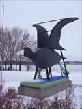 view gallery view galleryN46.8 km |  LARGEST -- Coot in the World LARGEST -- Coot in the World
in Superlatives The largest coot in the world is about to take flight into Ashby, Minnesota. posted by: msrubble location: Minnesota date approved: 02/14/2013 last visited: 05/16/2021 |
 view gallery view galleryN46.8 km |  Coot - Ashby, Minn. Coot - Ashby, Minn.
in Roadside Attractions Large roadside sculpture of an American coot taking flight. posted by: msrubble location: Minnesota date approved: 02/14/2013 last visited: 05/16/2021 |
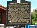 view gallery view galleryNE47.8 km |  Minnesota Watersheds Minnesota Watersheds
in Minnesota Historical Markers A watershed or drainage basin is the area of
land that drains water to a river, stream, or
lake. posted by: MNSearchers location: Minnesota date approved: 06/28/2008 last visited: 07/08/2015 |
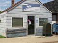 view gallery view gallery SE49.9 km SE49.9 km
|  Danvers, Minnesota 56231 Danvers, Minnesota 56231
in U.S. Post Offices Very small town post office. Elevation 1025 posted by: NGComets location: Minnesota date approved: 08/11/2016 last visited: never |
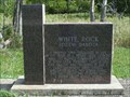 view gallery view galleryNW50.2 km |  White Rock, South Dakota White Rock, South Dakota
in South Dakota Historical Markers This historical marker features the now very small town of White Rock, located along the Bois de Sioux River in Roberts County, South Dakota. posted by: Marine Biologist location: South Dakota date approved: 08/31/2009 last visited: 11/13/2011 |
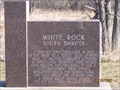
 view gallery view galleryNW50.2 km |  White Rock, South Dakota White Rock, South Dakota
in Wikipedia Entries The town of White Rock, South Dakota, once had a population of 600. Today's it's essentially a ghost town with a population of only 18 people documented during the 2000 census. posted by: Marine Biologist location: South Dakota date approved: 09/05/2009 last visited: 11/13/2011 |
 view gallery view galleryNW50.5 km |  White Rock South Dakota White Rock South Dakota
in Ghost Towns Ghost Town. In 2000 the census had the population of 18 and in recent years I understand there is only like 2 people here now. posted by: MNSearchers location: South Dakota date approved: 04/17/2007 last visited: 11/13/2011 |
 view gallery view galleryNW50.5 km | Augustana Lutheran Church - SD in Country Churches A church located in the ghost town of.... posted by: MNSearchers location: South Dakota date approved: 04/19/2007 last visited: 04/19/2007 |
|