 view gallery view gallery E14.8 km E14.8 km
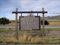
|   The Jefferson River (Lewis & Clark Expedition), Twin Bridges, MT The Jefferson River (Lewis & Clark Expedition), Twin Bridges, MT
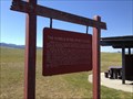
in Montana Historical Markers There are two Montana History signs in this pull-off from Hwy 41 near the town of Twin Bridges, both regarding the Lewis and Clark Expedition. posted by:  Queens Blessing Queens Blessing location: Montana date approved: 10/23/2010 last visited: 09/15/2012 |
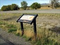 view gallery view galleryE14.8 km | Lewis & Clark Camped Here (Twin Bridges), Montana in Montana Historical Markers There are two Montana History signs in this pull-off from Hwy 41, near the town of Twin Bridges. posted by: Queens Blessing location: Montana date approved: 10/23/2010 last visited: 09/15/2012 |
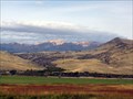 view gallery view galleryE14.8 km |  Beaverhead Trail, Twin Bridges, Montana Beaverhead Trail, Twin Bridges, Montana
in Ancient Traces and Roads The Jefferson Valley of Montana is the historical pathway for the seasonal migration of native Americans, later used by explorers (Lewis & Clark used it), settlers, and is now Highway 41. posted by: Queens Blessing location: Montana date approved: 10/24/2010 last visited: 09/15/2012 |
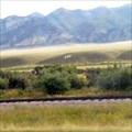 view gallery view galleryE15.4 km |  TB for Twin Bridges, Montana TB for Twin Bridges, Montana
in Letters on Hills The white letters "TB" are visible on the rolling hills near Twin Bridges, from highway 41. posted by: Queens Blessing location: Montana date approved: 10/24/2010 last visited: 09/02/2013 |
 view gallery view gallery NW24.6 km NW24.6 km
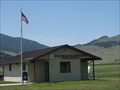
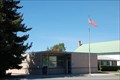
|  Divide, Montana 59727 Divide, Montana 59727
in U.S. Post Offices Located next to the Divide school posted by: ZenPanda location: Montana date approved: 11/08/2014 last visited: 10/03/2014 |
 view gallery view gallery W25.9 km W25.9 km
|  Elk Island Golf Course - Elk Island, Alberta Elk Island Golf Course - Elk Island, Alberta
in Public and Private Golf Courses Elk Island Golf Course is located in Elk Island National Park, 30 minutes east of Edmonton Alberta. posted by: machard location: Alberta, Canada date approved: 07/25/2022 last visited: never |
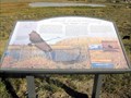 view gallery view gallery S26.7 km S26.7 km
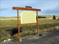
|  Beaverhead Sustained Productivity, Dillon, MT Beaverhead Sustained Productivity, Dillon, MT
in Flora and Fauna Information Signs The State of Montana has placed 4 signs at this overlook/highway pull-off. This one provides information and education on the grassland and ecology. posted by: Queens Blessing location: Montana date approved: 10/23/2010 last visited: 11/01/2010 |
 view gallery view galleryS26.7 km | Point of Rocks Stage Station, Dillon, MT in Montana Historical Markers There are 4 signs placed by the State of Montana at this overlook. posted by: Queens Blessing location: Montana date approved: 10/23/2010 last visited: 07/16/2013 |
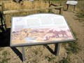 view gallery view galleryS26.7 km | Beaverhead Gateway Ranch, Dillon MT in Montana Historical Markers There are four signs placed by the State of Montana at this overlook. posted by: Queens Blessing location: Montana date approved: 10/23/2010 last visited: 09/15/2012 |
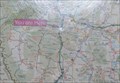 view gallery view galleryNW28.3 km |  Interstate 15 Divide Rest Area Interstate 15 Divide Rest Area
in 'You Are Here' Maps You Are Here at the Divide Rest Area on the east side of Interstate 15 between Exit 102 and Exit 111. posted by: brwhiz location: Montana date approved: 10/15/2012 last visited: never |
 view gallery view galleryNW28.3 km |  Interstate 15 Northbound Divide Rest Area Interstate 15 Northbound Divide Rest Area
in Highway Rest Areas The Montana Department of Transportation Divide Rest Area is located on the east side of Interstate 15 between Exit 102 and Exit 111. posted by: brwhiz location: Montana date approved: 10/17/2012 last visited: 07/18/2013 |
 view gallery view galleryNW28.3 km | The Humbug Spires Primitive Area, South Butte, Montana in Montana Historical Markers This Montana Historical Marker is located at the Divide Rest Area on the east side of Interstate 15 between Exit 102 and Exit 111. posted by:  Team gEco Friendly Team gEco Friendly location: Montana date approved: 08/11/2013 last visited: never |
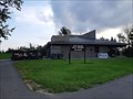
 view gallery view gallery SE29.8 km SE29.8 km
| Sheridan, Montana 59749 in U.S. Post Offices Sheridan, Montana's Post Office posted by: misfitt location: Montana date approved: 10/07/2007 last visited: 08/22/2013 |
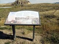
 view gallery view gallery NE34.3 km NE34.3 km
| A New World: Tertiary Mammals, Whitehall, MT in Montana Historical Markers This sign provided the long-ago history of Montana. posted by: Queens Blessing location: Montana date approved: 10/23/2010 last visited: 09/15/2012 |
 view gallery view gallery N34.8 km N34.8 km
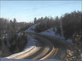
|  Homestake Pass East Camera - Butte, MT Homestake Pass East Camera - Butte, MT
in Web Cameras This is one of 73 (as of January 2017) Road Weather Information System camera sites operated by the Montana Department of Transportation to aid motorists as they make their way across BIG SKY Country. posted by: T0SHEA location: Montana date approved: 01/27/2017 last visited: never |
 view gallery view galleryN34.9 km | Homestake Pass Overpass Camera - Butte, MT in Web Cameras This is one of 73 (as of January 2017) Road Weather Information System camera sites operated by the Montana Department of Transportation to aid motorists as they make their way across BIG SKY Country. posted by: T0SHEA location: Montana date approved: 01/27/2017 last visited: never |
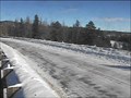
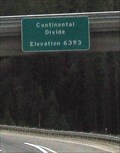 view gallery view galleryN34.9 km |  Continental Divide Elevation 6,393 feet, Homestake Pass, Montana Continental Divide Elevation 6,393 feet, Homestake Pass, Montana
in Elevation Signs Interstate I-90 crosses the Continental Divide at the elevation of 6,393 feet at the Homestake Pass, near Butte, MT. posted by: Queens Blessing location: Montana date approved: 10/17/2010 last visited: 05/13/2021 |
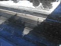 view gallery view galleryN34.9 km | Homestake Pass Roadway Camera - Butte, MT in Web Cameras This is one of 73 (as of January 2017) Road Weather Information System camera sites operated by the Montana Department of Transportation to aid motorists as they make their way across BIG SKY Country. posted by: T0SHEA location: Montana date approved: 01/27/2017 last visited: never |
 view gallery view galleryN34.9 km | Homestake Pass West Camera - Butte, MT in Web Cameras This is one of 73 (as of January 2017) Road Weather Information System camera sites operated by the Montana Department of Transportation to aid motorists as they make their way across BIG SKY Country. posted by: T0SHEA location: Montana date approved: 01/27/2017 last visited: never |
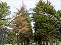
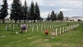
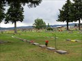 view gallery view galleryN37.7 km |  Holy Cross Cemetery - Veterans Section - Butte, Montana Holy Cross Cemetery - Veterans Section - Butte, Montana
in Veteran Cemeteries Holy Cross Cemetery - Veterans Section is near the center of the cemetery. Holy Cross Cemetery is adjacent to the Bert Mooney Airport to the south on Harrison Avenue/hwy. 2. posted by: T0SHEA location: Montana date approved: 02/03/2018 last visited: never |
 view gallery view galleryN37.7 km |  Holy Cross Cemetery - Butte, Montana Holy Cross Cemetery - Butte, Montana
in Worldwide Cemeteries Holy Cross Cemetery is adjacent to the Bert Mooney Airport to the south on Harrison Avenue/hwy. 2. posted by: T0SHEA location: Montana date approved: 02/03/2018 last visited: never |
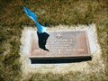 view gallery view galleryN37.7 km | Leo J. Powers-Butte, MT in Medal Of Honor Resting Places World War II Medal of Honor Recipient for action northwest of Cassino, Italy on February 3, 1944. He is buried in Holy Cross Cemetery, Butte, MT in Block 17, Lot 30. posted by: Don.Morfe location: Montana date approved: 12/06/2017 last visited: 12/19/2021 |
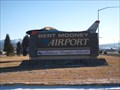 view gallery view galleryN38 km |  Bert Mooney Airport - Butte, MT Bert Mooney Airport - Butte, MT
in Airports This airport is located in Butte, Montana and is serviced by Delta Airlines. They have, on average, two scheduled flights a day. posted by: CerealBoxMonsters location: Montana date approved: 12/04/2009 last visited: 04/28/2012 |
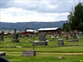
 view gallery view galleryN38.9 km | Mountain View Cemetery - Butte, Montana in Worldwide Cemeteries The Mountain View Cemetery is located on Harrison Avenue/Hwy. 2, about 1 mile north of Bert Mooney Airport. posted by: T0SHEA location: Montana date approved: 05/06/2019 last visited: 05/17/2022 |
 view gallery view galleryN38.9 km | Mountain View Cemetery - Veterans Section - Butte, Montana in Veteran Cemeteries The Mountain View Cemetery is located on Harrison Avenue/Hwy. 2, about 1 mile north of Bert Mooney Airport. The Veterans section is to the left after entering the cemetery. posted by: T0SHEA location: Montana date approved: 05/08/2019 last visited: 05/17/2022 |
|