 view gallery view gallery W14.8 km W14.8 km
|   #243 - Gibbonsville #243 - Gibbonsville
in Idaho Historical Markers History sign on U.S. Hwy. 93 south of Lost Pass. posted by:  Volcanoguy Volcanoguy location: Idaho date approved: 11/14/2012 last visited: 10/08/2010 |
 view gallery view galleryW18.7 km | Deep Creek in Idaho Historical Markers History sign on U.S. Hwy. 93 south of Lost Pass. posted by: Volcanoguy location: Idaho date approved: 11/14/2012 last visited: 10/08/2010 |
 view gallery view galleryW18.7 km |  Lewis and Clark at Deep Creek Lewis and Clark at Deep Creek
in Lewis and Clark Trail History sign on U.S. Hwy. 93 south of Lost Pass. posted by: Volcanoguy location: Idaho date approved: 10/13/2012 last visited: 10/08/2010 |
 view gallery view galleryW19.6 km | #448 - Nez Perce Trail in Idaho Historical Markers History sign on U.S. Hwy. 93 south of Lost Pass. posted by: Volcanoguy location: Idaho date approved: 11/14/2012 last visited: 10/08/2010 |
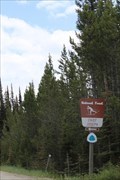 view gallery view gallery NW22.4 km NW22.4 km
|  Chief Joseph Cross Country Ski Trailhead -- Bitterroot National Forest, ID/MT USA Chief Joseph Cross Country Ski Trailhead -- Bitterroot National Forest, ID/MT USA
in Cross Country Ski Trailheads The Chief Joseph Cross Country Ski Trailhead at the Contnetal Divide near the borders of Idaho and Montana posted by: Benchmark Blasterz location: Montana date approved: 01/26/2023 last visited: 01/30/2023 |
 view gallery view galleryNW22.4 km |  Continental Divide at Chief Joseph Pass, Idaho/Montana Continental Divide at Chief Joseph Pass, Idaho/Montana
in Elevation Signs Elevation sign at Chief Joseph Pass on the Continental Divide. posted by: Volcanoguy location: Montana date approved: 01/10/2011 last visited: 01/25/2023 |
 view gallery view galleryNW22.4 km |  State Boundary Marker 42707M, Idaho/Montana State Boundary Marker 42707M, Idaho/Montana
in U.S. Benchmarks State Boundary Marker between Idaho and Montana at Chief Joseph Pass. posted by: Volcanoguy location: Montana date approved: 01/12/2011 last visited: 10/08/2010 |
 view gallery view galleryNW22.9 km | Jerry Fahey’s Cutoff in Idaho Historical Markers History sign on U.S. Hwy. 93 south of Lost Pass. posted by: Volcanoguy location: Idaho date approved: 11/14/2012 last visited: 10/08/2010 |
 view gallery view galleryNW22.9 km | Lost Trail Pass in Idaho Historical Markers History sign on U.S. Hwy. 93 south of Lost Pass. posted by: Volcanoguy location: Idaho date approved: 11/14/2012 last visited: 10/08/2010 |
 view gallery view galleryNW22.9 km | Foot Steps . . . in Idaho Historical Markers History sign on U.S. Hwy. 93 south of Lost Pass. posted by: Volcanoguy location: Idaho date approved: 11/14/2012 last visited: 10/08/2010 |
 view gallery view galleryNW22.9 km | Lewis and Clark - Lost Trail Pass in Lewis and Clark Trail History signs on U.S. Hwy. 93 south of Lost Trail Pass. posted by: Volcanoguy location: Idaho date approved: 10/15/2012 last visited: 10/08/2010 |
 view gallery view galleryNW23 km | Lewis and Clark - #269 in Lewis and Clark Trail History sign on U.S. Hwy. 93 south of Lost Pass. posted by: Volcanoguy location: Idaho date approved: 10/13/2012 last visited: 10/08/2010 |
 view gallery view galleryNW23 km | #269 - Lewis and Clark in Idaho Historical Markers History sign on U.S. Hwy. 93 south of Lost Pass. posted by: Volcanoguy location: Idaho date approved: 11/14/2012 last visited: 10/08/2010 |
 view gallery view galleryNW24 km |  Idaho/Montana on US Highway 93 Idaho/Montana on US Highway 93
in Border Crossings You cross the Idaho/Montana state border as you travel between Salmon, Idaho and Hamilton, Montana on US Highway 93. posted by: brwhiz location: Idaho date approved: 12/25/2012 last visited: 07/05/2012 |
 view gallery view galleryNW24 km |  Lost Trail Pass North Webcam - Lost Trail Pass, MT Lost Trail Pass North Webcam - Lost Trail Pass, MT
in Web Cameras This is one of about 150 highway traffic cameras in Idaho which cover every major and a great many of the minor thoroughfares in the state, as well as many of the towns and cities. posted by: T0SHEA location: Montana date approved: 04/05/2017 last visited: never |
 view gallery view galleryNW24 km | Lost Trail Pass - Which Way Did Lewis & Clark Go? in Lewis and Clark Trail History sign at Lost Trail Pass Rest Area. posted by: Volcanoguy location: Montana date approved: 10/15/2012 last visited: 10/08/2010 |
 view gallery view galleryNW24 km |  Which Way Did Lewis & Clark Go? Which Way Did Lewis & Clark Go?
in Montana Historical Markers History sign at Lost Trail Pass Rest Area. posted by: Volcanoguy location: Montana date approved: 10/15/2012 last visited: 10/08/2010 |
 view gallery view galleryNW24 km | Rugged Mountain Crossing in Montana Historical Markers History sign at Lost Trail Pass Rest Area. posted by: Volcanoguy location: Montana date approved: 10/15/2012 last visited: 10/08/2010 |
 view gallery view galleryNW24 km | Lost Trail Pass, Idaho/Montana in Elevation Signs Elevation sign at Lost Trail Pass between Idaho and Montana. posted by: Volcanoguy location: Montana date approved: 01/10/2011 last visited: 10/08/2010 |
 view gallery view galleryNW24 km |  Salmon River Scenic Byway - Lost Trail Pass, Montana/Idaho Salmon River Scenic Byway - Lost Trail Pass, Montana/Idaho
in National Scenic Byways Information sign for Salmon River Scenic Byway at Lost Trail Pass. posted by: Volcanoguy location: Montana date approved: 10/16/2012 last visited: 10/08/2010 |
 view gallery view galleryNW24 km |  Lost Trail Pass Rest Area - Montana Lost Trail Pass Rest Area - Montana
in Highway Rest Areas Lost Trail Pass Rest Area on U.S. Hwy. 93. posted by: Volcanoguy location: Montana date approved: 10/16/2012 last visited: 07/05/2012 |
 view gallery view gallery E24.1 km E24.1 km
|  Church of the Big Hole - Wisdom, Montana Church of the Big Hole - Wisdom, Montana
in Country Churches This beautiful church is located in a remote area and village in beautiful Montana. posted by:  misfitt misfitt location: Montana date approved: 11/29/2008 last visited: 09/08/2008 |
 view gallery view galleryE24.3 km |  Wisdom, MT 59761 Wisdom, MT 59761
in U.S. Post Offices Rural PO in small town posted by: ZenPanda location: Montana date approved: 10/18/2014 last visited: 10/19/2014 |
 view gallery view galleryE24.3 km |  Wisdom Lodge No. 61, Wisdom, Montana Wisdom Lodge No. 61, Wisdom, Montana
in Masonic Temples Located at 119 Elm St. posted by: ZenPanda location: Montana date approved: 11/11/2014 last visited: 04/12/2014 |
 view gallery view gallery SW24.5 km SW24.5 km
| #122 - Lewis and Clark in Idaho Historical Markers History sign on U.S. Hwy. 93 north of Salmon, Idaho. posted by: Volcanoguy location: Idaho date approved: 11/14/2012 last visited: 10/08/2010 |
|