 view gallery view gallery SE6.3 km SE6.3 km
|   Route 7 Highway Webcam - Welsford, NB Route 7 Highway Webcam - Welsford, NB
in Web Cameras The province of New Brunswick operates a network of highway webcams throughout the province to aid motorists in avoiding blizzards, downpours and any other nasty phenomena Mother Nature may have up her sleeve. posted by:  T0SHEA T0SHEA location: New Brunswick, Canada date approved: 05/15/2015 last visited: never |
 view gallery view gallery N10.6 km N10.6 km
| Route 7 Highway Webcam - Camp Petersville, NB in Web Cameras The province of New Brunswick operates a network of highway webcams throughout the province to aid motorists in avoiding blizzards, downpours and any other nasty phenomena Mother Nature may have up her sleeve. posted by: T0SHEA location: New Brunswick, Canada date approved: 05/01/2015 last visited: 07/02/2017 |
 view gallery view gallery W15.9 km W15.9 km
|  South Oromocto #3 Bell Bridge South Oromocto #3 Bell Bridge
in Covered Bridges SOUTH OROMOCTO RIVER #3 (Bell)
posted by:  stagunner stagunner location: New Brunswick, Canada date approved: 01/01/2008 last visited: 03/23/2001 |
 view gallery view gallery NW16.1 km NW16.1 km
| South Oromocto River No. 2 in Covered Bridges South Oromocto River No. 2 posted by: stagunner location: New Brunswick, Canada date approved: 11/18/2007 last visited: 07/02/2017 |
 view gallery view gallery E23.2 km E23.2 km
|  Canadian Hydrographic Service Benchmark Canadian Hydrographic Service Benchmark
in Canadian Benchmarks Canadian Hydrographic Survey Benchmark, located on the Beulah Campground Wharf at Browns Flat, New Brunswick. Used by CHS in gauging water levels on the Saint John River. posted by: Truenorth1867 location: New Brunswick, Canada date approved: 11/10/2011 last visited: never |
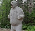 view gallery view galleryNW24.1 km |  The Peddler - Fredericton Junction, New Brunswick The Peddler - Fredericton Junction, New Brunswick
in Infamous Crime Scenes une statue du "Peddler" située à environ 2 km au sud-ouest sur Diamond Square Road à Fredericton Junction, Nouveau-Brunswicka / statue of the Peddler located about 2 km southwest on Diamond Square Road in Fredericton Junction, New Brunswick posted by: oiseau_ca location: New Brunswick, Canada date approved: 07/10/2023 last visited: never |
 view gallery view galleryNW24.1 km |  The Peddler - Fredericton Junction, New Brunswick The Peddler - Fredericton Junction, New Brunswick
in Roadside Attractions une statue du "Peddler" située à environ 2 km au sud-ouest sur Diamond Square Road à Fredericton Junction, Nouveau-Brunswicka / statue of the Peddler located about 2 km southwest on Diamond Square Road in Fredericton Junction, New Brunswick posted by: oiseau_ca location: New Brunswick, Canada date approved: 07/10/2023 last visited: never |
 view gallery view gallerySE29.3 km | Route 7 Highway Webcam - Grand Bay-Westfield, NB in Web Cameras The province of New Brunswick operates a network of highway webcams throughout the province to aid motorists in avoiding blizzards, downpours and any other nasty phenomena Mother Nature may have up her sleeve. posted by: T0SHEA location: New Brunswick, Canada date approved: 05/15/2015 last visited: never |
 view gallery view gallerySE34.9 km | Route 1 Highway Webcam - Saint John, NB in Web Cameras The province of New Brunswick operates a network of highway webcams throughout the province to aid motorists in avoiding blizzards, downpours and any other nasty phenomena Mother Nature may have up her sleeve. posted by: T0SHEA location: New Brunswick, Canada date approved: 04/30/2015 last visited: never |
 view gallery view gallerySE35.4 km |  CNHS - Major Gilfred Studholme - Saint-John, New Brunswick CNHS - Major Gilfred Studholme - Saint-John, New Brunswick
in Canadian National Historic Sites This plaque, in tribute to Major Gilfred Studholme, is located on the site of Fort Howe, in Saint-John. Cette plaque, en hommage au Major Gilfred Studholme, est située sur le site du Fort-Howe, à Saint-John. posted by: Weathervane location: New Brunswick, Canada date approved: 10/30/2013 last visited: 08/23/2016 |
 view gallery view gallerySE35.4 km | CNHS - Fort Howe - Fort-Howe, Saint-John, New Brunswick in Canadian National Historic Sites Fort Howe, a military reserve until 1914, is located in Saint-John. Fort-Howe, une réserve militaire jusqu'en 1914, est situé à Saint-John. posted by: Weathervane location: New Brunswick, Canada date approved: 10/30/2013 last visited: 08/15/2015 |
 view gallery view gallerySE35.4 km |  Fort Howe - Saint John, New Brunswick Fort Howe - Saint John, New Brunswick
in Atlantic Canada Heritage Properties From late 1777, throughout the American Revolutionary War and again during the War of 1812, the presence of Fort Howe guarded the settlement at the mouth of the Saint John River from attack. posted by: Weathervane location: New Brunswick, Canada date approved: 05/16/2020 last visited: never |
 view gallery view gallerySE35.4 km | CNHS - Indian Treaty of 1778 - Traité de 1778 avec les Indiens - Saint-John, New Brunswick in Canadian National Historic Sites The peace and friendship treaty with the Malecite and the Micmac was signed at Fort Howe on 24 September, 1778. Le traité de paix et d'amitié avec les Malécites et les Micmacs fut signé le 24 septembre, 1778. posted by: Weathervane location: New Brunswick, Canada date approved: 10/31/2013 last visited: 08/23/2016 |
 view gallery view gallerySE35.4 km |  Reversing Rapids at Fallsview Park - St. John, NB, Canada. Reversing Rapids at Fallsview Park - St. John, NB, Canada.
in Official Local Tourism Attractions The Reversing Rapids is a unique phenomenon created when huge tides of the Bay of Fundy's collide with the flow of the St. John River. It is best viewed from Fallsview Park in St. John, New Brunswick. posted by:  neoc1 neoc1 location: New Brunswick, Canada date approved: 06/22/2015 last visited: 09/04/2022 |
 view gallery view gallerySE35.4 km |  Reversing Falls - St. John, NB, Canada. Reversing Falls - St. John, NB, Canada.
in Satellite Imagery Oddities The Reversing Falls is a unique phenomenon created when huge tides of the Bay of Fundy's collide with the flow of the St. John River. It is best viewed from Fallsview Park in St. John, New Brunswick. posted by: neoc1 location: New Brunswick, Canada date approved: 04/12/2020 last visited: 09/04/2022 |
 view gallery view gallerySE35.4 km |  Cairn - Fort Howe Hill - Saint John, New Brunswick Cairn - Fort Howe Hill - Saint John, New Brunswick
in Cairns This stone cairn, erected on the occasion of the 50th Anniversary of the United Nations, is located on top of Fort Howe Hill. posted by: Weathervane location: New Brunswick, Canada date approved: 05/25/2020 last visited: never |
 view gallery view gallerySE35.4 km |  Cast Iron Smoothbore Muzzleloading Gun - Saint John, New Brunswick Cast Iron Smoothbore Muzzleloading Gun - Saint John, New Brunswick
in Static Artillery Displays This cast Iron Smoothbore Muzzleloading Gun is mounted on a wooden stand, East of the Fort Howe Block House, in Saint-John New Brunswick. posted by: Weathervane location: New Brunswick, Canada date approved: 05/25/2020 last visited: never |
 view gallery view gallerySE35.4 km | 6-inch 26-cwt Breechloading Mk. I Howitzer - Saint John, New Brunswick in Static Artillery Displays This 6-inch 26-cwt Breechloading Mk. I Howitzer is located in close proximity to Fort Howe, a Canadian National Historic Site, in Saint-John, New Brunswick. posted by: Weathervane location: New Brunswick, Canada date approved: 05/25/2020 last visited: never |
 view gallery view gallerySE35.4 km | Cairn - Fort Howe - Saint John, New Brunswick in Cairns This stone cairn is located on the grounds of Fort Howe, in Saint-John, New Brunswick. posted by: Weathervane location: New Brunswick, Canada date approved: 05/25/2020 last visited: never |
 view gallery view gallerySE35.4 km |  Pillory / Stock - Saint-John, New Brunswick Pillory / Stock - Saint-John, New Brunswick
in Punishment and Disciplinary Devices This combined pillory and stock is located in proximity to Fort Howe, the site of a Canadian National Historic Site, in Saint John, New Brunswick posted by: Weathervane location: New Brunswick, Canada date approved: 05/31/2020 last visited: never |
 view gallery view gallerySE35.4 km |  Reversing Rapids - 0 to 4600 million years ago - St. John, NB, Canada Reversing Rapids - 0 to 4600 million years ago - St. John, NB, Canada
in Timelines An interpretive sign at Fallsview Park in St. John New Brunswick tells the geological history of the Reversing Rapids. The timeline is that of the earth's geological eras. posted by: neoc1 location: New Brunswick, Canada date approved: 06/28/2015 last visited: 10/21/2017 |
 view gallery view gallerySE35.4 km | World Famous Reversing Falls - Saint John, New Brunswick, Canada in Roadside Attractions The Reversing Falls of the Saint John River can best be observed from Fallsview Park in St. John, NB, Canada posted by: neoc1 location: New Brunswick, Canada date approved: 04/05/2019 last visited: 09/04/2022 |
 view gallery view gallerySE35.4 km |  Reversing Falls - Saint John, New Brunswick, Canada Reversing Falls - Saint John, New Brunswick, Canada
in Wikipedia Entries The Reversing Falls of the Saint John River can best be observed from Fallsview Park in St. John, NB, Canada posted by: neoc1 location: New Brunswick, Canada date approved: 04/05/2019 last visited: 09/04/2022 |
 view gallery view gallerySE35.4 km | NB Survey Control Network - NB1959 - Fort Howe in Canadian Benchmarks A NB Survey marker located at Fort Howe, Saint John, New Brunswick posted by: smerrill location: New Brunswick, Canada date approved: 05/11/2008 last visited: 08/15/2015 |
 view gallery view gallerySE35.4 km |  SAINT JOHN - Saint John, New Brunswick SAINT JOHN - Saint John, New Brunswick
in Letters on Hills SAINT JOHN is located on the Fort Howe hillside overlooking the city and Saint John harbor. posted by: mTn_biKer65 location: New Brunswick, Canada date approved: 03/05/2013 last visited: 05/25/2017 |
|