 view gallery view gallery SW0.2 km SW0.2 km
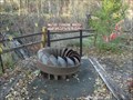
|   Water Turbine Wheel - Osceola Wisconsin Water Turbine Wheel - Osceola Wisconsin
in Signs of History Informational sign posted near old Water Wheel. posted by:  lenron lenron location: Wisconsin date approved: 11/12/2013 last visited: 03/17/2015 |
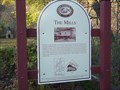 view gallery view gallerySW0.2 km | The Mills - Osceola, WI in Signs of History Small roadside park near Cascade Falls in Osceola, WI. posted by: lenron location: Wisconsin date approved: 11/26/2013 last visited: 03/17/2015 |
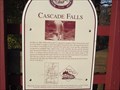 view gallery view gallerySW0.2 km | Cascade Falls - Osceola, WI in Signs of History Informational sign about the nearby Cascade Falls. posted by: lenron location: Wisconsin date approved: 11/26/2013 last visited: 03/17/2015 |
 view gallery view gallerySW0.2 km | Osceola, Wisconsin in Signs of History Wooden slat sign depicting the history of Osceola Wisconsin. posted by: lenron location: Wisconsin date approved: 11/13/2013 last visited: 03/17/2015 |
 view gallery view gallerySW0.2 km |  Chief Osceola - Osceola Wisconsin Chief Osceola - Osceola Wisconsin
in Statues of Historic Figures Folk art statue of Osceola's namesake, Chief Osceola. posted by: lenron location: Wisconsin date approved: 11/14/2013 last visited: 03/17/2015 |
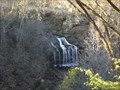 view gallery view gallerySW0.2 km |  Cascade Falls - Osceola, Wisconsin Cascade Falls - Osceola, Wisconsin
in Waterfalls Scenic Falls right in city of Osceola. posted by: lenron location: Wisconsin date approved: 11/08/2013 last visited: 03/17/2015 |
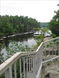
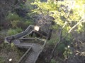 view gallery view gallerySW0.2 km |  Cascade Falls - Osceola, Wisconsin Cascade Falls - Osceola, Wisconsin
in Outdoor Stairways Nice wooden stairs down to the Osceola Creek and Cascade Waterfalls. posted by: lenron location: Wisconsin date approved: 11/09/2013 last visited: 03/17/2015 |
 view gallery view gallerySW4.7 km |  Standing Cedars Land Conservancy Standing Cedars Land Conservancy
in Public Access Lands The Standing Cedars Land Conservancy preserves this natural area for all to enjoy. The Buffalo Skull area is a 245-acre property, including dry cliffs, oak savanna, a moist ravine, maple/basswood forest, and former farm fields. posted by:  PaddlinMad PaddlinMad location: Wisconsin date approved: 05/31/2009 last visited: 05/30/2011 |
 view gallery view gallery N6.6 km N6.6 km
|  Franconia Cemetery, Taylors Falls, Minnesota Franconia Cemetery, Taylors Falls, Minnesota
in Worldwide Cemeteries Franconia Cemetery is located in Chisago County near Taylors Falls, Minnesota. posted by: deano1943 location: Minnesota date approved: 07/02/2012 last visited: 07/01/2012 |
 view gallery view galleryN6.8 km |  Franconia Sculpture Park - Franconia, MN Franconia Sculpture Park - Franconia, MN
in Sculpture Gardens The Franconia Sculpture Park, claimed to be the Midwest's premier outdoor sculpture park, is located about 45 minutes northeast of Minneapolis-St. Paul in Minnesota. posted by: Marine Biologist location: Minnesota date approved: 09/05/2009 last visited: 01/02/2023 |
 view gallery view gallery NE9.7 km NE9.7 km
|  State Park Movement in Wisconsin "Interstate Park" State Park Movement in Wisconsin "Interstate Park"
in Wisconsin Historical Markers State Park Movement in Wisconsin Marker in Interstate Park in St. Croix Falls. Marker is by the Visitor/Information building inside the park. posted by: frankhj location: Wisconsin date approved: 07/22/2007 last visited: 08/02/2003 |
 view gallery view galleryNE9.7 km |  First United Methodist Church First United Methodist Church
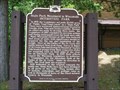
in Minnesota Historical Markers Methodist circuit riders of the Sunrise Mission served the Taylor's Falls area, 1852-59. March 27, 1859, the Rev. Sias Bolles, Presiding Elder, organized the Taylor's Falls Methodist Episcopal Church with 35 members. posted by: MNSearchers location: Minnesota date approved: 11/03/2007 last visited: 11/01/2013 |
 view gallery view galleryNE9.7 km |  OLDEST Methodist Church Building in Minnesota - Taylors Falls, MN OLDEST Methodist Church Building in Minnesota - Taylors Falls, MN
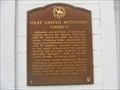
in Superlatives A sign outside this church states that this is the oldest Methodist Church building in continuous use in Minnesota. posted by: wildernessmama location: Minnesota date approved: 06/22/2013 last visited: 11/01/2013 |
 view gallery view galleryNE9.7 km |  Taylors Falls United Methodist Church, Taylor’s Falls, MN Taylors Falls United Methodist Church, Taylor’s Falls, MN
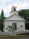
in Methodist Churches The sign outside this United Methodist Church tells about its history. posted by: wildernessmama location: Minnesota date approved: 06/22/2013 last visited: never |
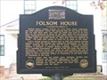 view gallery view galleryNE9.7 km | Folsom House in Minnesota Historical Markers W.H.C. Folsom on lumbering, 1845 posted by: MNSearchers location: Minnesota date approved: 11/03/2007 last visited: 11/01/2013 |
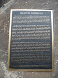 view gallery view galleryNE9.8 km | Glacial Pothole Historical Marker – Taylors Falls, MN in Minnesota Historical Markers This historical marker tells about the geological significance of this area. posted by: wildernessmama location: Minnesota date approved: 06/22/2013 last visited: 07/24/2012 |
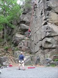 view gallery view galleryNE9.8 km |  Interstate Park Rock Climbing Area - Taylors Falls, MN Interstate Park Rock Climbing Area - Taylors Falls, MN
in Established Rock Climbing Areas There are eight popular spots for climbing rocks in Interstate State Park. posted by: wildernessmama location: Minnesota date approved: 06/23/2013 last visited: 07/27/2012 |
 view gallery view galleryNE9.8 km |  St. Croix National Scenic Riverway – Taylors Falls, MN St. Croix National Scenic Riverway – Taylors Falls, MN
in National Wild and Scenic Rivers Two signs at the Interstate State Park at Taylors Falls tell the significance of the St. Croix National Scenic Riverway and the importance of caring for this gem. posted by: wildernessmama location: Minnesota date approved: 06/21/2013 last visited: 04/20/2024 |
 view gallery view galleryNE9.8 km |  Interstate State Park WPA/Rustic Style Historic District - Taylors Park , MN Interstate State Park WPA/Rustic Style Historic District - Taylors Park , MN
in U.S. National Register of Historic Places These rustic stone buildings were the work of the WPA and are located at the parking lot of Interstate State Park. posted by: wildernessmama location: Minnesota date approved: 06/22/2013 last visited: 07/24/2012 |
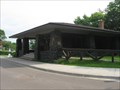 view gallery view galleryNE9.8 km |  Interstate State Park WPA Project– Taylors Falls, MN Interstate State Park WPA Project– Taylors Falls, MN
in WPA Projects These rustic stone buildings were the work of the WPA and are located at the parking lot of Interstate State Park. posted by: wildernessmama location: Minnesota date approved: 06/22/2013 last visited: 07/24/2012 |
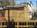
 view gallery view galleryNE9.8 km |  Old Jail Bed and Breakfast - Taylors Falls Minnesota Old Jail Bed and Breakfast - Taylors Falls Minnesota
in Bed and Breakfast Historic bed and breakfast located in historic Taylors Falls MN. posted by: lenron location: Minnesota date approved: 11/08/2013 last visited: never |
 view gallery view galleryNE9.8 km |  Adirondack Chair - Taylors Falls Minnesota Adirondack Chair - Taylors Falls Minnesota
in Ginormous Everyday Objects Giant Adirondack chair in the historic section of Taylor's Falls Minnesota. posted by: lenron location: Minnesota date approved: 11/15/2013 last visited: never |
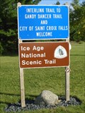 view gallery view galleryNE9.8 km |  Ice Age Trail - Interstate Park - St. Croix Falls, WI Ice Age Trail - Interstate Park - St. Croix Falls, WI
in Ice Age Trail The posted coordinates are for the Ice Age Trail sign at the entrance to Interstate Park in St. Croix Falls, Wisconsin. posted by: Marine Biologist location: Wisconsin date approved: 08/29/2009 last visited: 06/17/2013 |
 view gallery view galleryNE9.8 km | OLDEST Existing Public School House – Taylors Falls, MN in Superlatives A sign on Town House School claims that it is the oldest existing public school house in Minnesota. posted by: wildernessmama location: Minnesota date approved: 06/23/2013 last visited: 11/01/2013 |
 view gallery view galleryNE10.1 km |  Taylors Falls Landmark - Taylors Falls, MN Taylors Falls Landmark - Taylors Falls, MN
in Murals This painting of the Devil’s Chair formation on the St. Croix River is done in shades of gray resembing a newspaper photograph. posted by: wildernessmama location: Minnesota date approved: 06/28/2013 last visited: never |
|