 view gallery view gallery NE2.6 km NE2.6 km
|   Subway Store - Flying J Travel Center - Portland, OR Subway Store - Flying J Travel Center - Portland, OR
in Subway Restaurants This Subway is located in a truck stop travel center. posted by:  NW_history_buff NW_history_buff location: Oregon date approved: 01/04/2016 last visited: never |
 view gallery view galleryNE2.9 km |  Travel America Truckstop, Aurora, Oregon Travel America Truckstop, Aurora, Oregon
in Truck Stops This full service truck stop has easy access to Interstate 5. posted by: Queens Blessing location: Oregon date approved: 07/30/2011 last visited: 03/17/2014 |
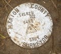
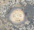 view gallery view gallery W3.2 km W3.2 km
|  Marion County T6S R2W Marion County T6S R2W
in U.S. Benchmarks In the middle of the intersection of Case Road and Yergen Road NE, in Marion County, Oregon is a new benchmark that I discovered while searching for RD2712. It is marked as "Marion County T6SR2W" posted by: MIG2 location: Oregon date approved: 05/14/2009 last visited: never |
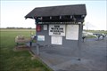 view gallery view gallery N4 km N4 km
|  Bob Watkins Memorial Field - Butteville, OR Bob Watkins Memorial Field - Butteville, OR
in Model Aircraft Fields The Portland Barnstormers club has an airfield near Butteville, Oregon. posted by: dkestrel location: Oregon date approved: 01/08/2014 last visited: 01/08/2014 |
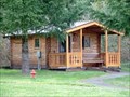 view gallery view gallery NW4.3 km NW4.3 km
|  Champoeg State Park Cabins - Newberg, OR Champoeg State Park Cabins - Newberg, OR
in Chalet, Cottage, and Cabin Style Lodging Champoeg park has a year round campground, group RV area with meeting hall, yurts and cabins. posted by: dkestrel location: Oregon date approved: 02/11/2014 last visited: 08/17/2014 |
 view gallery view galleryNW4.8 km |  Champoeg State Park Disc Golf - Newberg, OR Champoeg State Park Disc Golf - Newberg, OR
in Disc Golf Courses This course travels level terrain with tall, thick oaks. Good length and fair fairways. Vehicle fee; $3/day, $25/annual. posted by: dkestrel location: Oregon date approved: 11/27/2013 last visited: 08/16/2014 |
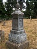 view gallery view galleryN5 km |  Gustavus A. Cone - Butteville Pioneer Cemetery, Butteville, OR, USA Gustavus A. Cone - Butteville Pioneer Cemetery, Butteville, OR, USA
in Zinc Headstones One of several zinc headstones in Butteville Pioneer Cemetery posted by: Prying Pandora location: Oregon date approved: 07/17/2007 last visited: 06/05/2010 |
 view gallery view galleryNW5.1 km |  Champoeg State Heritage Area - Newberg, Oregon Champoeg State Heritage Area - Newberg, Oregon
in State/Provincial Parks Champoeg is a former town in the U.S. state of Oregon. Now a ghost town, it was an important settlement in the Willamette Valley in the early 1840s. It is now preserved as Champoeg State Heritage Area as part of the Oregon State Parks system. posted by:  RickObst RickObst location: Oregon date approved: 08/24/2018 last visited: never |
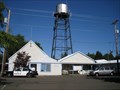
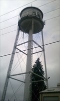 view gallery view gallery SE5.3 km SE5.3 km
|  Hubbard Water Tower - Hubbard, OR Hubbard Water Tower - Hubbard, OR
in Water Towers This water tower is located in the heart of the historic town of Hubbard at the corner of D St and Hwy 99. posted by: NW_history_buff location: Oregon date approved: 04/09/2013 last visited: 08/15/2016 |
 view gallery view gallerySE5.3 km |  Hubbard, Oregon 97032 Hubbard, Oregon 97032
in U.S. Post Offices Standard small stand alone in the small town of Hubbard. posted by: shadow101 location: Oregon date approved: 03/17/2009 last visited: 03/17/2009 |
 view gallery view galleryNW5.5 km | Marion County Surveyor T4S R2W SO2 9449 1994 in U.S. Benchmarks This mark is located just South of the fence to the Newell Residence Museum, next to Champoeg State Heritage Area. posted by: MIG2 location: Oregon date approved: 06/07/2009 last visited: never |
 view gallery view galleryNW5.5 km |  Robert Newell - St. Paul, OR Robert Newell - St. Paul, OR
in Homesteads Most of the town of Champoeg was located on the Donation Land Claims of Robert Newell and André Longtain. In 1843 Robert Newell was one who voted for the divide that established the Provisional government that led to Territorial status. posted by: dkestrel location: Oregon date approved: 02/12/2014 last visited: 02/12/2014 |
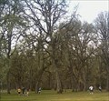
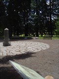
 view gallery view galleryNW5.8 km |  Champoeg - St. Paul, OR Champoeg - St. Paul, OR
in Remains of Settlements During the 1850s, Champoeg was a significant pioneer town of perhaps 200 people. While excavation is ongoing, there are stone markers showing where the town's street grid was. A map showing building locations is available in the guest center. posted by: dkestrel location: Oregon date approved: 02/28/2014 last visited: 08/17/2014 |
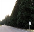 view gallery view gallery E6 km E6 km
|  Hwy 99 Redwoods, Aurora, Oregon Hwy 99 Redwoods, Aurora, Oregon
in Sequoioideae Trees These trees are actually located between two cities: Aurora and Hubbard, Oregon. posted by: Queens Blessing location: Oregon date approved: 08/05/2011 last visited: 09/15/2012 |
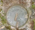
 view gallery view galleryNW6 km | Oregon State Hwy Dept. BM ZON in U.S. Benchmarks Major benchmark on South Boundary of Champoeg State Heritage Area (Park) posted by: MIG2 location: Oregon date approved: 08/20/2010 last visited: never |
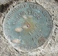
 view gallery view galleryNW6.1 km | State Highway Department BM No 10 LK Elev 935 FEET in U.S. Benchmarks Mounted on a concrete Pedestal with the disk bearing the inscription "State Highway Department BM No" posted by: MIG2 location: Oregon date approved: 05/22/2009 last visited: never |
 view gallery view galleryNW6.3 km |  Champoeg Oregon Champoeg Oregon
in Ghost Towns Champoeg (shampoo-ee) was destroyed by a flood in December of 1861. It is now a State Park. posted by: TheBeanTeam location: Oregon date approved: 12/01/2006 last visited: 11/22/2013 |
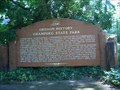
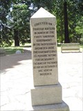 view gallery view galleryNW6.3 km |  FIRST - American Government on the Pacific Coast FIRST - American Government on the Pacific Coast
in First of its Kind Champoeg Oregon, May 2nd, 1843 a vote was held at this spot to form the first provisional government in the far west. posted by: TheBeanTeam location: Oregon date approved: 12/01/2006 last visited: 09/11/2012 |
 view gallery view galleryE6.3 km |  Pacific Hazelnut Candy Factory Tour - Aurora, Oregon Pacific Hazelnut Candy Factory Tour - Aurora, Oregon
in Factory Tours If you love candy and you love nuts then this tour will be something you certainly won't want to miss! posted by: Rose Red location: Oregon date approved: 10/14/2011 last visited: 06/06/2020 |
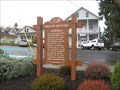
 view gallery view galleryNW6.3 km |  Champoeg State Park Champoeg State Park
in Oregon Historical Markers Beaver Board Marker in Champoeg State Park posted by: Prying Pandora location: Oregon date approved: 07/17/2007 last visited: 10/03/2007 |
 view gallery view galleryE6.6 km |  Aurora, Oregon Aurora, Oregon
in City and Town Halls The City Hall Building, Aurora, Oregon posted by: ddtfamily location: Oregon date approved: 08/20/2012 last visited: never |
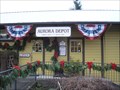 view gallery view galleryE6.6 km |  Southern Pacific Railroad Depot - Aurora, Oregon Southern Pacific Railroad Depot - Aurora, Oregon
in Train Stations/Depots The Aurora Depot is today an antiques and lamp store. The building was moved about 100 feet away from the railroad. posted by: Bluejacket01 location: Oregon date approved: 02/22/2009 last visited: 12/06/2009 |
 view gallery view galleryE6.6 km | Aurora, Oregon History Board in Oregon Historical Markers This "Beaver" Board is right in the middle of the town of Aurora. posted by: Queens Blessing location: Oregon date approved: 12/07/2009 last visited: 12/31/2012 |
 view gallery view galleryE6.6 km |  Aurora Colony Auction House, Aurora, Oregon Aurora Colony Auction House, Aurora, Oregon
in Auction Houses Aurora, Oregon is known as a town that specializes in antiques, making it a perfect place for an auction house. posted by: Queens Blessing location: Oregon date approved: 02/16/2013 last visited: 02/17/2013 |
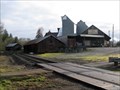 view gallery view galleryE6.8 km |  Aurora Mills Architectural Salvage, Aurora, Oregon Aurora Mills Architectural Salvage, Aurora, Oregon
in Grain Elevators This one-time grain elevator is now the location for salvaged building materials. posted by: Queens Blessing location: Oregon date approved: 02/26/2013 last visited: 03/03/2013 |
|