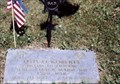
 view gallery view gallery E6.4 km E6.4 km
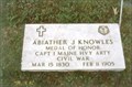
|   Abiather J. Knowles-Lagrange, ME Abiather J. Knowles-Lagrange, ME
in Medal Of Honor Resting Places Civil War Medal of Honor Recipient for action at Bull Run, VA on July 21, 1861. He is buried in Hill Crest Cemetery, Lagrange, ME. posted by:  Don.Morfe Don.Morfe location: Maine date approved: 10/28/2018 last visited: 12/08/2021 |
 view gallery view galleryE22.2 km |  West Enfield Cemetery - West Enfield, Maine West Enfield Cemetery - West Enfield, Maine
in Worldwide Cemeteries West Enfield Cemetery is about 2.5 km south of West Enfield on Hwy. 2./Main Road. posted by:  T0SHEA T0SHEA location: Maine date approved: 10/19/2015 last visited: never |
 view gallery view gallery SE23.8 km SE23.8 km
|  04418 - Greenbush, Maine 04418 - Greenbush, Maine
in U.S. Post Offices The Greenbush Post Office is in a small rural community and is located on US Hwy. 2 about 8 miles north of Greenbush. posted by: Tante.Hossi location: Maine date approved: 10/01/2015 last visited: never |
 view gallery view galleryE25.1 km | Weld Cemetery - Greenbush, Maine in Worldwide Cemeteries Weld Cemetery is on Military Road near the exit off of Main Road/Hwy. 2, about 250 metres NW on Military Road. posted by: T0SHEA location: Maine date approved: 10/14/2015 last visited: never |
 view gallery view gallery S26.2 km S26.2 km
|  Robyville Bridge Robyville Bridge
in Covered Bridges Only fully shingled covered bridge in Maine posted by: CoveredBridgeGuy location: Maine date approved: 12/03/2006 last visited: 04/16/2013 |
 view gallery view gallerySE28.8 km | Costigan Cemetery - Milford, Maine in Worldwide Cemeteries Costigan Cemetery is located on Main Street/Hwy. 2 just south of Greenfield Road. posted by: T0SHEA location: Maine date approved: 10/14/2015 last visited: never |
 view gallery view galleryS29.5 km |  Coca Cola Silo - Kenduskeag ME Coca Cola Silo - Kenduskeag ME
in Coca Cola Memorabilia Located on Rt 15 (Broadway) posted by: nomadwillie location: Maine date approved: 10/01/2015 last visited: never |
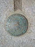
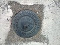 view gallery view gallerySE30.6 km |  PREB-1 1982 - Old Town, Maine PREB-1 1982 - Old Town, Maine
in U.S. Benchmarks PREB-1 is a Maine Department of Transportation Survey Control Marker located at the intersection of Bennoch Road and Gilman Falls Avenue. posted by: UMainah location: Maine date approved: 11/15/2013 last visited: 09/01/2012 |
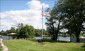
 view gallery view gallery W30.9 km W30.9 km
| Lowe's Bridge in Covered Bridges This one has a very unique floor - Parts of it lift up for shoveling snow down into the river. posted by: CoveredBridgeGuy location: Maine date approved: 12/03/2006 last visited: 07/13/2023 |
 view gallery view galleryW30.9 km |  Lowe's Bridge - Guilford ME Lowe's Bridge - Guilford ME
in Truss Bridges The bridge has a clear span of 120 feet over the Piscataquis River. It is located just off State Route 15 south of Guilford Village. Long through truss bridge over Piscataquis River on Lowes Bridge Road. posted by: nomadwillie location: Maine date approved: 10/01/2015 last visited: 07/13/2023 |
 view gallery view galleryW30.9 km |  Lowe's Bridge - Guilford ME Lowe's Bridge - Guilford ME
in Plank Roads This bridge, built in 1857, was washed away by the flood of April 1, 1987. A modern covered bridge, patterned after the original, was built on the original abutments in 1990. posted by: nomadwillie location: Maine date approved: 10/01/2015 last visited: 07/13/2023 |
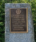 view gallery view galleryW30.9 km |  Low's Bridge - Guilford ME Low's Bridge - Guilford ME
in Maine Historical Markers This bridge, built in 1857, was washed away by the flood of April 1, 1987. A modern covered bridge, patterned after the original, was built on the original abutments in 1990. posted by: nomadwillie location: Maine date approved: 10/01/2015 last visited: 07/13/2023 |
 view gallery view galleryS32.8 km |  Vietnam War Memorial, Nadeau - Savoy Memorial Park, Orono, ME, USA Vietnam War Memorial, Nadeau - Savoy Memorial Park, Orono, ME, USA
in Vietnam War Memorials A community sponsored memorial honoring 2 Orono men who lost their lives in the Vietnam War, Clayton Savoy, and Larry Nadeau. posted by: HANSENNI location: Maine date approved: 09/01/2011 last visited: never |
 view gallery view gallery SW33.3 km SW33.3 km
| Otis O. Roberts-Dexter, ME in Medal Of Honor Resting Places Civil War Medal of Honor Recipient for action at Rappanhannock Station, VA on November 7, 1863. He is buried in Mount Pleasant Cemetery, Dexter, ME posted by: Don.Morfe location: Maine date approved: 04/16/2019 last visited: 12/05/2021 |
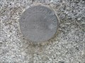
 view gallery view gallerySE33.6 km | D 133 RESET 1978 - Old Town, Maine in U.S. Benchmarks National Geodetic Survey Vertical Control Mark marked as D 133 RESET 1978. posted by: UMainah location: Maine date approved: 11/16/2013 last visited: 04/26/2011 |
 view gallery view gallerySE34 km |  Milford Dam - Milford, Maine Milford Dam - Milford, Maine
in Water Dams The Milford Dam spans the Penobscot River from Milford, Maine to Old Town, Maine. posted by: UMainah location: Maine date approved: 04/22/2014 last visited: 04/20/2014 |
 view gallery view gallerySE34.4 km | Lawndale Cemetery - Old Town, ME in Worldwide Cemeteries Lawndale Cemetery on Stillwater ave in Old Town. posted by: RIclimber location: Maine date approved: 03/12/2010 last visited: 03/13/2010 |
 view gallery view gallerySE34.6 km | S 84 1942 - Old Town, Maine in U.S. Benchmarks U.S. Coast & Geodetic Survey Benchmark marked with S 84, monumented in 1942 at the Old Town Post Office. posted by: UMainah location: Maine date approved: 11/16/2013 last visited: 05/11/2012 |
 view gallery view gallerySE34.6 km | 108 BANGOR - Old Town, Maine in U.S. Benchmarks U.S. Geological Survey Bench Mark Disk marked with 108 BANGOR and was monumented in 1900. posted by: UMainah location: Maine date approved: 11/16/2013 last visited: 05/11/2012 |
 view gallery view gallerySE34.9 km |  Old Town Railway Station - Old Town, Maine Old Town Railway Station - Old Town, Maine
in Photos Then and Now This depot stands beside the state's first railway, completed in 1836. posted by: T0SHEA location: Maine date approved: 11/13/2023 last visited: never |
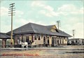 view gallery view gallerySE34.9 km |  Old Town Railway Station - Old Town, Maine Old Town Railway Station - Old Town, Maine
in Picture Perfect Postcards This depot stands beside the state's first railway, completed in 1836. posted by: T0SHEA location: Maine date approved: 11/13/2023 last visited: never |
 view gallery view gallerySE34.9 km |  Old Town Station - Old Town, ME Old Town Station - Old Town, ME
in Train Stations/Depots This depot stands beside the state's first railway, completed in 1836. posted by: T0SHEA location: Maine date approved: 09/07/2016 last visited: never |
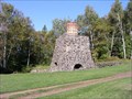 view gallery view gallery NW35.9 km NW35.9 km
|  Katahdin Iron Works Katahdin Iron Works
in Iron Furnace Ruins Built in the 1800's posted by: Haffy location: Maine date approved: 10/02/2005 last visited: 10/11/2009 |
 view gallery view gallerySE36 km | Forest Hill Cemetery - Old Town, Maine in Worldwide Cemeteries Forest Hill Cemetery is a very large cemetery and is still in use. It is located on Main Street/Hwy. 2 about 1 mile south of downtown Old Town. posted by: T0SHEA location: Maine date approved: 10/12/2015 last visited: never |
 view gallery view gallerySW36.2 km | Stetson, ME 04488 in U.S. Post Offices Located on Stetson Rd in Stetson posted by: nomadwillie location: Maine date approved: 06/09/2013 last visited: never |
|