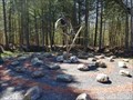
 view gallery view gallery E2.7 km E2.7 km
|   Labyrinthe du Hibou-Potton-Qc,Canada Labyrinthe du Hibou-Potton-Qc,Canada
in Labyrinths Un beau labyrinthe dans la halte! un beautiful labyrinth at the halt! posted by:  gemeloj gemeloj location: Québec, Canada date approved: 05/30/2018 last visited: 06/23/2021 |
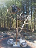 view gallery view galleryE2.7 km |  Le Hibou de Potton- Québec,Canada Le Hibou de Potton- Québec,Canada
in Figurative Public Sculpture Hibou volant au-dessus de son nid! an Owl soaring over the nest! posted by: gemeloj location: Québec, Canada date approved: 05/28/2018 last visited: 06/23/2021 |
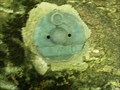
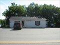
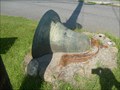 view gallery view gallery S2.9 km S2.9 km
|  Cloche de l'église de Mansonville,Qc Cloche de l'église de Mansonville,Qc
in Bells La cloche de l'église de Masonville posted by: SCALAIRE location: Québec, Canada date approved: 08/08/2011 last visited: 08/27/2020 |
 view gallery view galleryS3.2 km |  Capsule temps, Potton, Mansonville Qc Capsule temps, Potton, Mansonville Qc
in Community Commemoration Capsule temps de Potton (Mansonville) posted by: SCALAIRE location: Québec, Canada date approved: 08/12/2011 last visited: 11/07/2021 |
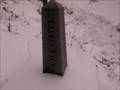
 view gallery view gallery W5 km W5 km
|  Borne géodésique NG7550 Borne géodésique NG7550
in Canadian Benchmarks Borne géodésique NG7550 portant le sigle d'Hydro Québec sur le chemin de l'étang Fullerton. posted by: nobellium location: Québec, Canada date approved: 07/12/2012 last visited: 06/23/2021 |
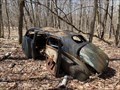 view gallery view gallery NW5.6 km NW5.6 km
|  Ford - Mansonville, Qc, CANADA Ford - Mansonville, Qc, CANADA
in Abandoned Dead Vehicles Un vieux Ford dans la Réserve naturelle des Montagnes-Vertes (RNMV).
An old Ford found in la Réserve naturelle des Montagnes-Vertes (RNMV). posted by: mcmeunier location: Québec, Canada date approved: 05/02/2022 last visited: 09/17/2022 |
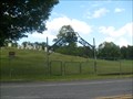
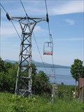 view gallery view galleryE6.8 km |  Aerial lift - Owls Head, Station, Qc, Canada Aerial lift - Owls Head, Station, Qc, Canada
in Aerial Lifts Owls Head Ski Station in Quebec, Canada - Station de sli Owls Head, Quebec. posted by: Ourspolaire&Gemeloj location: Québec, Canada date approved: 06/13/2012 last visited: 10/13/2022 |
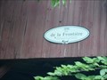
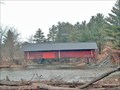
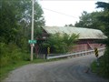 view gallery view galleryS7.2 km |  Pont de la Frontière Canton Potton (Masonville) Qc Pont de la Frontière Canton Potton (Masonville) Qc
in Covered Bridges Pont couvert De La Frontière posted by: SCALAIRE location: Québec, Canada date approved: 08/11/2011 last visited: 06/21/2021 |
 view gallery view galleryS7.2 km | ") Pont de la frontière, Potton (Masonville) Qc Pont de la frontière, Potton (Masonville) Qc
in Histoire du Quebec (Quebec Historical Markers) Pont Couvert sur le Chemin Bellevue posted by: SCALAIRE location: Québec, Canada date approved: 08/09/2011 last visited: 06/22/2021 |
 view gallery view gallery NE8.7 km NE8.7 km
|  Cimetière George,Knowlton,Qc Cimetière George,Knowlton,Qc
in Worldwide Cemeteries Cimetière familialle George posted by: SCALAIRE location: Québec, Canada date approved: 08/15/2011 last visited: 07/16/2021 |
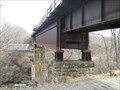 view gallery view galleryS9.2 km |  High Bridge - North Troy, Vermont High Bridge - North Troy, Vermont
in Railroad Bridges Still active international line posted by:  Vermontish Vermontish location: Vermont date approved: 03/27/2010 last visited: 11/27/2016 |
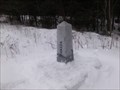 view gallery view gallery SW9.2 km SW9.2 km
| Borne frontière Canada - USA Chemin du Pipeline, Potton, Qc in Canadian Benchmarks Borne frontière Canada- USA Chemin du Pipeline, Potton. Qc posted by: nobellium location: Québec, Canada date approved: 01/25/2012 last visited: 10/24/2023 |
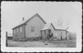
 view gallery view galleryS9.2 km |  North Troy, Vermont 05859 North Troy, Vermont 05859
in U.S. Post Offices Can you spot something unusual in the pictures? posted by: Vermontish location: Vermont date approved: 07/18/2008 last visited: 11/27/2016 |
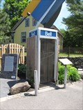 view gallery view gallery N9.3 km N9.3 km
|  Payphone of Bolton-Sud, QC Payphone of Bolton-Sud, QC
in Payphones Un téléphone payant a Bolton Pass! A payphone in Bolton Pass, Qc posted by: Ourspolaire&Gemeloj location: Québec, Canada date approved: 06/20/2012 last visited: 06/29/2021 |
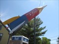 view gallery view galleryN9.3 km |  The rocket of Jean-Claude Labranche, South Bolton, Qc The rocket of Jean-Claude Labranche, South Bolton, Qc
in Realistic Object Sculptures A rocket for the love of Appolo! posted by: Ourspolaire&Gemeloj location: Québec, Canada date approved: 06/13/2012 last visited: 11/15/2022 |
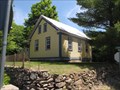 view gallery view galleryN9.3 km |  Red Schoold House, Bolton-Sud, Qc Red Schoold House, Bolton-Sud, Qc
in Former Schools The Red School house of Bolton-South a former road School. posted by: Ourspolaire&Gemeloj location: Québec, Canada date approved: 06/13/2012 last visited: 06/29/2021 |
 view gallery view galleryN9.3 km |  Former Red School house - Bolton-Sud, Qc, Canada Former Red School house - Bolton-Sud, Qc, Canada
in Photos Then and Now A picture of the Red School house in 1940 compared to today. posted by: Ourspolaire&Gemeloj location: Québec, Canada date approved: 06/13/2012 last visited: 06/29/2021 |
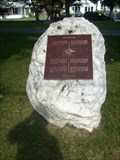
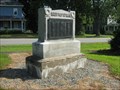 view gallery view galleryS9.5 km |  Civil War Memorial - North Troy, Vermont Civil War Memorial - North Troy, Vermont
in American Civil War Monuments and Memorials G.A.R. Memorial posted by: Vermontish location: Vermont date approved: 07/18/2008 last visited: 11/27/2016 |
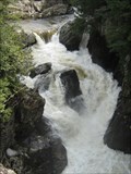 view gallery view galleryS11.6 km |  Big Falls - Troy, Vermont Big Falls - Troy, Vermont
in Waterfalls Centerpiece of a minor state park posted by: Vermontish location: Vermont date approved: 03/26/2010 last visited: never |
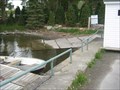 view gallery view galleryNE11.9 km |  Boat Ramp,Georgeville, QC, Canada Boat Ramp,Georgeville, QC, Canada
in Boat Ramps A great boat ramp situated in Georgeville,QC, on the shore of Lake Memphremagog. posted by: stonefly626 location: Québec, Canada date approved: 05/17/2013 last visited: 07/17/2021 |
 view gallery view gallery SE12.4 km SE12.4 km
| Borne frontière Canada - USA Chemin Leadville in Canadian Benchmarks Borne frontière Canada - USA Chemin Leadville,Qc posted by: nobellium location: Québec, Canada date approved: 01/12/2012 last visited: 10/12/2014 |
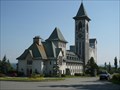 view gallery view galleryNE13 km |  Abbaye St-Benoît - Saint-Benoît-du-Lac, QC, Canada Abbaye St-Benoît - Saint-Benoît-du-Lac, QC, Canada
in Abbeys, Convents and Monasteries Lieu de silence et de recueillement / Place of silence and meditation posted by: Zubulus location: Québec, Canada date approved: 04/13/2014 last visited: 05/31/2021 |
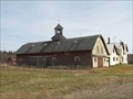 view gallery view galleryS13.5 km |  Veilleux Road - Troy, Vermont Veilleux Road - Troy, Vermont
in Barns Pass by here on your way to the covered bridge posted by: Vermontish location: Vermont date approved: 03/27/2010 last visited: never |
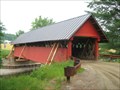 view gallery view galleryS13.5 km |  River Road Covered Bridge - Troy, Vermont River Road Covered Bridge - Troy, Vermont
in U.S. National Register of Historic Places The only covered bridge in Troy posted by: Vermontish location: Vermont date approved: 07/13/2008 last visited: 07/01/2009 |
 view gallery view galleryS13.5 km | River Road Bridge in Covered Bridges This bridge incorporates a lightweight version of the Town Lattice Truss. The bridge is also the northernmost covered bridge in Vermont, being only a couple of miles from Canada. posted by: CoveredBridgeGuy location: Vermont date approved: 01/08/2007 last visited: 08/07/2010 |
|