 view gallery view gallery W7.2 km W7.2 km
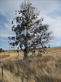
|   Shaniko Oregon Shoe Tree Shaniko Oregon Shoe Tree
in Shoe Trees A well used and well loved shoe tree near Shaniko, Oregon. posted by:  Queens Blessing Queens Blessing location: Oregon date approved: 12/07/2008 last visited: 12/16/2013 |
 view gallery view gallery SW11.4 km SW11.4 km
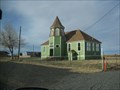
|  Shaniko Jail – Shaniko, Oregon Shaniko Jail – Shaniko, Oregon
in Retired Prisons This jail is original to the town, built in 1901 and restored a few years later. posted by:  wildernessmama wildernessmama location: Oregon date approved: 12/24/2017 last visited: never |
 view gallery view gallerySW11.4 km |  S.F.D. Fire House S.F.D. Fire House
in Firehouses Small firehouse in Shaniko, Oregon. posted by: Volcanoguy location: Oregon date approved: 11/19/2006 last visited: 06/15/2017 |
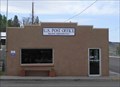
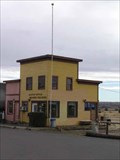 view gallery view gallerySW11.6 km |  Shaniko, OR, 97057 Shaniko, OR, 97057
in U.S. Post Offices The Shaniko Post Office. posted by: Volcanoguy location: Oregon date approved: 11/01/2006 last visited: 06/15/2017 |
 view gallery view gallerySW11.6 km |  Shaniko Oregon, Lonesome Oregon Ghost Town Shaniko Oregon, Lonesome Oregon Ghost Town
in News Article Locations An article appeared in the New York Times about Shaniko, the Ghost Town in Oregon that was purchased by a philanthropist. posted by: Queens Blessing location: Oregon date approved: 08/07/2009 last visited: 06/15/2017 |
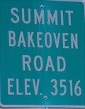 view gallery view galleryW15.3 km |  3516 Feet, Summit Bakeoven Road - OR 3516 Feet, Summit Bakeoven Road - OR
in Elevation Signs Summit sign on Bakeoven Road. posted by: Volcanoguy location: Oregon date approved: 07/17/2009 last visited: 05/08/2010 |
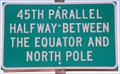 view gallery view galleryW15.6 km |  45th Parallel Sign near Shaniko, OR 45th Parallel Sign near Shaniko, OR
in Great Lines of Earth Sign along U.S. Hwy. 97 west of Shaniko, Oregon. posted by: Volcanoguy location: Oregon date approved: 09/21/2009 last visited: 11/27/2020 |
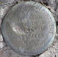
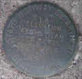
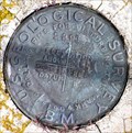
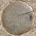 view gallery view galleryW15.6 km |  RC0452 - OSHD S3, Oregon RC0452 - OSHD S3, Oregon
in U.S. Benchmarks Oregon State Highway Department benchmark S3. posted by: Volcanoguy location: Oregon date approved: 01/28/2010 last visited: 05/08/2010 |
 view gallery view gallery N17.4 km N17.4 km
| Kent, OR, 97733 in U.S. Post Offices The Kent, OR Post Office. posted by: Volcanoguy location: Oregon date approved: 04/30/2007 last visited: 05/08/2010 |
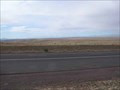 view gallery view galleryW19.2 km |  Shaniko Mountain Finder, Oregon Shaniko Mountain Finder, Oregon
in Scenic Roadside Look-Outs The Shaniko Mountain Finder Viewpoint is located on U.S. Hwy. 97 about 5 miles west of the community of Shaniko. posted by: Volcanoguy location: Oregon date approved: 11/10/2006 last visited: 05/08/2010 |
 view gallery view galleryN20 km |  Kent IOOF Cemetery, OR Kent IOOF Cemetery, OR
in Worldwide Cemeteries Small Sherman County community cemetery. posted by: Volcanoguy location: Oregon date approved: 05/01/2007 last visited: 05/08/2010 |
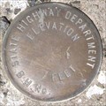
 view gallery view gallerySW30.1 km | ODOT S10, Oregon in U.S. Benchmarks Benchmark near Cow Canyon Rest Area posted by: Volcanoguy location: Oregon date approved: 05/28/2007 last visited: 05/08/2010 |
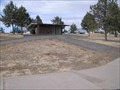 view gallery view gallerySW30.1 km |  Cow Canyon Rest Area, Oregon Cow Canyon Rest Area, Oregon
in Highway Rest Areas The Cow Canyon Rest Area on U.S. Hwy. 97. posted by: Volcanoguy location: Oregon date approved: 11/04/2006 last visited: 06/15/2017 |
 view gallery view galleryW30.1 km | 3360 Feet, Criterion Summit - OR in Elevation Signs Summit sign at Criterion Summit on U.S. Hwy. 197. posted by: Volcanoguy location: Oregon date approved: 07/13/2009 last visited: 05/08/2010 |
 view gallery view galleryW30.1 km | Criterion Summit Mountain Finder - OR in Scenic Roadside Look-Outs The Criterion Summit Mountain Finder Viewpoint is located on U.S. Hwy. 197 about 16 miles south of Maupin. posted by: Volcanoguy location: Oregon date approved: 07/19/2009 last visited: 05/08/2010 |
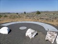
 view gallery view gallerySW30.1 km |  LEGACY - Cow Canyon Rest Area, Shaniko, OR LEGACY - Cow Canyon Rest Area, Shaniko, OR
in Blue Star Memorial Highway Markers Former site of a Blue Star Memorial Highway Marker at the Cow Canyon Rest Area. posted by: Volcanoguy location: Oregon date approved: 11/04/2006 last visited: 06/15/2017 |
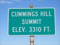 view gallery view gallery E33 km E33 km
| Cummings Hill Summit - 3310' in Elevation Signs A high point on Highway 19 between Fossil and Condon, Oregon. posted by: WR7X location: Oregon date approved: 09/25/2011 last visited: never |
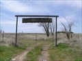
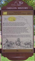 view gallery view galleryN37.5 km |  Oregon Trail Cutoff to the Barlow Road Oregon Trail Cutoff to the Barlow Road
in Oregon Historical Markers Beaver Board - Oregon History - Oregon Trail Cutoff to the Barlow Road posted by: Volcanoguy location: Oregon date approved: 11/05/2006 last visited: 06/15/2017 |
 view gallery view galleryW38.6 km | RC1108 - T16, Oregon in U.S. Benchmarks NGS PID RC1108 - T16 posted by: Volcanoguy location: Oregon date approved: 05/28/2007 last visited: 06/30/2008 |
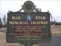
 view gallery view galleryW38.6 km | U.S. Hwy 197, Maupin - OR in Blue Star Memorial Highway Markers This Blue Star Memorial Highway Marker is located just north of the Deschutes River bridge in Maupin, OR. posted by: Volcanoguy location: Oregon date approved: 07/17/2009 last visited: 05/02/2010 |
 view gallery view galleryW38.9 km |  Great Railroad Race, Maupin, Oregon Great Railroad Race, Maupin, Oregon
in Murals Mural on building across street from Maupin Post Office. posted by: Volcanoguy location: Oregon date approved: 05/29/2007 last visited: 06/30/2008 |
 view gallery view galleryW38.9 km | Maupin, OR, 97037 in U.S. Post Offices The Maupin, OR Post Office. posted by: Volcanoguy location: Oregon date approved: 05/27/2007 last visited: 07/18/2008 |
 view gallery view galleryN39.6 km | RC0427 - 2391 H, Oregon in U.S. Benchmarks NGS PID RC0427 - 2391 H posted by: Volcanoguy location: Oregon date approved: 05/01/2007 last visited: 05/08/2010 |
 view gallery view galleryN39.6 km | Grass Valley IOOF Cemetery, OR in Worldwide Cemeteries Small Sherman County community cemetery. posted by: Volcanoguy location: Oregon date approved: 05/01/2007 last visited: 05/08/2010 |
 view gallery view gallery NW39.9 km NW39.9 km
| OSHD BM at Buck Hollow Bridge, Oregon in U.S. Benchmarks Blank benchmark on the bridge across Buck Hollow Creek. posted by: Volcanoguy location: Oregon date approved: 08/01/2009 last visited: 05/02/2010 |
|