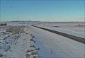
 view gallery view gallery SE6.1 km SE6.1 km
|   Biddle Northwest Webcam - Biddle, MT Biddle Northwest Webcam - Biddle, MT
in Web Cameras This is one of 73 (as of January 2017) Road Weather Information System cameras operated by the Montana Department of Transportation to aid motorists as they make their way across BIG SKY Country. posted by:  T0SHEA T0SHEA location: Montana date approved: 01/10/2017 last visited: never |
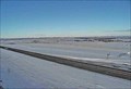 view gallery view gallerySE6.1 km | Biddle North Webcam - Biddle, MT in Web Cameras This is one of 73 (as of January 2017) Road Weather Information System cameras operated by the Montana Department of Transportation to aid motorists as they make their way across BIG SKY Country. posted by: T0SHEA location: Montana date approved: 01/10/2017 last visited: never |
 view gallery view gallerySE6.1 km | Biddle Roadway Webcam - Biddle, MT in Web Cameras This is one of 73 (as of January 2017) Road Weather Information System cameras operated by the Montana Department of Transportation to aid motorists as they make their way across BIG SKY Country. posted by: T0SHEA location: Montana date approved: 01/10/2017 last visited: never |
 view gallery view gallerySE6.1 km | Biddle Southeast Webcam - Biddle, MT in Web Cameras This is one of 73 (as of January 2017) Road Weather Information System cameras operated by the Montana Department of Transportation to aid motorists as they make their way across BIG SKY Country. posted by: T0SHEA location: Montana date approved: 01/10/2017 last visited: never |
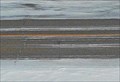
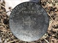 view gallery view gallery S36.9 km S36.9 km
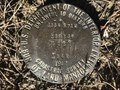
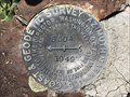
|  T55N R71W S26 S25 S36 S35 - Campbell County, Wyoming T55N R71W S26 S25 S36 S35 - Campbell County, Wyoming
in Public Land Survey Marks This USDI-Bureau of Land Management section corner marker is located in northern Campbell County. posted by: Tom.dog location: Wyoming date approved: 02/25/2023 last visited: never |
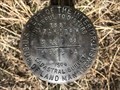
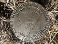
 view gallery view galleryS37 km | T55N R71W S25 S36 1/4 - Campbell County, Wyoming in Public Land Survey Marks A USDI-Bureau of Land Management quarter corner marker in northern Campbell County. posted by: Tom.dog location: Wyoming date approved: 02/25/2023 last visited: never |
 view gallery view galleryS37.2 km | T55N R71W S25 S36 R70W S30 S31 - Campbell County, Wyoming in Public Land Survey Marks This USDI-Bureau of Land Management section corner marker in located along the western boundary of Thunder Basin National Grassland. posted by: Tom.dog location: Wyoming date approved: 02/25/2023 last visited: never |
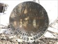 view gallery view galleryS37.3 km | T55N R70W S30 S31 1/4 - Campbell County, Wyoming in Public Land Survey Marks A USDI-Bureau of Land Management quarter corner marker in Thunder Basin National Grassland. posted by: Tom.dog location: Wyoming date approved: 02/25/2023 last visited: never |
 view gallery view galleryS37.5 km | T55N R70W S30 S29 S32 S31 - Campbell County, Wyoming in Public Land Survey Marks A USDI-Bureau of Land Management section corner marker in Thunder Basin National Grassland. posted by: Tom.dog location: Wyoming date approved: 02/25/2023 last visited: never |
 view gallery view galleryS37.7 km | T55N R71W S35 S36 1/4 - Campbell County, Wyoming in Public Land Survey Marks A USDI-Bureau of Land Management quarter corner marker in northern Campbell County. posted by: Tom.dog location: Wyoming date approved: 02/25/2023 last visited: never |
 view gallery view galleryS38.3 km | T55N R71W S35 S36 T54N S2 S1 - Campbell County, Wyoming in Public Land Survey Marks This USDI-Bureau of Land Management section corner marker is set near the eastern bank of the Little Powder River in northern Campbell County. posted by: Tom.dog location: Wyoming date approved: 02/25/2023 last visited: never |
 view gallery view galleryS38.5 km | T55N R71W S36 T54N S1 1/4 - Campbell County, Wyoming in Public Land Survey Marks This USDI-Bureau of Land Management quarter corner marker is located in northern Campbell County. posted by: Tom.dog location: Wyoming date approved: 02/25/2023 last visited: never |
 view gallery view galleryS38.8 km | T55N R71W S36 R70W S31 T54N R71W S1 R70W S6 - Campbell County, Wyoming in Public Land Survey Marks This township corner is located in northern Campbell County. posted by: Tom.dog location: Wyoming date approved: 02/25/2023 last visited: never |
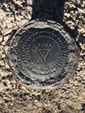
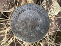
 view gallery view galleryS40.2 km |  SODA NO 2 - Campbell County, Wyoming SODA NO 2 - Campbell County, Wyoming
in U.S. Benchmarks Reference mark 2 for triangulation station SODA (PV0541). posted by: Tom.dog location: Wyoming date approved: 01/08/2023 last visited: never |
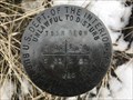
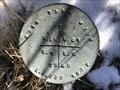
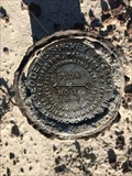
 view gallery view galleryS40.2 km | SODA (PV0541) - Campbell County, Wyoming in U.S. Benchmarks This triangulation station is located atop a hill in Thunder Basin National Grassland. posted by: Tom.dog location: Wyoming date approved: 01/08/2023 last visited: never |
 view gallery view galleryS40.2 km | SODA NO 1 - Campbell County, Wyoming in U.S. Benchmarks Reference mark 1 for triangulation station SODA (PV0541). posted by: Tom.dog location: Wyoming date approved: 01/08/2023 last visited: never |
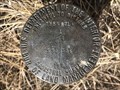
 view gallery view galleryS40.9 km | T54N R70W S4 S3 1/4 - Campbell County, Wyoming in Public Land Survey Marks A USDI-Bureau of Land Management quarter corner marker on Thunder Basin National Grassland. posted by: Tom.dog location: Wyoming date approved: 12/23/2022 last visited: never |
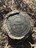
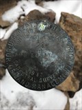
 view gallery view galleryS41 km | SODA Azimuth Mark - Campbell County, Wyoming in U.S. Benchmarks This is the elusive azimuth mark for triangulation station SODA (PV0541). posted by: Tom.dog location: Wyoming date approved: 07/02/2023 last visited: never |
 view gallery view galleryS41 km |  SODA Azimuth Mark - Campbell County, Wyoming SODA Azimuth Mark - Campbell County, Wyoming
in Azimuth Benchmarks Azimuth mark for triangulation station SODA (PV0541). posted by: Tom.dog location: Wyoming date approved: 07/02/2023 last visited: never |
 view gallery view gallery NE41.5 km NE41.5 km
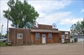
|  Boyes, Montana 59316 Boyes, Montana 59316
in U.S. Post Offices This Post Office is located at 10203 Highway 212 in Boyes, Montana. posted by: brwhiz location: Montana date approved: 02/05/2013 last visited: never |
 view gallery view galleryNE41.5 km |  Vacant Business Wagon Wheels Vacant Business Wagon Wheels
in Wagon Wheels These Wagon Wheels adorn the false front of a vacant business next to the post office at 10203 Highway 212 in Boyes, Montana. posted by: brwhiz location: Montana date approved: 02/24/2013 last visited: never |
 view gallery view gallerySE42.8 km | T54N R70W S1 R69W S6 1/4 - Campbell County, Wyoming in Public Land Survey Marks This USDI-Bureau of Land Management quarter corner marker is located a short distance to the south of Heald Road in Thunder Basin National Grassland. posted by: Tom.dog location: Wyoming date approved: 01/20/2023 last visited: never |
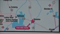
 view gallery view gallery N43 km N43 km
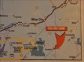
|  Broadus Rest Area Information Center Broadus Rest Area Information Center
in 'You Are Here' Maps You Are Here at the Visitor Information Center of the Broadus Rest Area on US Highway 212 south of the town of Broadus, Montana. posted by: brwhiz location: Montana date approved: 06/05/2013 last visited: never |
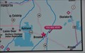 view gallery view galleryN43 km | Broadus Rest Area State Parks Map #2 in 'You Are Here' Maps You Are Here at the second of two similar maps showing Montana's state parks at the parking lot of the Broadus Rest Area on US Highway 212 south of the town of Broadus, Montana. posted by: brwhiz location: Montana date approved: 06/05/2013 last visited: never |
 view gallery view galleryN43 km | Broadus Rest Area State Parks Map #1 in 'You Are Here' Maps You Are Here at one of two similar maps showing Montana's state parks at the parking lot of the Broadus Rest Area on US Highway 212 south of the town of Broadus, Montana. posted by: brwhiz location: Montana date approved: 06/05/2013 last visited: never |
|