 view gallery view gallery SW4.8 km SW4.8 km
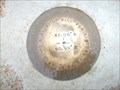
|   N45xW090 County Surveyers disk, WI N45xW090 County Surveyers disk, WI
in U.S. Benchmarks A special benchmark placed at N45.00 W90.00 posted by:  8Nuts MotherGoose 8Nuts MotherGoose location: Wisconsin date approved: 07/15/2010 last visited: 07/04/2023 |
 view gallery view gallerySW4.8 km |  Center of Northern Half of Western Hemisphere Center of Northern Half of Western Hemisphere
in Geographical Centers Half Way There posted by: 8Nuts MotherGoose location: Wisconsin date approved: 10/06/2007 last visited: 07/04/2023 |
 view gallery view gallerySW4.8 km |  N 45 W 90 - Rietbrock, WI N 45 W 90 - Rietbrock, WI
in Confluence Spots Halfway to the North Pole from the Equator. posted by: papermanone & catlover location: Wisconsin date approved: 11/23/2006 last visited: 07/04/2023 |
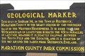
 view gallery view gallery W5.1 km W5.1 km
|  North 45 Parallel, West 90 Meridian - Marathon Co. WI, USA North 45 Parallel, West 90 Meridian - Marathon Co. WI, USA
in Great Lines of Earth A popular tourist stop in central Wisconsin posted by: cldisme location: Wisconsin date approved: 08/20/2009 last visited: 07/04/2023 |
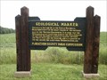
 view gallery view galleryW5.1 km |  Center of Northern Half of Western Hemisphere - N 45 W 90 Center of Northern Half of Western Hemisphere - N 45 W 90
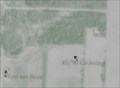
in Permanent Geographic Coordinates The center of the Northern Half of the Western Hemisphere is in the middle of a corn field in northern Wisconsin. Nearby is a sign commemorating the spot. posted by:  onfire4jesus onfire4jesus location: Wisconsin date approved: 12/23/2008 last visited: 07/04/2023 |
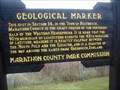
 view gallery view galleryW5.1 km |  Center of Northern Half of Western Hemisphere - Poniatowski, WI Center of Northern Half of Western Hemisphere - Poniatowski, WI
in 'You Are Here' Maps This marker commemorates the spot where the 90th meridian crosses the 45th parallel. On it is a map that shows the marker's location versus the actual spot of confluence. posted by: onfire4jesus location: Wisconsin date approved: 12/26/2008 last visited: 07/04/2023 |
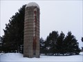
 view gallery view gallery E13 km E13 km
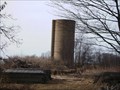
|  County Road "U" Silo - Stettin, WI County Road "U" Silo - Stettin, WI
in Solitary Silos This silo is on County Road "U" near the town of Stettin, WI posted by: REUAHNESIE location: Wisconsin date approved: 04/20/2011 last visited: never |
 view gallery view gallery NE13.8 km NE13.8 km
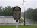
|  Pomeranian Settlement in Marathon County Pomeranian Settlement in Marathon County
in Wisconsin Historical Markers Pomeranian Settlement in Marathon County, Town of Berlin posted by: frankhj location: Wisconsin date approved: 04/08/2018 last visited: 08/04/2018 |
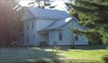 view gallery view galleryE20.4 km |  Single, Benjamin, House Single, Benjamin, House
in U.S. National Register of Historic Places The Benjamin Single House at 4708 Stettin Dr in Wausau, WI posted by: onfire4jesus location: Wisconsin date approved: 09/17/2007 last visited: 03/24/2010 |
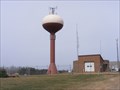
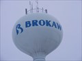 view gallery view galleryE20.9 km |  32nd Street Water Tower - Brokaw, WI 32nd Street Water Tower - Brokaw, WI
in Water Towers This is the Water Tower for Brokaw, WI a small village in Marathon County, Wisconsin. posted by: REUAHNESIE location: Wisconsin date approved: 01/11/2011 last visited: never |
 view gallery view galleryE20.9 km | 32nd Street Silo - Brokaw, WI in Solitary Silos This silo is in the village of Brokaw, WI a small comminity in Marathon County, Wisconsin. posted by: REUAHNESIE location: Wisconsin date approved: 01/12/2011 last visited: never |
 view gallery view galleryE21.2 km |  Brockmeyer Park - Wausau, WI Brockmeyer Park - Wausau, WI
in Public Playgrounds A 25 acre Community Park at 4200 Stettin Drive, Wausau, WI posted by: REUAHNESIE location: Wisconsin date approved: 03/18/2010 last visited: never |
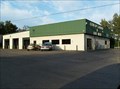 view gallery view galleryE21.4 km |  Cleaning Center - Wausau, WI Cleaning Center - Wausau, WI
in Coin Operated Self Service Car Washes The Cleaning Center offers not only coin operated car wash, but drycleaning and coin operated laundry as well. It is located at 3820 Stewart Ave in Wausau. posted by: onfire4jesus location: Wisconsin date approved: 09/25/2007 last visited: 03/24/2010 |
 view gallery view galleryE22 km | 28th Avenue Water Tower - Wausau, WI in Water Towers This is a Chocolate & Vanila Lollipop style water tower with Crown & Neckles in Wausau, WI posted by: REUAHNESIE location: Wisconsin date approved: 05/24/2010 last visited: 02/07/2013 |
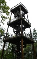 view gallery view gallery SE22.2 km SE22.2 km
|  Van Douser Tower - Rib Mountain State Park - Wausau, WI Van Douser Tower - Rib Mountain State Park - Wausau, WI
in Look-Out Towers This 60' observation tower has three decks and stands on the tallest hill in Wisconsin. It gives a tremendous view of the Wisconsin River Valley at Wausau and the surrounding countryside. posted by: onfire4jesus location: Wisconsin date approved: 09/28/2007 last visited: 06/01/2007 |
 view gallery view gallerySE22.2 km |  Van Douser Tower - Rib Mountain State Park - Wausau, WI Van Douser Tower - Rib Mountain State Park - Wausau, WI
in Scenic Overlooks This 60' observation tower has three decks and stands on the tallest hill in Wisconsin which is 1940' tall, giving a combined altitude of 2000', 860' above the river valley below. posted by: onfire4jesus location: Wisconsin date approved: 09/29/2007 last visited: 06/01/2007 |
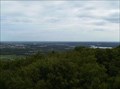
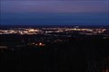 view gallery view gallerySE22.2 km |  Wausau City Skyline from Rib Mountain - Wausau, WI Wausau City Skyline from Rib Mountain - Wausau, WI
in Scenic at Night This 60' observation tower has three decks and stands on the tallest hill in Wisconsin. It gives a tremendous view of the Wisconsin River Valley at Wausau and the surrounding countryside. But for the best view, come at night! posted by: onfire4jesus location: Wisconsin date approved: 12/19/2008 last visited: 06/01/2010 |
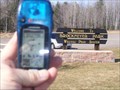
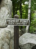 view gallery view gallerySE22.2 km |  Rib Mountain, WI (1940 ft.) Rib Mountain, WI (1940 ft.)
in Elevation Signs This elevation sign marks the summit of Rib Mountain. It is located in the Rib Mountain State Park near Wausau, WI posted by: onfire4jesus location: Wisconsin date approved: 09/28/2007 last visited: 06/01/2007 |
 view gallery view gallerySE22.2 km |  Rib Mountain, WI (1940 ft.) - Wausau, WI Rib Mountain, WI (1940 ft.) - Wausau, WI
in Mountain Summits This elevation sign marks the summit of Rib Mountain. It is located in the Rib Mountain State Park near Wausau, WI posted by: onfire4jesus location: Wisconsin date approved: 11/22/2007 last visited: 06/01/2010 |
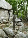
 view gallery view gallerySE22.2 km |  HIGHEST - known point in the state of Wisconsin - Rib Mountain HIGHEST - known point in the state of Wisconsin - Rib Mountain
in Superlatives Rib Mountain is the highest known point in the state of Wisconsin. posted by: onfire4jesus location: Wisconsin date approved: 09/29/2007 last visited: 04/16/2011 |
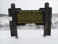
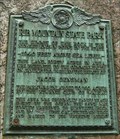
 view gallery view gallerySE22.4 km |  Rib Mountain Quartzite - Wausau, WI Rib Mountain Quartzite - Wausau, WI
in Places of Geologic Significance Rib Mountain is a Monadnock - a harder peak - composed of Quartzite. It is the highest rock hill in the state of Wisconsin. posted by: onfire4jesus location: Wisconsin date approved: 09/27/2007 last visited: 06/01/2010 |
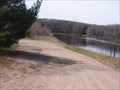 view gallery view galleryE22.4 km |  Brokaw boat ramp Brokaw boat ramp
in Boat Ramps The land is owned by Wausau paper Corp., but is open to the public for receational use. posted by: REUAHNESIE location: Wisconsin date approved: 04/21/2010 last visited: never |
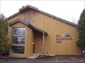 view gallery view gallerySE22.4 km |  Rib Mountain Inn - Rib Mountain, WI Rib Mountain Inn - Rib Mountain, WI
in Chalet, Cottage, and Cabin Style Lodging Chalet style Inn featuring fireside rooms, condos, townhouses and more. posted by: lenron location: Wisconsin date approved: 05/19/2011 last visited: never |
 view gallery view gallerySE22.4 km |  Rib Mountain Inn - Rib Mountain, WI Rib Mountain Inn - Rib Mountain, WI
in Dog Friendly Hotels Chalet Style lodging for you and your best friend in Rib Mountain WI. posted by: lenron location: Wisconsin date approved: 05/09/2011 last visited: never |
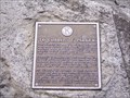 view gallery view gallerySE22.4 km |  Charles E. Parker - Rib Mountain, WI Charles E. Parker - Rib Mountain, WI
in Citizen Memorials Kiwanis dedication plaque to Charles E. Parker. posted by: lenron location: Wisconsin date approved: 04/28/2011 last visited: never |
|