 view gallery view gallery W6.4 km W6.4 km
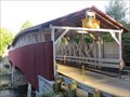
|   Pont-Couvert-de-Powerscourt - Powerscourt Covered Bridge - Powerscourt, Québec Pont-Couvert-de-Powerscourt - Powerscourt Covered Bridge - Powerscourt, Québec
in Canadian National Historic Sites Érigé en 1861, le Pont-Couvert-de-Powerscourt est l'un des plus anciens qui subsistent au Canada. Erected in 1861, the Powerscourt Covered Bridge is one of the oldest covered bridges in Canada. posted by:  Weathervane Weathervane location: Québec, Canada date approved: 06/03/2020 last visited: 03/30/2022 |
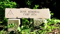 view gallery view galleryW6.4 km |  Dunn Memorial Scout Camp - Powerscourt, QC Dunn Memorial Scout Camp - Powerscourt, QC
in Boy Scout Camps The entrane to Dunn Memorial Scout Camp is located near the west entrance of the Powerscourt Covered Bridge. posted by:  denben denben location: Québec, Canada date approved: 02/17/2013 last visited: 07/20/2021 |
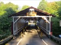 view gallery view galleryW6.4 km | ") Pont couvert de Powerscourt - Elgin, Québec Pont couvert de Powerscourt - Elgin, Québec
in Histoire du Quebec (Quebec Historical Markers) Le pont couvert de Powerscourt, aussi connu sous le nom de Pont Percy, est situé sur le chemin de la première concession, à Elgin (Hinchinbrooke), Québec. posted by: Weathervane location: Québec, Canada date approved: 09/25/2012 last visited: 07/20/2021 |
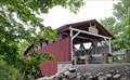 view gallery view galleryW6.4 km |  Pont de Powerscourt - Hinchinbrooke, Québec Pont de Powerscourt - Hinchinbrooke, Québec
in Covered Bridges un pont couvert situé à Hinchinbrooke, Québec - a covered bridge located in Hinchinbrooke, Quebec posted by: oiseau_ca location: Québec, Canada date approved: 04/01/2019 last visited: 07/20/2021 |
 view gallery view gallery S8.2 km S8.2 km
|  Chateaugay, New York Chateaugay, New York
in City and Town Halls The building is immediately west of the Stewart's gas bar. posted by: elyob location: New York date approved: 10/23/2019 last visited: never |
 view gallery view gallery NW11.9 km NW11.9 km
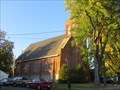
| Église Huntingdon United - Huntingdon, Québec in Histoire du Quebec (Quebec Historical Markers) Cette église fut construite en 1880 par les Méthodistes de Huntingdon. En 1926, l’église fut détruite par le feu. Seuls les murs restèrent. En 1927, l’église fut reconstruite mais sans la flèche du clocher original. posted by: Weathervane location: Québec, Canada date approved: 10/03/2014 last visited: 08/29/2022 |
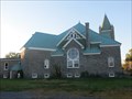 view gallery view galleryNW12.1 km | Église Saint-Andrew - Huntingdon, Québec in Histoire du Quebec (Quebec Historical Markers) L'église presbytérienne St. Andrew a été erigée entre 1904 et 1906. Le premier ministre fut le révérend William Montgomery Walker. Au fil des ans, quelques églises dans la région se fusionnèrent avec cette église. posted by: Weathervane location: Québec, Canada date approved: 10/03/2014 last visited: 08/29/2022 |
 view gallery view gallery E12.7 km E12.7 km
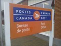
|  Bureau de Poste de Franklin Centre / Franklin Centre Post Office - QC - J0S 1E0 Bureau de Poste de Franklin Centre / Franklin Centre Post Office - QC - J0S 1E0
in Canada Post Offices Bureau de Poste de Franklin Centre / Franklin Centre Post Office posted by: Papichon location: Québec, Canada date approved: 09/22/2015 last visited: 07/18/2020 |
 view gallery view gallery NE15.1 km NE15.1 km
| Église de Saint-Malachie - Ormstown, Québec in Histoire du Quebec (Quebec Historical Markers) L'église de Sainte-Malachie, construite entre 1859 et 1861, est située sur la rue Bridge, à Ormstown. posted by: Weathervane location: Québec, Canada date approved: 10/03/2014 last visited: 03/29/2022 |
 view gallery view galleryNE15.4 km | Bureau de Poste d'Orsmtown / Orsmtown Post Office - Qc - J0S 1K0 in Canada Post Offices Bureau de Poste d'Orsmtown / Orsmtown Post Office posted by: Papichon location: Québec, Canada date approved: 06/15/2015 last visited: 03/29/2022 |
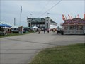 view gallery view galleryNE15.9 km |  Exhibition Ormstown Fair, Ormstown, QC, Canada Exhibition Ormstown Fair, Ormstown, QC, Canada
in Agricultural Fairgrounds Known far and wide simply as "Ormstown Fair" this non-profit organisation is operated by volunteers for the benefit of the community. posted by: stonefly626 location: Québec, Canada date approved: 05/26/2013 last visited: 03/29/2022 |
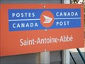 view gallery view galleryE16.3 km | Bureau de Poste de Saint-Antoine-Abbé / Saint-Antoine-Abbé Post Office - Qc - J0S 1N0 in Canada Post Offices Bureau de Poste de Saint-Antoine-Abbé / Saint-Antoine-Abbé Post Office posted by: Papichon location: Québec, Canada date approved: 08/09/2014 last visited: never |
 view gallery view gallery SW16.4 km SW16.4 km
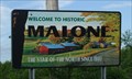
|  Malone, NY - The Star of The North Since 1802 Malone, NY - The Star of The North Since 1802
in Welcome Signs Malone, NY., County of Franklin
posted by: Sun Chasers location: New York date approved: 08/04/2008 last visited: 10/14/2011 |
 view gallery view gallerySW16.4 km |  Wind Plant, Finney Rd - Malone, NY Wind Plant, Finney Rd - Malone, NY
in Windmills One wind plant in a large wind farm. posted by: Sun Chasers location: New York date approved: 09/09/2008 last visited: 11/02/2014 |
 view gallery view gallery SE16.7 km SE16.7 km
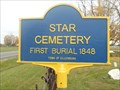
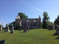
|  Star Cemetery - Ellenburg, NY Star Cemetery - Ellenburg, NY
in New York Historical Markers The Star Cemetery and its historical marker are located on Highway 190 (also known as Star Road) in Ellenburg, New York. posted by: Marine Biologist location: New York date approved: 10/13/2011 last visited: 02/07/2024 |
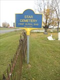 view gallery view gallerySE16.7 km |  Star Cemetery - Ellenburg, NY Star Cemetery - Ellenburg, NY
in Worldwide Cemeteries The Star Cemetery is located on Highway 190 (also known as Star Road) in Ellenburg, New York, USA. posted by: Marine Biologist location: New York date approved: 11/02/2011 last visited: 02/06/2024 |
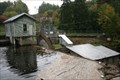
 view gallery view galleryS18 km |  Forge Dam aka Chateaugay Lake Dam Forge Dam aka Chateaugay Lake Dam
in Water Dams Small Dam at North end of Lower Chateaugay Lake posted by: fiftythree location: New York date approved: 10/07/2008 last visited: 11/02/2014 |
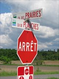 view gallery view galleryNW19.8 km |  Chemin de Planches - Saint-Anicet, QC Chemin de Planches - Saint-Anicet, QC
in Plank Roads Now an asphalted road, chemin de Planches (Plank Road) starts at Marina Port Lewis in Saint-Anicet and ends at chemin Ridge in Huntingdon, Québec. posted by: denben location: Québec, Canada date approved: 05/25/2012 last visited: 05/18/2024 |
 view gallery view galleryNE21.2 km |  Bataille de la Châteauguay - The Battle of the Châteauguay - Allans Corners, Québec Bataille de la Châteauguay - The Battle of the Châteauguay - Allans Corners, Québec
in War of 1812 Ici, le 26 octobre 1813, un corps canadiens arrêta le plus important projet d'invasion américaine de la guerre de 1812. Here, on 26 October 1813, a Canadian force halted the most ambitious enemy invasion of the War of 1812. posted by: Weathervane location: Québec, Canada date approved: 10/03/2014 last visited: 05/06/2017 |
 view gallery view galleryNE21.2 km | CNHS - Bataille de la Châteauguay - The Battle of the Châteauguay - Allans Corners, Québec in Canadian National Historic Sites Ici, le 26 octobre 1813, un corps canadiens arrêta le plus important projet d'invasion américaine de la guerre de 1812. Here, on 26 October 1813, a Canadian force halted the most ambitious enemy invasion of the War of 1812. posted by: Weathervane location: Québec, Canada date approved: 09/30/2014 last visited: 05/06/2017 |
 view gallery view gallerySW22.4 km | Macomb Dam in Water Dams Small dam with a powerplant on the Salmon River, NY posted by: fiftythree location: New York date approved: 09/28/2008 last visited: 11/02/2014 |
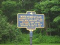 view gallery view galleryW22.4 km | Man Homestead - Constable, NY in New York Historical Markers House owned by the Man brothers posted by: vhasler location: New York date approved: 07/06/2010 last visited: 07/15/2012 |
 view gallery view gallerySW22.5 km | Morningside Cemetery - Malone, NY in New York Historical Markers Large urban cemetery in Malone NY, burial site of a VP and a music pioneer posted by: jiggs11 location: New York date approved: 09/04/2013 last visited: 11/02/2014 |
 view gallery view galleryNW22.9 km |  Godmanchester - St-Anicet, Quebec, Canada Godmanchester - St-Anicet, Quebec, Canada
in Ghost Towns Godmanchester Ghost Town is located in St-Anicet, Quebec, Canada. posted by: tatie location: Québec, Canada date approved: 06/26/2017 last visited: 05/18/2024 |
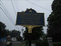
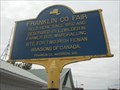 view gallery view gallerySW22.9 km |  Fenian Invasion Mobilization Site - Malone, New York, USA Fenian Invasion Mobilization Site - Malone, New York, USA
in Political Revolutions This historical marker on the Franklin County Fairgrounds in Malone, New York, USA, denotes the marshaling/mobilization site for two Irish Fenian invasions of Canada. posted by: Marine Biologist location: New York date approved: 01/16/2012 last visited: 08/22/2013 |
|