 view gallery view gallery NW13.8 km NW13.8 km
|   Biddle Southeast Webcam - Biddle, MT Biddle Southeast Webcam - Biddle, MT
in Web Cameras This is one of 73 (as of January 2017) Road Weather Information System cameras operated by the Montana Department of Transportation to aid motorists as they make their way across BIG SKY Country. posted by:  T0SHEA T0SHEA location: Montana date approved: 01/10/2017 last visited: never |
 view gallery view galleryNW13.8 km | Biddle Roadway Webcam - Biddle, MT in Web Cameras This is one of 73 (as of January 2017) Road Weather Information System cameras operated by the Montana Department of Transportation to aid motorists as they make their way across BIG SKY Country. posted by: T0SHEA location: Montana date approved: 01/10/2017 last visited: never |
 view gallery view galleryNW13.8 km | Biddle North Webcam - Biddle, MT in Web Cameras This is one of 73 (as of January 2017) Road Weather Information System cameras operated by the Montana Department of Transportation to aid motorists as they make their way across BIG SKY Country. posted by: T0SHEA location: Montana date approved: 01/10/2017 last visited: never |
 view gallery view galleryNW13.8 km | Biddle Northwest Webcam - Biddle, MT in Web Cameras This is one of 73 (as of January 2017) Road Weather Information System cameras operated by the Montana Department of Transportation to aid motorists as they make their way across BIG SKY Country. posted by: T0SHEA location: Montana date approved: 01/10/2017 last visited: never |
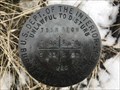 view gallery view gallery S27.8 km S27.8 km
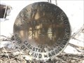
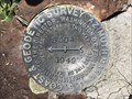
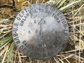
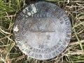
|  T55N R70W S30 S29 S32 S31 - Campbell County, Wyoming T55N R70W S30 S29 S32 S31 - Campbell County, Wyoming
in Public Land Survey Marks A USDI-Bureau of Land Management section corner marker in Thunder Basin National Grassland. posted by: Tom.dog location: Wyoming date approved: 02/25/2023 last visited: never |
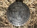
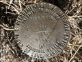
 view gallery view galleryS28.2 km | T55N R70W S30 S31 1/4 - Campbell County, Wyoming in Public Land Survey Marks A USDI-Bureau of Land Management quarter corner marker in Thunder Basin National Grassland. posted by: Tom.dog location: Wyoming date approved: 02/25/2023 last visited: never |
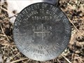
 view gallery view galleryS28.3 km | T55N R71W S25 S36 R70W S30 S31 - Campbell County, Wyoming in Public Land Survey Marks This USDI-Bureau of Land Management section corner marker in located along the western boundary of Thunder Basin National Grassland. posted by: Tom.dog location: Wyoming date approved: 02/25/2023 last visited: never |
 view gallery view galleryS28.6 km | T55N R71W S25 S36 1/4 - Campbell County, Wyoming in Public Land Survey Marks A USDI-Bureau of Land Management quarter corner marker in northern Campbell County. posted by: Tom.dog location: Wyoming date approved: 02/25/2023 last visited: never |
 view gallery view galleryS28.8 km | T55N R71W S26 S25 S36 S35 - Campbell County, Wyoming in Public Land Survey Marks This USDI-Bureau of Land Management section corner marker is located in northern Campbell County. posted by: Tom.dog location: Wyoming date approved: 02/25/2023 last visited: never |
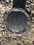
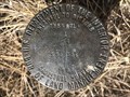
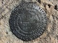
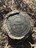 view gallery view galleryS29.1 km |  SODA NO 2 - Campbell County, Wyoming SODA NO 2 - Campbell County, Wyoming
in U.S. Benchmarks Reference mark 2 for triangulation station SODA (PV0541). posted by: Tom.dog location: Wyoming date approved: 01/08/2023 last visited: never |
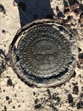
 view gallery view galleryS29.1 km | SODA (PV0541) - Campbell County, Wyoming in U.S. Benchmarks This triangulation station is located atop a hill in Thunder Basin National Grassland. posted by: Tom.dog location: Wyoming date approved: 01/08/2023 last visited: never |
 view gallery view galleryS29.1 km | SODA NO 1 - Campbell County, Wyoming in U.S. Benchmarks Reference mark 1 for triangulation station SODA (PV0541). posted by: Tom.dog location: Wyoming date approved: 01/08/2023 last visited: never |
 view gallery view galleryS29.5 km | T54N R70W S1 R69W S6 1/4 - Campbell County, Wyoming in Public Land Survey Marks This USDI-Bureau of Land Management quarter corner marker is located a short distance to the south of Heald Road in Thunder Basin National Grassland. posted by: Tom.dog location: Wyoming date approved: 01/20/2023 last visited: never |
 view gallery view galleryS29.5 km | T54N R69W S6 S5 1/4 RM - Campbell County, Wyoming in Public Land Survey Marks A quarter corner reference marker monumented by the USDI-Bureau of Land Management. posted by: Tom.dog location: Wyoming date approved: 05/15/2023 last visited: never |
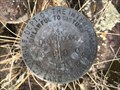
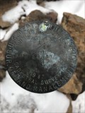
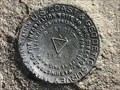
 view gallery view galleryS29.6 km | SODA Azimuth Mark - Campbell County, Wyoming in U.S. Benchmarks This is the elusive azimuth mark for triangulation station SODA (PV0541). posted by: Tom.dog location: Wyoming date approved: 07/02/2023 last visited: never |
 view gallery view galleryS29.6 km |  SODA Azimuth Mark - Campbell County, Wyoming SODA Azimuth Mark - Campbell County, Wyoming
in Azimuth Benchmarks Azimuth mark for triangulation station SODA (PV0541). posted by: Tom.dog location: Wyoming date approved: 07/02/2023 last visited: never |
 view gallery view galleryS29.6 km | T55N R71W S35 S36 1/4 - Campbell County, Wyoming in Public Land Survey Marks A USDI-Bureau of Land Management quarter corner marker in northern Campbell County. posted by: Tom.dog location: Wyoming date approved: 02/25/2023 last visited: never |
 view gallery view galleryS29.6 km | T54N R70W S4 S3 1/4 - Campbell County, Wyoming in Public Land Survey Marks A USDI-Bureau of Land Management quarter corner marker on Thunder Basin National Grassland. posted by: Tom.dog location: Wyoming date approved: 12/23/2022 last visited: never |
 view gallery view galleryS29.9 km | T55N R71W S36 R70W S31 T54N R71W S1 R70W S6 - Campbell County, Wyoming in Public Land Survey Marks This township corner is located in northern Campbell County. posted by: Tom.dog location: Wyoming date approved: 02/25/2023 last visited: never |
 view gallery view galleryS29.9 km | T54N R69W S6 S5 S 1/16 - Campbell County, Wyoming in Public Land Survey Marks This USDI-Bureau of Land Management sixteenth corner marker is located on Thunder Basin National Grassland. posted by: Tom.dog location: Wyoming date approved: 05/15/2023 last visited: never |
 view gallery view galleryS30.1 km | T55N R71W S36 T54N S1 1/4 - Campbell County, Wyoming in Public Land Survey Marks This USDI-Bureau of Land Management quarter corner marker is located in northern Campbell County. posted by: Tom.dog location: Wyoming date approved: 02/25/2023 last visited: never |
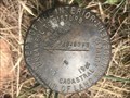
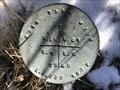
 view gallery view galleryS30.1 km | PRAIRIE NO 2 - Campbell County, Wyoming in U.S. Benchmarks Reference mark 2 for triangulation station PRAIRIE (PV0539). posted by: Tom.dog location: Wyoming date approved: 01/21/2023 last visited: never |
 view gallery view galleryS30.3 km | PRAIRIE (PV0539) - Campbell County, Wyoming in U.S. Benchmarks Triangulation station PRAIRIE is located on the northern highpoint of a forested ridge in Thunder Basin National Grassland. posted by: Tom.dog location: Wyoming date approved: 01/21/2023 last visited: never |
 view gallery view galleryS30.3 km | PRAIRIE NO 1 - Campbell County, Wyoming in U.S. Benchmarks Reference mark 1 for triangulation station PRAIRIE (PV0539). posted by: Tom.dog location: Wyoming date approved: 01/21/2023 last visited: never |
 view gallery view galleryS30.3 km | T54N R69W S6 S7 1/4 - Campbell County, Wyoming in Public Land Survey Marks USDI-Bureau of Land Management quarter corner marker on Thunder Basin National Grassland. posted by: Tom.dog location: Wyoming date approved: 05/15/2023 last visited: never |
|