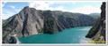
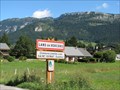
 view gallery view gallery S5.1 km S5.1 km
|   Lac de Monteynard-Avignonet - Treffort, Rhône Alpes Auvergne Lac de Monteynard-Avignonet - Treffort, Rhône Alpes Auvergne
in Wikipedia Entries Le lac de Monteynard-Avignonet est une retenue d'eau artificielle sur le Drac, dans le département de l'Isère, alimentant une centrale hydro-électrique EDF. posted by:  YvesProvence YvesProvence location: Auvergne-Rhône-Alpes, France date approved: 07/04/2017 last visited: 10/30/2017 |
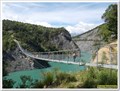 view gallery view galleryS9.3 km |  La passerelle himalayenne sur l'Ebron - Treffort, Auvergne-Rhône-Alpes, France La passerelle himalayenne sur l'Ebron - Treffort, Auvergne-Rhône-Alpes, France
in Pedestrian Suspension Bridges La passerelle himalayenne sur l'Ebron posted by: YvesProvence location: Auvergne-Rhône-Alpes, France date approved: 07/04/2017 last visited: never |
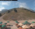 view gallery view gallery NW12.4 km NW12.4 km
|  Villard-de-Lans : au resto Villard-de-Lans : au resto
in Web Cameras Situé à 1720 m et accessible aux piétons et skieurs par la télécabine Cote 2000 : Restaurant self-service, bar , vue panoramique. posted by:  fk_isere fk_isere location: France date approved: 08/21/2009 last visited: 01/17/2022 |
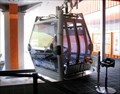 view gallery view galleryNW14.2 km |  Villard de Lans Gondola Lift - Isère, France Villard de Lans Gondola Lift - Isère, France
in Aerial Lifts This gondola lift is located at the Station Cote 2000 in Villard de Lans, Isère, Rhône-Alpes. posted by: denben location: Auvergne-Rhône-Alpes, France date approved: 01/21/2014 last visited: 01/17/2022 |
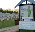
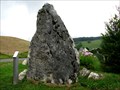 view gallery view galleryNW15.1 km |  Menhir du Vercors - Corrençon-en-Vercors, France Menhir du Vercors - Corrençon-en-Vercors, France
in Rock and Mineral Displays This rock is located at the entrance of the village to welcome and inform visitors that will use Corrençon-en-Vercors numerous hiking trails. posted by: denben location: Auvergne-Rhône-Alpes, France date approved: 01/05/2014 last visited: never |
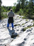 view gallery view galleryNW15.3 km |  Lapiaz des Hauts Plateaux du Vercors - Corrençon-en-Vercors, France Lapiaz des Hauts Plateaux du Vercors - Corrençon-en-Vercors, France
in Places of Geologic Significance The lapiaz (Limestone Pavement) along the GR 91, a 40 km trail between Corrençon-en-Vercors and the Col de Rousset, crossing the Hauts Plateaux du Vercors (French Prealps). posted by: denben location: Auvergne-Rhône-Alpes, France date approved: 02/12/2014 last visited: never |
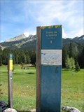 view gallery view galleryNW15.3 km |  Le Champ de Bataille - Corrençon-en-Vercors, France Le Champ de Bataille - Corrençon-en-Vercors, France
in Battlefields The battlefield markers are located along Corrençon golf course on the GR 91, a 40 km trail between Corrençon-en-Vercors and the Col de Rousset. posted by: denben location: Auvergne-Rhône-Alpes, France date approved: 01/09/2014 last visited: never |
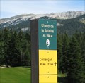 view gallery view galleryNW15.3 km |  Champ de Bataille - 3930 feet - Corrençon-en-Vercors, France Champ de Bataille - 3930 feet - Corrençon-en-Vercors, France
in Elevation Signs The battlefield markers are located along Corrençon golf course on the GR 91, a 40 km trail between Corrençon-en-Vercors and the Col de Rousset. posted by: denben location: Auvergne-Rhône-Alpes, France date approved: 01/09/2014 last visited: never |
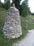 view gallery view galleryNW15.3 km |  Trailhead Cairn - Corrençon-en-Vercors, Rhône-Alpes, France Trailhead Cairn - Corrençon-en-Vercors, Rhône-Alpes, France
in Cairns This cairn is located in front of the Corrençon-en-Vercors golf course buildings near the parking des Hauts-Plateaux. posted by: denben location: Auvergne-Rhône-Alpes, France date approved: 01/07/2014 last visited: 07/23/2014 |
 view gallery view galleryNW15.4 km |  Golf de Corrençon - Corrençon-en-Vercors, France Golf de Corrençon - Corrençon-en-Vercors, France
in Public and Private Golf Courses Corrençon Golf Course is a 18-hole par 71 mountain golf course located in the spectacular scenery of the Vercors massif. posted by: denben location: Auvergne-Rhône-Alpes, France date approved: 02/05/2014 last visited: 07/23/2014 |
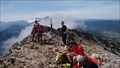 view gallery view gallery N15.9 km N15.9 km
|  Pic Saint Michel Summit, Vercors, France Pic Saint Michel Summit, Vercors, France
in Mountain Summits Pic Saint-Michel at 1,966 m, is one of the principle summits in the Vercors area of France. posted by: arby101ca location: Auvergne-Rhône-Alpes, France date approved: 08/02/2015 last visited: 07/28/2022 |
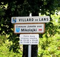 view gallery view galleryNW16.6 km |  Villard-de-Lans, France - Mikolajki, Poland Villard-de-Lans, France - Mikolajki, Poland
in Sister City Monuments This Sister City sign is located at the south entrance to the Commune de Villard-de-Lans on Av. des Bains (D215). posted by: denben location: Auvergne-Rhône-Alpes, France date approved: 01/20/2014 last visited: 01/17/2022 |
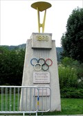 view gallery view galleryNW16.9 km |  Monument to the 1968 Winter Olympics - Villard-de-Lans, France Monument to the 1968 Winter Olympics - Villard-de-Lans, France
in Olympic Memorabilia At the 1968 Winter Olympics held in neighbouring Grenoble, Villard-de-Lans played host to the luge events. posted by: denben location: Auvergne-Rhône-Alpes, France date approved: 10/09/2013 last visited: 01/17/2022 |
 view gallery view gallery SE17.1 km SE17.1 km
|  Eglise de La Salle en Beaumont - France Eglise de La Salle en Beaumont - France
in Roman Catholic Churches Notre-Dame-de-l'Assomption (construite en 1998 en remplacement de l'ancienne église, détruite par un glissement de terrain).
Notre-Dame-de-l'Assomption (built in 1998 to replace the old church, destroyed by a landslide). posted by: Alfouine location: Auvergne-Rhône-Alpes, France date approved: 02/09/2020 last visited: never |
 view gallery view gallerySE17.1 km |  Eglise de La Salle en Beaumont - France Eglise de La Salle en Beaumont - France
in Signs of Zodiac Notre-Dame-de-l'Assomption (construite en 1998 en remplacement de l'ancienne église, détruite par un glissement de terrain).
Notre-Dame-de-l'Assomption (built in 1998 to replace the old church, destroyed by a landslide). posted by: Alfouine location: Auvergne-Rhône-Alpes, France date approved: 02/08/2020 last visited: never |
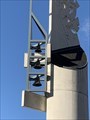
 view gallery view gallerySE17.1 km |  Eglise de La Salle en Beaumont - France Eglise de La Salle en Beaumont - France
in Bell Towers Notre-Dame-de-l'Assomption (construite en 1998 en remplacement de l'ancienne église, détruite par un glissement de terrain).
Notre-Dame-de-l'Assomption (built in 1998 to replace the old church, destroyed by a landslide). posted by: Alfouine location: Auvergne-Rhône-Alpes, France date approved: 02/08/2020 last visited: never |
 view gallery view gallerySE17.1 km |  Eglise de La Salle en Beaumont - France Eglise de La Salle en Beaumont - France
in Unique Steeples Notre-Dame-de-l'Assomption (construite en 1998 en remplacement de l'ancienne église, détruite par un glissement de terrain).
Notre-Dame-de-l'Assomption (built in 1998 to replace the old church, destroyed by a landslide). posted by: Alfouine location: Auvergne-Rhône-Alpes, France date approved: 02/08/2020 last visited: never |
 view gallery view galleryNW21.1 km | Lans-en-Vercors, France / Saint-Donat, Québec, Canada in Sister City Monuments This Sister City sign is located at the south entrance to the Commune de Lans-en-Vercors on the Route de Villard (D531). posted by: denben location: Auvergne-Rhône-Alpes, France date approved: 01/02/2014 last visited: 07/27/2018 |
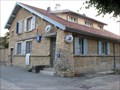 view gallery view gallery W21.2 km W21.2 km
|  La Poste - La Chapelle-en-Vercors, France La Poste - La Chapelle-en-Vercors, France
in European Post Offices The post office is located beside the French National Historic Site, "La cour des fusillés" in La Chapelle-en-Vercors. posted by: denben location: Auvergne-Rhône-Alpes, France date approved: 01/13/2014 last visited: 07/01/2018 |
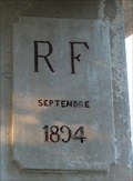 view gallery view galleryW21.4 km |  Fontaine aux Ours - 1894 - La Chapelle-en-Vercors, France Fontaine aux Ours - 1894 - La Chapelle-en-Vercors, France
in Dated Architectural Structures Multifarious The fontaine aux ours (two bears fountain) is located avenue de Provence in the heart of La Chapelle-en-Vercors, France. posted by: denben location: Auvergne-Rhône-Alpes, France date approved: 09/06/2014 last visited: 07/01/2018 |
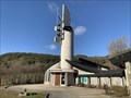
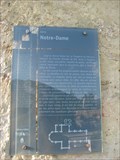 view gallery view galleryW21.4 km | ") Église Notre-Dame - La Chapelle-en-Vercors, France Église Notre-Dame - La Chapelle-en-Vercors, France
in Histoires de France (French historical markers) La plaque historique est installée près de la porte du clocher, sur la façade de l'église Notre-Dame-de-l'Assomption à La Chapelle-en-Vercors. posted by: denben location: Auvergne-Rhône-Alpes, France date approved: 01/13/2014 last visited: 07/01/2018 |
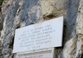
 view gallery view galleryW21.6 km | Route des Grands Goulets - Les Barraques-en-Vercors, France in Histoires de France (French historical markers) A commemorative plaque to the old Road des Grands Goulets is located on a rock wall near the closed entrance to the road in Les Barraques-en-Vercors. posted by: denben location: Auvergne-Rhône-Alpes, France date approved: 07/09/2020 last visited: 07/01/2018 |
 view gallery view galleryW21.6 km |  World War II Memorial - Les Barraques-en-Vercors, France World War II Memorial - Les Barraques-en-Vercors, France
in World War II Memorials / Monuments This World War II plaque is located on a rock wall near the entrance to the old Road des Grands Goulets in Les Barraques-en-Vercors. posted by: denben location: Auvergne-Rhône-Alpes, France date approved: 01/14/2014 last visited: 07/01/2018 |
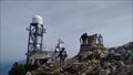 view gallery view galleryN21.7 km | Le Moucherotte Summit in Mountain Summits Le Moucherotte, 1,901 m, most northerly summit of the Vercors massif. Although it is the lowest of the principle summits of the Vercors, it is perhaps the best known as it dominates the city of Grenoble. posted by: arby101ca location: Auvergne-Rhône-Alpes, France date approved: 08/02/2015 last visited: 07/28/2022 |
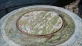 view gallery view galleryN21.7 km |  Moucherotte Summit Orientation Table Moucherotte Summit Orientation Table
in Orientation Tables Above Grenoble France, the Moucherotte summit is the north end of the Vercors plateau western crest. At the summit is an orientation table identifying the surrounding peaks in the Alps and Vercors area. posted by: arby101ca location: Auvergne-Rhône-Alpes, France date approved: 08/02/2015 last visited: never |
|