 view gallery view gallery S0.6 km S0.6 km
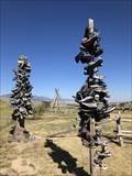
|   Twin Shoe Trees - Lima, Montana Twin Shoe Trees - Lima, Montana
in Shoe Trees Twin shoe trees at a hotel/ RV park off of the interstate. posted by:  flyingmoose flyingmoose location: Montana date approved: 08/25/2020 last visited: never |
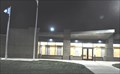
 view gallery view galleryS0.6 km |  Lima, Montana Lima, Montana
in Small Town, Big Name A small town along the Interstate in southern Montana. posted by: flyingmoose location: Montana date approved: 08/26/2020 last visited: never |
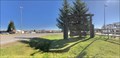
 view gallery view galleryS0.8 km |  Interstate 15 Lima Rest Area Interstate 15 Lima Rest Area
in Highway Rest Areas The Lima Rest Area is on the east side of Interstate Highway 15 just north of the Idaho/Montana border at Exit 15. posted by: brwhiz location: Montana date approved: 10/16/2012 last visited: never |
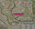 view gallery view galleryS0.8 km |  Interstate 15 Lima Rest Area Interstate 15 Lima Rest Area
in 'You Are Here' Maps You Are Here at the Montana Department of Transportation Lima Rest Area on the east side of Interstate Highway 15 just north of the Idaho/Montana border. posted by: brwhiz location: Montana date approved: 10/16/2012 last visited: never |
 view gallery view gallery SE2.4 km SE2.4 km
|  L for Lima, Montana L for Lima, Montana
in Letters on Hills The "L" for Lima is easily seen from Hwy 15 that passes the small town. posted by: Queens Blessing location: Montana date approved: 10/24/2010 last visited: 09/02/2013 |
 view gallery view gallery E23.7 km E23.7 km
|  Monida Pass Interchange Camera - Lima, MT Monida Pass Interchange Camera - Lima, MT
in Web Cameras This is one of 73 (as of January 2017) Road Weather Information System camera sites operated by the Montana Department of Transportation to aid motorists as they make their way across BIG SKY Country. posted by: T0SHEA location: Montana date approved: 02/02/2017 last visited: never |
 view gallery view galleryE23.8 km | Monida Pass West Camera - Lima, MT in Web Cameras This is one of 73 (as of January 2017) Road Weather Information System camera sites operated by the Montana Department of Transportation to aid motorists as they make their way across BIG SKY Country. posted by: T0SHEA location: Montana date approved: 02/02/2017 last visited: never |
 view gallery view galleryE23.8 km | Monida Pass Roadway Camera - Lima, MT in Web Cameras This is one of 73 (as of January 2017) Road Weather Information System camera sites operated by the Montana Department of Transportation to aid motorists as they make their way across BIG SKY Country. posted by: T0SHEA location: Montana date approved: 02/02/2017 last visited: never |
 view gallery view galleryE23.8 km | Monida Pass Southeast Camera - Lima, MT in Web Cameras This is one of 73 (as of January 2017) Road Weather Information System camera sites operated by the Montana Department of Transportation to aid motorists as they make their way across BIG SKY Country. posted by: T0SHEA location: Montana date approved: 02/02/2017 last visited: never |
 view gallery view gallerySE25.4 km |  Benchmark disk 6796.0 - Clark County, Idaho, USA Benchmark disk 6796.0 - Clark County, Idaho, USA
in U.S. Benchmarks An older benchmark set into the concrete of a truss bridge crossing old Highway 91, near the Montana border in Clark County, Idaho. posted by:  The Pirate King The Pirate King location: Idaho date approved: 07/20/2012 last visited: 07/13/2012 |
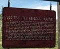 view gallery view gallery NW28.8 km NW28.8 km
|  Old Trail to the Gold Diggins, Lima, Montana Old Trail to the Gold Diggins, Lima, Montana
in Montana Historical Markers I have read a LOT of signs placed by State highway departments in my travels to all 50 state, but this one is uniquely sarcastic. posted by: Queens Blessing location: Montana date approved: 10/25/2010 last visited: 07/12/2006 |
 view gallery view gallerySE40.2 km |  #222 - Beaver Canyon #222 - Beaver Canyon
in Idaho Historical Markers History sign the Beaver Canyon Stage Station. posted by: Volcanoguy location: Idaho date approved: 07/25/2012 last visited: 10/06/2010 |
 view gallery view gallerySE42.2 km | PZ0146 - USCGS IDA 15-144 1959 - Idaho in U.S. Benchmarks U.S. Coast & Geodetic Survey azimuth mark 15-144, Idaho. posted by: Volcanoguy location: Idaho date approved: 06/03/2012 last visited: 10/06/2010 |
 view gallery view gallerySE44.6 km |  UP 25075 - Spencer, Idaho UP 25075 - Spencer, Idaho
in Train Cabooses UP 25075 Caboose in Spencer, Idaho. posted by: Volcanoguy location: Idaho date approved: 01/10/2011 last visited: 10/06/2010 |
 view gallery view gallerySE44.9 km |  Spencer, Idaho Spencer, Idaho
in Elevation Signs Elevation sign at Spencer, Idaho. posted by: Volcanoguy location: Idaho date approved: 01/08/2011 last visited: 10/06/2010 |
 view gallery view gallerySE44.9 km |  Bell in Spencer, Idaho Bell in Spencer, Idaho
in Bells Bell on small platform in Spencer, Idaho. posted by: Volcanoguy location: Idaho date approved: 01/08/2011 last visited: 10/06/2010 |
 view gallery view gallerySE44.9 km |  Spencer Rock House - Spencer, Idaho Spencer Rock House - Spencer, Idaho
in U.S. National Register of Historic Places The historic Spencer Rock House in Spencer, Idaho. posted by: Volcanoguy location: Idaho date approved: 01/09/2011 last visited: 10/06/2010 |
 view gallery view galleryNW44.9 km | Corps of Discovery II – Camp Fortunate, Montana in U.S. Benchmarks Corps of Discovery II – Camp Fortunate, MT, is a four-inch Lewis and Clark commemorative disk located in the Camp Fortunate Recreation Area at Clark Canyon Reservoir, MT. posted by: seventhings location: Montana date approved: 09/11/2006 last visited: never |
 view gallery view gallerySE45.1 km | Spencer in Idaho Historical Markers History sign in Spencer, Idaho. posted by: Volcanoguy location: Idaho date approved: 07/25/2012 last visited: 10/06/2010 |
 view gallery view gallerySE45.1 km |  Spencer - Lost Gold Trails Loop - Idaho Spencer - Lost Gold Trails Loop - Idaho
in National Scenic Byways Three information signs for Fort Henry Historic & Lost Gold Trails Byways. posted by: Volcanoguy location: Idaho date approved: 06/03/2012 last visited: 10/06/2010 |
 view gallery view gallery SW51.7 km SW51.7 km
| Sacajawea Historic Byway near Charcoal Kilns - Idaho in National Scenic Byways Information sign for Sacajawea Historic Byway. posted by: Volcanoguy location: Idaho date approved: 07/10/2012 last visited: 08/15/2012 |
 view gallery view gallerySW51.7 km | #296 - Charcoal Kilns in Idaho Historical Markers History sign along Idaho Hwy. 28. posted by: Volcanoguy location: Idaho date approved: 07/25/2012 last visited: 08/15/2012 |
 view gallery view gallerySW51.7 km | #429 - Cote’s Defile in Idaho Historical Markers History sign along Idaho Hwy. 28. posted by: Volcanoguy location: Idaho date approved: 07/25/2012 last visited: 08/15/2012 |
 view gallery view gallerySW51.7 km | PZ0743 - USCGS MAMMOTH - 1950 - Idaho in U.S. Benchmarks U.S. Coast & Geodetic Survey triangulation station MAMMOTH. posted by: Volcanoguy location: Idaho date approved: 07/10/2012 last visited: 10/07/2010 |
 view gallery view gallerySW51.7 km | PZ0743 - USCGS MAMMOTH NO 2 - 1950 - Idaho in U.S. Benchmarks U.S. Coast & Geodetic Survey reference mark MAMMOTH NO 2. posted by: Volcanoguy location: Idaho date approved: 07/10/2012 last visited: 10/07/2010 |
|