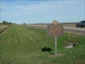
 view gallery view gallery SW6 km SW6 km
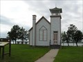
|   Oahe Chapel Oahe Chapel
in U.S. National Register of Historic Places The Oahe Chapel dates back to 1877. posted by:  MNSearchers MNSearchers location: South Dakota date approved: 05/28/2007 last visited: 02/15/2011 |
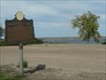
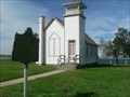 view gallery view gallerySW6 km |  Oahe Mission School and Chapel ~ 1877 Oahe Mission School and Chapel ~ 1877
in South Dakota Historical Markers Structure built in 1877 to serve as Chapel and School for a huge region. posted by: plainsdrifter358 location: South Dakota date approved: 10/07/2006 last visited: 02/15/2011 |
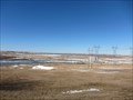
 view gallery view gallery S7.1 km S7.1 km
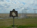
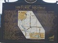
| The Missouri River Historic Highway ~ Oahe Overlook in South Dakota Historical Markers Historic Sites and Activities along the Missouri River from 1804 to the present day. posted by: plainsdrifter358 location: South Dakota date approved: 06/28/2006 last visited: 09/06/2019 |
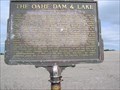 view gallery view galleryS7.1 km | The Oahe Dam and Lake in South Dakota Historical Markers This huge structure and its lake, which are 200 miles long, will cover a multitude of Historic Sites. posted by: MNSearchers location: South Dakota date approved: 05/29/2007 last visited: 09/06/2019 |
 view gallery view gallerySW7.2 km |  Oahe Dam - Missouri River - Pierre, SD Oahe Dam - Missouri River - Pierre, SD
in Water Dams Oahe Dam in South Dakota. posted by: dbrockhouse location: South Dakota date approved: 03/24/2011 last visited: 09/06/2019 |
 view gallery view galleryS7.9 km | Sioux Indian Mosaic in South Dakota Historical Markers An Arikara was honored by his enemy, the Sioux, with cairn (mound of stones) marked with the Sioux Tribal sign of the turtle. posted by: plainsdrifter358 location: South Dakota date approved: 10/07/2006 last visited: 09/06/2019 |
 view gallery view gallerySW8.9 km | Centre of Missouri Valley History & Historic Highway in South Dakota Historical Markers Half way between the mouth to the source of the Missouri River, was the center of the fur trade for half a century. posted by: plainsdrifter358 location: South Dakota date approved: 10/08/2006 last visited: 05/27/2007 |
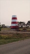 view gallery view gallery NW11.7 km NW11.7 km
|  Codger's Cove Campground Lighthouse Codger's Cove Campground Lighthouse
in Landlocked Lighthouses Great reproduction of a coastal lighthouse
at the entrance into a housing development and campground. posted by: dbrockhouse location: South Dakota date approved: 09/05/2017 last visited: never |
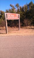 view gallery view galleryNW11.7 km |  Cow Creek Campground, Grey Goose, SD Cow Creek Campground, Grey Goose, SD
in Campgrounds Cow Creek Campground located on Cow Creek area on the eastern shore of the Missouri River fifteen miles north of Pierre,SD posted by: dbrockhouse location: South Dakota date approved: 11/23/2011 last visited: never |
 view gallery view galleryS12.1 km | Scotty Philip Graveyard in Ft. Pierre in South Dakota Historical Markers James 'Scotty' Philip, well known figure in South Dakota history who is perhaps best remembered for his successful effort in saving the buffalo from disappearance in this country. posted by: plainsdrifter358 location: South Dakota date approved: 10/09/2006 last visited: 05/28/2007 |
 view gallery view galleryS13.7 km | The Missouri River was Historic Highway ~ S to Ft. Thompson in South Dakota Historical Markers South to Fort Thompson and Chamberlain.
posted by: MNSearchers location: South Dakota date approved: 05/30/2007 last visited: 07/03/2012 |
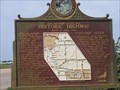 view gallery view galleryS13.7 km | The Missouri River was Historic Highway ~ North to Oahe Dam in South Dakota Historical Markers North to Oahe Dam. posted by: MNSearchers location: South Dakota date approved: 05/31/2007 last visited: 10/08/2009 |
 view gallery view galleryS14.3 km |  U-Haul TR: Mitchell, SD U-Haul TR: Mitchell, SD
in U-Haul SuperGraphics Welcome to Mitchell, South Dakota, "Home of the World's Only Corn Palace". posted by:  Team Cloverfrogs Team Cloverfrogs location: South Dakota date approved: 08/01/2009 last visited: 11/02/2022 |
 view gallery view galleryS14.8 km |  McDonald's, Pierre, South Dakota McDonald's, Pierre, South Dakota
in McDonald's Restaurants This McDonalds is located near the convention center and the Missouri River. posted by: NGComets location: South Dakota date approved: 04/20/2011 last visited: 07/07/2021 |
 view gallery view galleryS15 km | U-Haul #96: South Dakota in U-Haul SuperGraphics Part of Central United States, South Dakota is a fascinating area that features interesting geological and historical opportunities. Pierre, the capital city is well worth a visit! posted by: The Blue Quasar location: South Dakota date approved: 02/14/2009 last visited: 01/20/2023 |
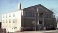 view gallery view galleryS15 km |  Pierre, South Dakota, Masonic Temple Pierre, South Dakota, Masonic Temple
in Masonic Temples Pierre Lodge #27, A.F. & A.M., meets the 2nd Monday of the month at 7:00 p.m. The Lodge is dark during July and August. posted by: windtimber location: South Dakota date approved: 06/28/2007 last visited: 02/15/2011 |
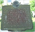 view gallery view galleryS15.1 km |  FIRST - And Only Hanging,Hughes County,SD FIRST - And Only Hanging,Hughes County,SD
in First of its Kind First and only Hanging,Pierre,South Dakota posted by: GEO*Trailblazer 1 location: South Dakota date approved: 12/12/2006 last visited: 12/12/2006 |
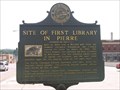 view gallery view galleryS15.1 km | Site of First Library in Pierre in South Dakota Historical Markers Built in 1904 with a 12,500$ gift from the Andrew Carnegie Foundation, the Library opened its doors on march 10, 1905. posted by: MNSearchers location: South Dakota date approved: 05/30/2007 last visited: 06/10/2012 |
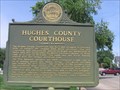 view gallery view galleryS15.1 km | Hughes County Courthouse in South Dakota Historical Markers In the moraine which runs along the bank of the Missouri in Hughes
County, stone cutters find a good source of many kinds of fine granite
useful for tombstones and building materials. The stones of the County
Courthouse in Pierre were cut from the boulder found in this great
moraine. posted by: MNSearchers location: South Dakota date approved: 05/30/2007 last visited: 06/10/2012 |
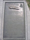 view gallery view galleryS15.1 km | John Charles Waldron in South Dakota Historical Markers (24 August 1900 – 4 June 1942) was a United States Navy aviator who led a squadron of torpedo bombers in World War II. posted by: MNSearchers location: South Dakota date approved: 05/29/2007 last visited: 05/06/2019 |
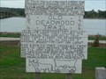 view gallery view galleryS15.1 km | Old Deadwood Trail 1876 ~ 1906 in South Dakota Historical Markers Freight on Steamboats were put on oxen-drawn wagons and delivered 200 miles west and 30 days later in Deadwood to supply the great Black Hills Gold Rush. posted by: plainsdrifter358 location: South Dakota date approved: 10/09/2006 last visited: 10/13/2012 |
 view gallery view galleryS15.1 km | History Unfolds in South Dakota Historical Markers History Unfolds locates the Ft. Pierre to Deadwood Trail, Ft. Pierre Choteau, capital of the N.W. (1831-1855), Ft. Galpin (1857), New Ft. Pierre (1859-1866), Aricara Villages & Fortress (1400-1790), Ft. LaFrombois II (1862-1865), and Ft. Primeau (1862). posted by: plainsdrifter358 location: South Dakota date approved: 06/27/2006 last visited: 05/27/2007 |
 view gallery view galleryS15.3 km |  World") South Dakota State Capitol - Pierre, SD South Dakota State Capitol - Pierre, SD
in Domes of the (Under) World Inside the neoclassical dome of the South Dakota State Capitol Building, dedicated in 1910. posted by: hykesj location: South Dakota date approved: 12/29/2023 last visited: never |
 view gallery view galleryS15.3 km |  South Dakota State Capitol - Pierre, SD South Dakota State Capitol - Pierre, SD
in Satellite Imagery Oddities The state capitol for the State of South Dakota is at 500 E Capitol Avenue, Pierre, SD. posted by: QuarrellaDeVil location: South Dakota date approved: 06/11/2020 last visited: 11/17/2022 |
 view gallery view galleryS15.3 km |  South Dakota State Capitol, Pierre, So. Dak. South Dakota State Capitol, Pierre, So. Dak.
in Capitol Buildings The South Dakota Capitol is located in downtown Pierre and Pierre is located on the Missouri River. posted by: two bison location: South Dakota date approved: 09/24/2006 last visited: 11/17/2022 |
|