 view gallery view gallery NW6 km NW6 km
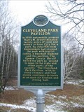
|   Cleveland Park Pavilion Cleveland Park Pavilion
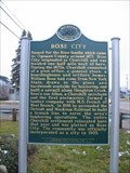
in Michigan Historical Markers Cleveland Park Pavilion is located in Rose City, Mi. posted by:  Jagman714 Jagman714 location: Michigan date approved: 11/18/2006 last visited: 02/13/2022 |
 view gallery view gallery NE6.1 km NE6.1 km
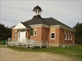
| Rose Township District No. 5 School in Michigan Historical Markers Located on the east side of Cherry Street, between Penn and Malone Streets. Streetside parking is available. posted by:  S5280ft S5280ft location: Michigan date approved: 05/28/2007 last visited: 07/07/2014 |
 view gallery view galleryNE6.1 km |  Geodesic Storage Shed - Lupton, MI Geodesic Storage Shed - Lupton, MI
in Odd-Shaped Buildings Located in a private residence on Ash Street in Lupton. Best viewed from the old Rose Township District No. 5 Schoolhouse on Cherry Street, between Penn and Malone Streets. posted by: S5280ft location: Michigan date approved: 05/29/2007 last visited: never |
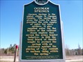
 view gallery view galleryNW6.1 km | Rose City / The Big Fire in Michigan Historical Markers Rose City / The Big Fire this double marker is on M33 in Rose City,Mi. posted by: Jagman714 location: Michigan date approved: 11/18/2006 last visited: 02/13/2022 |
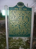 view gallery view galleryNW6.1 km |  Rose City, MI.- The Big Fire Rose City, MI.- The Big Fire
in Famous Fires Rose City is located in Northern Michigan. posted by: Jagman714 location: Michigan date approved: 06/28/2007 last visited: 07/06/2008 |
 view gallery view gallery SW18.3 km SW18.3 km
| Frank Sebastian Smith House in Michigan Historical Markers This should be an informational (small) marker, but it is not visible. The house is located on the southwest corner of Houghton Avenue and Livingston Street. Street parking is available on Livingston Street. posted by: S5280ft location: Michigan date approved: 05/28/2007 last visited: 04/27/2015 |
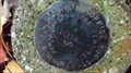
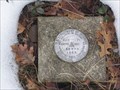 view gallery view galleryNE19.2 km |  USDI - 58 WPR 1965 USDI - 58 WPR 1965
in U.S. Benchmarks U.S. Department of Interior triangulation disc set in top of concrete monument posted by: Tom n Chris location: Michigan date approved: 01/16/2006 last visited: 09/15/2011 |
 view gallery view gallerySW20 km |  Subway - Cook Rd. - West Branch, MI Subway - Cook Rd. - West Branch, MI
in Subway Restaurants Subway restaurant located just north of I-75 in West Branch, Michigan. posted by: bobfrapples8 location: Michigan date approved: 05/10/2023 last visited: never |
 view gallery view gallerySW20 km |  Giant Lumber Jack, West Branch, MI Giant Lumber Jack, West Branch, MI
in Ginormous Everyday Objects This giant sits out by the road in front of the Lumber Jack Restaurant in West Branch, MI posted by: jub8 location: Michigan date approved: 08/18/2006 last visited: 07/06/2013 |
 view gallery view gallerySW20.3 km | Ogemaw Springs in Michigan Historical Markers Next to the spring, a little parking area for this. posted by: Historic Markers location: Michigan date approved: 04/28/2015 last visited: 09/26/2021 |
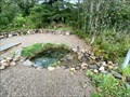 view gallery view gallerySW20.3 km |  Ogemaw Springs - West Branch, MI Ogemaw Springs - West Branch, MI
in Natural Springs A natural spring that fed the community and the nearby train line. posted by: bobfrapples8 location: Michigan date approved: 12/30/2021 last visited: never |
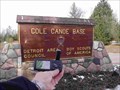 view gallery view gallery S22.9 km S22.9 km
|  Cole Canoe Base Cole Canoe Base
in Boy Scout Camps Michigan's Premier High Adventure Scout Camp. posted by: Screechowl location: Michigan date approved: 10/19/2005 last visited: never |
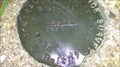
 view gallery view galleryNE23.7 km |  Michaud Road Survey Marker(Federal Land Office Survey) Michaud Road Survey Marker(Federal Land Office Survey)
in Public Land Survey Marks Federal Land Office Survey Marker.
Notation is "Federal Land office Survey" 1931
then 1/4 and S-28/S-38 posted by: cachevista location: Michigan date approved: 10/12/2010 last visited: 10/11/2010 |
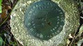
 view gallery view galleryNE24.3 km | Michaud road Section Corner Marker(Federal Land Office Survey) in Public Land Survey Marks Federal Land office Survey marker denoting section corners for sections 28-27/33-34 in T25N R5-E in Michigan! posted by: cachevista location: Michigan date approved: 10/18/2010 last visited: never |
 view gallery view galleryNE24.8 km | Alcona County, Aldrich Road area Federal Land Office Survey(.BADGER) in Public Land Survey Marks Survey marker near horse trail .
I call it BADGER area because of the numerous Badger digs and sightings in this area.(LOTS of porcupines here, too...watch out for your dogs!) posted by: cachevista location: Michigan date approved: 10/12/2010 last visited: never |
 view gallery view gallery SE26.7 km SE26.7 km
|  Whittemore, MI - 48770 Whittemore, MI - 48770
in U.S. Post Offices Small post office located in Whittemore, MI in Iosco County. posted by: bobfrapples8 location: Michigan date approved: 12/28/2021 last visited: never |
 view gallery view gallerySE27 km |  Whittemore Veterans Memorial - Whittemore, MI Whittemore Veterans Memorial - Whittemore, MI
in Non-Specific Veteran Memorials Small town veterans memorial location in Whittemore, MI Iosco County. posted by: bobfrapples8 location: Michigan date approved: 12/28/2021 last visited: never |
 view gallery view gallerySE27 km |  1948 - Whittemore Comm. Hall - Whittemore, MI 1948 - Whittemore Comm. Hall - Whittemore, MI
in Dated Buildings and Cornerstones Brick community hall building from 1948. posted by: bobfrapples8 location: Michigan date approved: 12/28/2021 last visited: never |
 view gallery view gallery N29.9 km N29.9 km
| Oscoda County Honor Roll - Mio, MI in Non-Specific Veteran Memorials Oscoda County Honor Roll located in Mio, Michigan. posted by: Team B Squared location: Michigan date approved: 01/28/2009 last visited: 09/26/2021 |
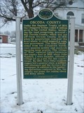 view gallery view galleryN29.9 km | Oscoda County /Oscoda County Courthouse in Michigan Historical Markers Oscoda County /Oscoda County Courthouse is located at 311 S. Morenci Ave. Mio, Oscoda County, Mi. posted by: Jagman714 location: Michigan date approved: 11/18/2006 last visited: 07/07/2014 |
![Image for Pioneer Cemetery [Grant Township]](https://img.geocaching.com/waymarking/small/740139b4-34de-4bb8-9dc5-7775c77d5778.jpg) view gallery view gallery E30.3 km E30.3 km
| Pioneer Cemetery [Grant Township] in Michigan Historical Markers Mounted on a rock on the south side of Old State Road, 1/2 mile west of Sand Lake Road. Parking is available. There is an interesting sign asking "Please... No snowmobiles or ORVs in cemetery." Why would anybody think that is OK? posted by: S5280ft location: Michigan date approved: 05/28/2007 last visited: 10/27/2021 |
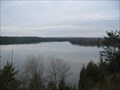 view gallery view galleryN30.7 km |  Mio Scenic Overlook Mio Scenic Overlook
in Scenic Overlooks The Mio Scenic Overlook is off of U.S. 72 in Mio, Mi. posted by: Jagman714 location: Michigan date approved: 11/18/2006 last visited: 11/24/2006 |
 view gallery view galleryN30.9 km |  Mio Dam end of Au Sable River - Mio, Michigan Mio Dam end of Au Sable River - Mio, Michigan
in National Wild and Scenic Rivers The Au Sable River is a designated National Wild and Scenic River Between the Mio Dam and the Alcona Pond. posted by: GT.US location: Michigan date approved: 07/08/2011 last visited: 09/26/2021 |
 view gallery view galleryN31.2 km | Mio Hydroelectric Plant/ Hydroelectric Power in Michigan Historical Markers Mio Hydro Electric Plant is located at Route No. 1, Pond Drive at the Au Sable River. Mio, Mi. posted by: Jagman714 location: Michigan date approved: 11/18/2006 last visited: 09/26/2021 |
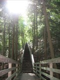 view gallery view galleryE31.4 km |  Iargo Springs Stairway - Iosco County, MI Iargo Springs Stairway - Iosco County, MI
in Outdoor Stairways 300 downward steps to a boardwalk among some beautiful natural springs posted by: Dinoprophet location: Michigan date approved: 09/14/2009 last visited: 10/16/2011 |
|