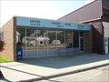
 view gallery view gallery S7.6 km S7.6 km
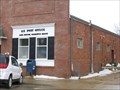
|   Lake Benton, Minnesota 56149 Lake Benton, Minnesota 56149
in U.S. Post Offices Small town post office. Elevation 1789'. Lake Benton is also known as the "Original Wind Power Capital of the Midwest". 600 plus wind turbines grace the skyline along the Buffalo Ridge, bringing clean, renewable energy to the forefront. posted by:  NGComets NGComets location: Minnesota date approved: 05/01/2013 last visited: never |
 view gallery view gallery NE9.8 km NE9.8 km
|  Old Texaco Station - Arco, MN Old Texaco Station - Arco, MN
in Vintage Gas Stations A former Texaco station in Arco, MN. posted by: saopaulo1 location: Minnesota date approved: 08/09/2012 last visited: 05/17/2021 |
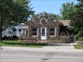
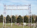
 view gallery view gallery SE13 km SE13 km
| Tyler, Minnesota 56178 in U.S. Post Offices This Post Office is located at 263 N Tyler Street in Tyler, Minnesota. posted by: brwhiz location: Minnesota date approved: 06/29/2013 last visited: never |
 view gallery view gallery SW15.1 km SW15.1 km
|  Buffalo Ridge Wind Farm Buffalo Ridge Wind Farm
in Windmills This gigantic wind farm covers a massive area around Lake Benton Minnesota. posted by: brwhiz location: Minnesota date approved: 07/16/2013 last visited: 06/23/2019 |
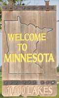 view gallery view gallerySW15.1 km |  Welcome to Minnesota ~ 10,000 Lakes Welcome to Minnesota ~ 10,000 Lakes
in Welcome Signs This Welcome Sign greets you immediately after you have crossed the South Dakota/Minnesota border travelling east on US Highway 14 from Brookings in South Dakota to Lake Benton in Minnesota. posted by: brwhiz location: Minnesota date approved: 07/17/2013 last visited: never |
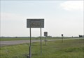 view gallery view gallerySW15.1 km |  Minnesota/South Dakota Border on US Highway 14 Minnesota/South Dakota Border on US Highway 14
in Border Crossings You cross the Minnesota/South Dakota border travelling on US Highway 14 between Lake Benton in Minnesota and Brookings in South Dakota. posted by: brwhiz location: South Dakota date approved: 07/16/2013 last visited: never |
 view gallery view gallerySW15.3 km | Welcome to South Dakota ~ Great Faces. Great Places in Welcome Signs This Welcome Sign greets you immediately after you have crossed the Minnesota/South Dakota border travelling west on US Highway 14 from Lake Benton in Minnesota to Brookings in South Dakota. posted by: brwhiz location: South Dakota date approved: 07/17/2013 last visited: 09/04/2019 |
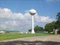 view gallery view gallerySW17.7 km |  Watertower, Elkton, South Dakota Watertower, Elkton, South Dakota
in Water Towers Small town watertower. posted by: NGComets location: South Dakota date approved: 08/17/2010 last visited: never |
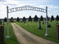 view gallery view gallerySW18.2 km |  St. Mary Cemetery, Elkton, South Dakota St. Mary Cemetery, Elkton, South Dakota
in Worldwide Cemeteries A medium sized Catholic cemetery just east of town.
Elevation 1778 posted by: NGComets location: South Dakota date approved: 06/20/2017 last visited: never |
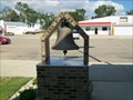 view gallery view gallerySW19 km |  Bell, Fire Department, Elkton, South Dakota Bell, Fire Department, Elkton, South Dakota
in Bells Retired fire department bell in a small town. posted by: NGComets location: South Dakota date approved: 08/19/2010 last visited: 09/26/2010 |
 view gallery view gallerySW19 km |  Firefighters Memorial, Elkton, South Dakota Firefighters Memorial, Elkton, South Dakota
in Firefighter Memorials A lone fireman stands vigil, dedicated to Thomas Kuehl. posted by: NGComets location: South Dakota date approved: 03/07/2012 last visited: never |
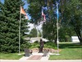
 view gallery view gallerySW19 km |  Memorial for Veterans, Elkton, South Dakota Memorial for Veterans, Elkton, South Dakota
in Non-Specific Veteran Memorials Small town veterans memorial. posted by: NGComets location: South Dakota date approved: 08/19/2010 last visited: never |
 view gallery view gallerySW19 km | Elkton, South Dakota 57026 in U.S. Post Offices Small town post office. posted by: NGComets location: South Dakota date approved: 08/16/2010 last visited: never |
 view gallery view gallerySE20.4 km | Opdahl Kirke Cemetery, Florence, Minnesota in Worldwide Cemeteries Small cemetery just west of Florence, MN, on US Highway 14. Elevation 1718 posted by: NGComets location: Minnesota date approved: 12/20/2018 last visited: never |
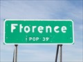 view gallery view gallerySE20.4 km |  Florence, Minnesota - Population 39 Florence, Minnesota - Population 39
in Population Signs Florence was platted in 1888, and named for Florence Sherman, the daughter of a first settler. A post office has been in operation at Florence since 1889.
Elevation 1715 posted by: NGComets location: Minnesota date approved: 11/15/2017 last visited: never |
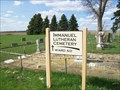 view gallery view gallerySW22.5 km | Immanuel Lutheran Cemetery, Ward, South Dakota in Worldwide Cemeteries A small Lutheran cemetery just a few miles from Ward, SD.
Elevation 1737 posted by: NGComets location: South Dakota date approved: 06/20/2017 last visited: never |
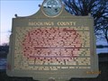 view gallery view gallery NW22.9 km NW22.9 km
|  Brookings County2 Brookings County2
in South Dakota Historical Markers The History of Brookings County began with the Act which authorized its first boundaries approved on April 5th 1862. posted by: MNSearchers location: South Dakota date approved: 04/17/2007 last visited: 10/10/2008 |
 view gallery view galleryNW22.9 km | Lake Hendricks State Park in South Dakota Historical Markers This lake was named for Thomas A Hendricks, commissioner of the General land Office, 1855 - 59, at which time the state boundary was serveyed and the lake named. posted by: MNSearchers location: South Dakota date approved: 04/17/2007 last visited: 10/10/2008 |
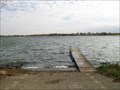 view gallery view galleryNW23.7 km |  Lake Hendricks Boat Ramp, Brookings County, South Dakota Lake Hendricks Boat Ramp, Brookings County, South Dakota
in Boat Ramps A fairly large lake in northeastern Brookings County, South Dakota
Elevation 1766 posted by: NGComets location: South Dakota date approved: 05/09/2019 last visited: never |
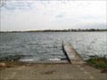 view gallery view galleryNW23.7 km |  Lake Hendricks, Brookings County, South Dakota Lake Hendricks, Brookings County, South Dakota
in Natural Lakes A fairly large lake in northeastern Brookings County, South Dakota
Elevation 1766 posted by: NGComets location: South Dakota date approved: 10/19/2016 last visited: never |
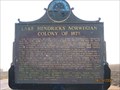 view gallery view galleryNW26.1 km | Lake Hendricks Norwegian Colony of 1873 in South Dakota Historical Markers The first settlers at lake Hendricks were 31 Norwegians, arriving July 14, 1873 with 11 covered wagons and 30 cattle. posted by: MNSearchers location: South Dakota date approved: 04/17/2007 last visited: 07/11/2019 |
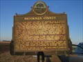 view gallery view galleryNW26.1 km | Brookings County in South Dakota Historical Markers The History of Brookings County began with the Act which authorized its first boundaries approved on April 5th 1862. posted by: MNSearchers location: South Dakota date approved: 04/17/2007 last visited: 04/17/2007 |
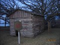
 view gallery view galleryNW26.2 km |  Singsaas Lutheran Church Singsaas Lutheran Church
in U.S. National Register of Historic Places The original Singsaas congregation was formed on October 26th, 1874. posted by: MNSearchers location: South Dakota date approved: 04/17/2007 last visited: 07/11/2019 |
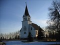 view gallery view galleryNW26.2 km |  Singsaas Lutheran Church - SD Singsaas Lutheran Church - SD
in Country Churches The original Singsaas congregation was formed on October 26th, 1874. posted by: MNSearchers location: South Dakota date approved: 04/17/2007 last visited: 07/11/2019 |
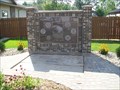
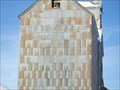 view gallery view gallery W28.5 km W28.5 km
|  Geo. P. Sexauer, Bushnell, South Dakota Geo. P. Sexauer, Bushnell, South Dakota
in Ghost Signs Barely visible on a grain elevator. Elevation 1715'. I worked for this company in the 70's. posted by: NGComets location: South Dakota date approved: 12/28/2015 last visited: never |
|