 view gallery view gallery NE3.9 km NE3.9 km
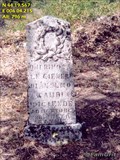
|   Acient cemetery near Clamensane (F) Acient cemetery near Clamensane (F)
in Abandoned Cemeteries A acient cemetry with only two graves left posted by:  FamGrit FamGrit location: Provence-Alpes-Côte d'Azur, France date approved: 01/24/2006 last visited: never |
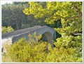
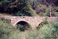 view gallery view galleryNE5 km |  Clamensane Aquaduct Clamensane Aquaduct
in Ancient Aqueducts Ancient Roman auqaduct at 819 m near Clamensane in France. posted by: FamGrit location: France date approved: 01/24/2006 last visited: never |
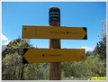
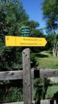
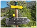 view gallery view galleryNE5.1 km |  845 m - Font Reynier - Clamensane, Paca, France 845 m - Font Reynier - Clamensane, Paca, France
in Elevation Signs Cette altitude est présente sur un panneau à destination des randonneurs posted by: YvesProvence location: Provence-Alpes-Côte d'Azur, France date approved: 01/10/2018 last visited: never |
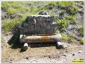 view gallery view galleryNE5.6 km |  Fontaine rustique dans la montagne - Clamensane, Paca, France Fontaine rustique dans la montagne - Clamensane, Paca, France
in Fountains Une fontaine dans la montagne posted by: YvesProvence location: Provence-Alpes-Côte d'Azur, France date approved: 01/10/2018 last visited: never |
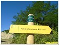
 view gallery view galleryNE6.1 km | 1290 m - Chapelle Saint Amand - Clamensane, Paca, France in Elevation Signs Cette altitude est présente sur un panneau à destination des randonneurs posted by: YvesProvence location: Provence-Alpes-Côte d'Azur, France date approved: 01/10/2018 last visited: never |
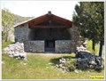
 view gallery view galleryNE6.1 km |  La chapelle Saint Amand - Clamensane, Paca, France La chapelle Saint Amand - Clamensane, Paca, France
in Waychapels La chapelle Saint Amand sur les hauteurs de Clamensane. posted by: YvesProvence location: Provence-Alpes-Côte d'Azur, France date approved: 01/12/2018 last visited: never |
 view gallery view galleryNE6.1 km |  La chapelle Saint Amand - Clamensane, Paca, France La chapelle Saint Amand - Clamensane, Paca, France
in This Old Church La chapelle Saint Amand sur les hauteurs de Clamensane. posted by: YvesProvence location: Provence-Alpes-Côte d'Azur, France date approved: 01/10/2018 last visited: never |
 view gallery view galleryNE6.1 km | La chapelle Saint Amand - Clamensane, Paca, France in Roman Catholic Churches La chapelle Saint Amand sur les hauteurs de Clamensane. posted by: YvesProvence location: Provence-Alpes-Côte d'Azur, France date approved: 01/10/2018 last visited: never |
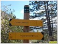 view gallery view galleryNE6.3 km | 1237 m - Col de la Croix - Clamensane, Paca, France in Elevation Signs Cette altitude est présente sur un panneau à destination des randonneurs posted by: YvesProvence location: Provence-Alpes-Côte d'Azur, France date approved: 01/10/2018 last visited: never |
 view gallery view gallery W10.9 km W10.9 km
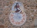
|  Vitruvian Man Sundial, Le Poet, Hautes Alpes, France Vitruvian Man Sundial, Le Poet, Hautes Alpes, France
in Sundials In the hill village of Le Poet in the Laragnais area of Haute Alpes the is a sundial on the village church based on the Vitruvian Man image of Leonardo de Vinci. posted by:  arby101ca arby101ca location: France date approved: 10/23/2009 last visited: never |
 view gallery view gallery NW11.9 km NW11.9 km
| Potey Sundial, Montetier-Allemont, France in Sundials On the caves cooperative in the commune of Montetier-Allemont is an attractive sundial featuring Mother Earth and a cornucopia. This was painted by Rémi Potey in 2000 posted by: arby101ca location: France date approved: 06/02/2010 last visited: 08/20/2017 |
 view gallery view galleryNW12.6 km | Potey Sundial, Ventavon, France in Sundials At the town hall (Marie) of the commune of Ventavon is a sundial painted by Remi Potey in 2000. posted by: arby101ca location: France date approved: 05/29/2010 last visited: never |
 view gallery view galleryW12.9 km |  Le lac de Mison- Upaix- PACA- France Le lac de Mison- Upaix- PACA- France
in Natural Lakes FR: Le lax collinaire de Mison-Upaix- France.
EN: The hill lax of Mison-Upaix- France posted by: SISABIEL location: Provence-Alpes-Côte d'Azur, France date approved: 06/15/2018 last visited: never |
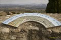 view gallery view galleryW12.9 km |  3 tables orientation à Upaix- Upaix- Hautes-Alpes- PACA- France 3 tables orientation à Upaix- Upaix- Hautes-Alpes- PACA- France
in Orientation Tables 3 tables orientation pour une magnifique vue à 360° posted by: SISABIEL location: Provence-Alpes-Côte d'Azur, France date approved: 11/05/2017 last visited: never |
 view gallery view galleryW12.9 km | Penitents Chapel Sundial, Upaix, Hautes, Alpes, France in Sundials A sundial by Remi Potey on the penitents chapel in Upaix, in the Laragnais of Haute Alpes posted by: arby101ca location: France date approved: 10/23/2009 last visited: 10/21/2017 |
 view gallery view gallery S13 km S13 km
|  44°11'13.8"N 6°02'37.5"E - Le pont de la Reine Jeanne - Entrepierres, France 44°11'13.8"N 6°02'37.5"E - Le pont de la Reine Jeanne - Entrepierres, France
in Permanent Geographic Coordinates Ces coordonnées sont sur un panneau à destination des randonneurs / These coordinates are on a sign for hikers posted by: YvesProvence location: Provence-Alpes-Côte d'Azur, France date approved: 11/15/2021 last visited: 11/03/2021 |
 view gallery view galleryS13 km | 600 m - Le pont de la Reine Jeanne - Entrepierres, France in Elevation Signs Cette altitude est présente sur un panneau à destination des randonneurs / This altitude is present on a sign intended for hikers posted by: YvesProvence location: Provence-Alpes-Côte d'Azur, France date approved: 11/03/2021 last visited: 11/03/2021 |
 view gallery view galleryW13 km | ") Lavoir de Upaix- Hautes-Alpes- PACA- France Lavoir de Upaix- Hautes-Alpes- PACA- France
in Lavoir (wash houses) Lavoir de Upaix. posted by: SISABIEL location: Provence-Alpes-Côte d'Azur, France date approved: 11/05/2017 last visited: never |
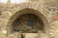
 view gallery view galleryS13 km |  Le pont de la Reine Jeanne - Entrepierre, Paca, France Le pont de la Reine Jeanne - Entrepierre, Paca, France
in People-Named Places Le pont de la Reine Jeanne, sur le Vançon, relie le hameau de Saint-Symphorien (coté sud) au hameau de Vilhosc (coté nord). Il a été payé par la Reine Jeanne pour acheter le silence des habitants posted by: YvesProvence location: Provence-Alpes-Côte d'Azur, France date approved: 07/18/2017 last visited: 11/03/2021 |
 view gallery view galleryS13 km |  Le pont de la Reine Jeanne - Entrepierres - 04 Le pont de la Reine Jeanne - Entrepierres - 04
in Arch Bridges Le pont de la Reine Jeanne, sur le Vançon, relie le hameau de Saint-Symphorien (coté sud) au hameau de Vilhosc (coté nord). Il possède une seule arche et s'appuie sur la roche de chaque côté au point le plus étroit du torrent. posted by: YvesProvence location: Provence-Alpes-Côte d'Azur, France date approved: 01/01/2017 last visited: 11/03/2021 |
 view gallery view galleryS13 km |  Le pont de la Reine Jeanne - Entrepierres - 04 Le pont de la Reine Jeanne - Entrepierres - 04
in Monuments Historiques Français Le pont de la Reine Jeanne, sur le Vançon, relie le hameau de Saint-Symphorien (coté sud) au hameau de Vilhosc (coté nord). Il possède une seule arche et s'appuie sur la roche de chaque côté au point le plus étroit du torrent. posted by: YvesProvence location: Provence-Alpes-Côte d'Azur, France date approved: 01/01/2017 last visited: 11/03/2021 |
 view gallery view galleryS13 km |  Le pont de la Reine Jeanne - Entrepierres - 04 Le pont de la Reine Jeanne - Entrepierres - 04
in Stone Bridges Le pont de la Reine Jeanne, sur le Vançon, relie le hameau de Saint-Symphorien (coté sud) au hameau de Vilhosc (coté nord). Il possède une seule arche et s'appuie sur la roche de chaque côté au point le plus étroit du torrent. posted by: YvesProvence location: Provence-Alpes-Côte d'Azur, France date approved: 01/13/2017 last visited: 11/03/2021 |
 view gallery view galleryW13 km | 630 m. Lac de Mison- Mison- Alpes de Hautes Provence- PACA- France in Elevation Signs FR: Panneau indicateur pour les randonneurs. EN: Signpost for hikers. posted by: SISABIEL location: Provence-Alpes-Côte d'Azur, France date approved: 06/01/2018 last visited: never |
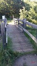 view gallery view galleryW13 km |  Le petit pont en bois du lac de Mison- Alpes de Hautes Provence Le petit pont en bois du lac de Mison- Alpes de Hautes Provence
in Hiking Path Footbridges FR: Le petit pont en bois du lac de Mison.
EN: The little wooden bridge of Lake Mison. posted by: SISABIEL location: Provence-Alpes-Côte d'Azur, France date approved: 06/03/2018 last visited: never |
 view gallery view galleryS13.4 km | 700 m - Saint Symphorien - Entrepierre, France in Elevation Signs Cette altitude est présente sur un panneau à destination des randonneurs / This altitude is present on a sign intended for hikers posted by: YvesProvence location: Provence-Alpes-Côte d'Azur, France date approved: 11/10/2021 last visited: 11/10/2021 |
|