 view gallery view gallery SE13 km SE13 km
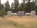
|   Welcome to Upton - Best Town On Earth Welcome to Upton - Best Town On Earth
in Welcome Signs The town of Upton Wyoming proudly declares itself "Best Town on Earth" posted by:  BruceS BruceS location: Wyoming date approved: 08/31/2007 last visited: never |
 view gallery view gallery NW20 km NW20 km
|  Moorcroft, Wyoming, 82721 Moorcroft, Wyoming, 82721
in U.S. Post Offices US Post Office in Moorcroft, Wyoming. Near Interstate 90. posted by:  team coldwine team coldwine location: Wyoming date approved: 05/26/2012 last visited: never |
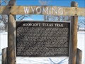 view gallery view galleryNW22.2 km |  Moorcroft Texas Trail - Moorcroft, WY Moorcroft Texas Trail - Moorcroft, WY
in Wyoming Historical Markers This historical marker is located in the rest area off I-90 at the Moorcroft exit. It describes the history of the Moorcroft Texas Trail posted by:  onfire4jesus onfire4jesus location: Wyoming date approved: 08/26/2013 last visited: 06/14/2015 |
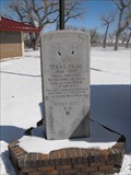 view gallery view galleryNW22.2 km | Texas Trail - Moorcroft, WY in Wyoming Historical Markers This stone historical marker is located in the rest area off I-90 in Moorcroft. It gives a brief history of the trail used to bring cattle to Wyoming from texas. posted by: onfire4jesus location: Wyoming date approved: 08/26/2013 last visited: 06/14/2015 |
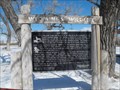 view gallery view galleryNW22.2 km |  Lifeline - Wyoming Wildlife - Moorcroft, WY Lifeline - Wyoming Wildlife - Moorcroft, WY
in Flora and Fauna Information Signs This sign describes the local flora and fauna of this region and how the rivers are a lifeline for them. It is located at the rest area off I-90 at Moorcroft, WY posted by: onfire4jesus location: Wyoming date approved: 07/15/2013 last visited: 08/30/2019 |
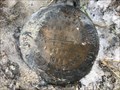
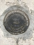 view gallery view galleryNW31.5 km |  R 358 (PV0416) - Campbell County, Wyoming R 358 (PV0416) - Campbell County, Wyoming
in U.S. Benchmarks This benchmark is set in the side of an interstate highway bridge pier. posted by: Tom.dog location: Wyoming date approved: 01/08/2023 last visited: never |
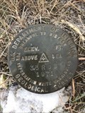 view gallery view gallery W32.7 km W32.7 km
| 33 RGB (PV0585) - Campbell County, Wyoming in U.S. Benchmarks A U.S. Department of Interior Geological Survey benchmark on the south side of O R Road. posted by: Tom.dog location: Wyoming date approved: 01/08/2023 last visited: never |
 view gallery view galleryW34.6 km | Q 358 (PV0415) - Campbell County, Wyoming in U.S. Benchmarks A metal rod in the southwest quadrant of the Stewart Road crossing over the BNSF railroad tracks. posted by: Tom.dog location: Wyoming date approved: 01/08/2023 last visited: never |
 view gallery view galleryW35.7 km | P 358 (PV0414) - Campbell County, Wyoming in U.S. Benchmarks A metal rod on the south side of State Highway 51. posted by: Tom.dog location: Wyoming date approved: 01/08/2023 last visited: never |
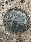 view gallery view galleryW37.5 km | Z 120 (PV0220) - Campbell County, Wyoming in U.S. Benchmarks This benchmark is between State Highway 51 and the BNSF railroad tracks about one mile east of Rozet, Wyoming. posted by: Tom.dog location: Wyoming date approved: 01/08/2023 last visited: never |
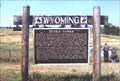
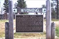
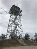 view gallery view gallery NE42.2 km NE42.2 km
|  Warren Peak Fire Lookout - Crook County, Wyoming Warren Peak Fire Lookout - Crook County, Wyoming
in Look-Out Towers The Warren Peak Fire Lookout is located atop the highest point in the Bear Lodge Mountains of northeastern Wyoming. posted by: Tom.dog location: Wyoming date approved: 07/30/2023 last visited: never |
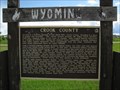 view gallery view galleryNE42.5 km | Crook County - Crook County, WY in Wyoming Historical Markers This historical marker is located in a rest area near the state border with South Dakota. posted by: gparkes location: Wyoming date approved: 07/13/2009 last visited: 07/06/2016 |
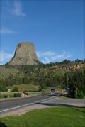
 view gallery view gallery N44.4 km N44.4 km
| Devils Tower in Wyoming Historical Markers Marker about the geology and lore of the Tower. posted by: YoSam. location: Wyoming date approved: 02/18/2008 last visited: 04/09/2022 |
 view gallery view galleryN44.4 km | Another Devils Tower in Wyoming Historical Markers Almost across the hwy. from the other Devil Tower marker, this one deals with the human side of history and lore. posted by: YoSam. location: Wyoming date approved: 02/18/2008 last visited: 06/10/2021 |
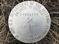
 view gallery view galleryW44.6 km |  T48N R70W S32 T47N S5 1/4 - Campbell County, Wyoming T48N R70W S32 T47N S5 1/4 - Campbell County, Wyoming
in Public Land Survey Marks This USDI-Bureau of Land Management quarter corner marker is located on the south slope of the Caballo Creek drainage. posted by: Tom.dog location: Wyoming date approved: 02/05/2023 last visited: never |
 view gallery view galleryW45.2 km | T48N R70W S31 S32 1/4 - Campbell County, Wyoming in Public Land Survey Marks This USDI-Bureau of Land Management quarter corner marker is just to the southwest of a bend in Bishop Road. posted by: Tom.dog location: Wyoming date approved: 02/05/2023 last visited: never |
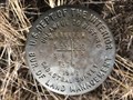 view gallery view galleryW45.4 km | T48N R70W S31 S32 T47N S5 S6 - Campbell County, Wyoming in Public Land Survey Marks This USDI-Bureau of Land Management section corner marker is located where Dugout Draw intersects the Caballo Creek drainage. posted by: Tom.dog location: Wyoming date approved: 02/05/2023 last visited: never |
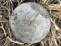 view gallery view galleryW46.2 km | T48N R70W S31 T47N S6 1/4 - Campbell County, Wyoming in Public Land Survey Marks This USDI-Bureau of Land Management quarter corner marker is located on the south side of the Caballo Creek drainage. posted by: Tom.dog location: Wyoming date approved: 02/05/2023 last visited: never |
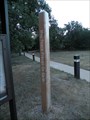 view gallery view galleryN46.8 km |  Devils Tower Peace Pole - Devils Tower, Wyoming Devils Tower Peace Pole - Devils Tower, Wyoming
in Peace Poles The Peace Pole at Devils Tower National Monument. posted by: paulspaper location: South Dakota date approved: 08/05/2016 last visited: 10/08/2021 |
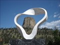 view gallery view galleryN46.8 km |  Devils Tower, Framed - Devils Tower, WY Devils Tower, Framed - Devils Tower, WY
in Framed Views The Circle of Sacred Smoke sculpture frames Devils Tower. posted by: Team2002 location: Wyoming date approved: 04/14/2014 last visited: 10/08/2021 |
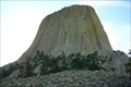 view gallery view galleryN47 km |  Devils Tower National Monument - Devils Tower, Wyoming Devils Tower National Monument - Devils Tower, Wyoming
in Geological Devilish Locations Located in northeastern Wyoming Devils Tower National Monument was the 1st National Monument in the US. It's key feature is the the 867 feet tall stone monolith which dominates the landscape for miles around.
posted by: Hikenutty location: Wyoming date approved: 07/13/2007 last visited: 09/22/2023 |
 view gallery view galleryN47 km | ") Devil's Tower National Monument - Wyoming Devil's Tower National Monument - Wyoming
in National Parks (U.S.) Devil's Tower, the nation's first National Monument, was formed over 60 million years ago when molten magma forced it's way up and then cooled. Over the years the softer rock and soil around it eroded, leaving the 867' basalt monolith we see today. posted by: Hikenutty location: Wyoming date approved: 07/13/2007 last visited: 09/22/2023 |
 view gallery view galleryN47 km |  Devil's Tower National Monument - Wyoming Devil's Tower National Monument - Wyoming
in National Parks of the World Devil's Tower National Monument was the first National Monument in the United States, established in 1906 by Theodore Roosevelt. The tower is an 847 foot basalt monolith formed over 60 million years ago.
posted by: Hikenutty location: Wyoming date approved: 07/13/2007 last visited: 09/22/2023 |
 view gallery view galleryN47 km |  Devil's Tower - Devil's Tower, Wyoming Devil's Tower - Devil's Tower, Wyoming
in Places of Geologic Significance Devil's Tower was formed over 60 million years ago when molten magma forced it's way up through sedimentary rocks and then cooled. Over the years the softer rock and soil eroded, leaving the 867' monolith we see today. posted by: Hikenutty location: Wyoming date approved: 07/13/2007 last visited: 09/22/2023 |
 view gallery view galleryN47 km |  Devil's Tower National Monument - Wyoming Devil's Tower National Monument - Wyoming
in American Guide Series Located in northeastern Wyoming Devils Tower National Monument was the 1st National Monument in the US. It's key feature is the the 867 feet tall stone monolith which dominates the landscape for miles around. posted by: Hikenutty location: Wyoming date approved: 08/25/2007 last visited: 09/22/2023 |
|