 view gallery view gallery SE6.4 km SE6.4 km
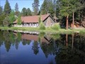
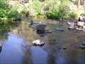
|   Shevlin Park - Bend, OR Shevlin Park - Bend, OR
in Municipal Parks and Plazas Shevlin Park (652 acres) is located less than five miles from downtown Bend and a perfect location for hiking, jogging, fishing, cross country skiing and picnicking. posted by:  Volcanoguy Volcanoguy location: Oregon date approved: 06/09/2006 last visited: 06/10/2006 |
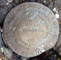
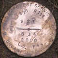 view gallery view gallerySE6.4 km |  T 17 S, R 11 E, 1/4 corner between sections 27 & 34, Oregon T 17 S, R 11 E, 1/4 corner between sections 27 & 34, Oregon
in U.S. Benchmarks Corner cap for T 17 S, R 11 E, 1/4 corner between sections 27 & 34. posted by: Volcanoguy location: Oregon date approved: 06/13/2006 last visited: 06/14/2006 |
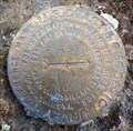
 view gallery view gallery E6.4 km E6.4 km
| T 17 S, R 11 E, Center 1/4 of section 23, Oregon in U.S. Benchmarks Caps for T 17 S, R 11 E, center 1/4 corner of section 23. posted by: Volcanoguy location: Oregon date approved: 06/09/2006 last visited: 06/10/2006 |
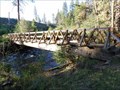 view gallery view gallerySE6.4 km |  Shevlin Park, Lower Bridge - Oregon Shevlin Park, Lower Bridge - Oregon
in Hiking Path Footbridges Lower footbridge in Shevlin Park, west of Bend, Oregon. posted by: Volcanoguy location: Oregon date approved: 09/07/2011 last visited: 08/11/2011 |
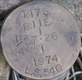 view gallery view gallerySE6.6 km | T 17 S, R 11 E, 1/4 corner between sections 26 & 27, Oregon in U.S. Benchmarks Corner cap for T 17 S, R 11 E, 1/4 corner between sections 26 & 27. posted by: Volcanoguy location: Oregon date approved: 06/13/2006 last visited: 06/14/2006 |
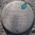 view gallery view galleryE6.6 km | Tumalo Creek Gage Datum, Oregon in U.S. Benchmarks Stream gage datum on Tumalo Creek. posted by: Volcanoguy location: Oregon date approved: 06/09/2006 last visited: 06/10/2006 |
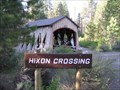 view gallery view gallerySE6.6 km |  Hixon Crossing Covered Bridge, Oregon Hixon Crossing Covered Bridge, Oregon
in Covered Bridges Cover bridge across Tumalo Creek in Shevlin Park. posted by: Volcanoguy location: Oregon date approved: 06/24/2006 last visited: 05/12/2022 |
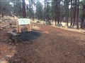
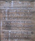 view gallery view gallerySE6.8 km |  Fremont Meadow Fremont Meadow
in Oregon Historical Markers Fremont Meadow is located in Shevlin Park. posted by: Volcanoguy location: Oregon date approved: 06/13/2006 last visited: 06/13/2006 |
 view gallery view gallerySE7.4 km | Three Pines Park - Bend, Oregon in Municipal Parks and Plazas Small neighborhood park in the Three Pines subdivision on the Bend westside. posted by: Volcanoguy location: Oregon date approved: 09/08/2011 last visited: 08/11/2011 |
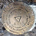 view gallery view gallery S7.6 km S7.6 km
| QD1708 - USCGS FIRST 1945 - Oregon in U.S. Benchmarks U.S. Coast & Geodetic Survey triangulation station FIRST. posted by: Volcanoguy location: Oregon date approved: 11/01/2015 last visited: 10/31/2015 |
 view gallery view galleryS7.6 km | QD1708 - USCGS FIRST NO 1 1945 - Oregon in U.S. Benchmarks U.S. Coast & Geodetic Survey reference mark FIRST NO 1. posted by: Volcanoguy location: Oregon date approved: 11/01/2015 last visited: 10/31/2015 |
 view gallery view galleryS7.6 km | QD1708 - USCGS FIRST NO 2 1945 - Oregon in U.S. Benchmarks U.S. Coast & Geodetic Survey reference mark FIRST NO 2. posted by: Volcanoguy location: Oregon date approved: 11/01/2015 last visited: 10/31/2015 |
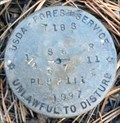 view gallery view galleryS7.9 km | T 18 S, R 11 E, 1/4 Cor. 6, 7 - Oregon in U.S. Benchmarks USDA Forest Service quarter corner. posted by: Volcanoguy location: Oregon date approved: 11/01/2015 last visited: 10/31/2015 |
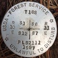 view gallery view galleryS7.9 km | T 18 S, R 10-11 E, Sec. Cor. 1, 6, 7, 12 - Oregon in U.S. Benchmarks USDA Forest Service section corner. posted by: Volcanoguy location: Oregon date approved: 11/01/2015 last visited: 10/31/2015 |
 view gallery view gallerySE8.4 km | Quail Park - Bend, OR in Municipal Parks and Plazas This neighborhood park is located at 2755 NW Regency Street. posted by: Volcanoguy location: Oregon date approved: 03/28/2007 last visited: 03/29/2007 |
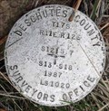 view gallery view galleryE8.5 km | Section Corner T17S, R11-12E, Sections 12, 7, 18, 13 - 1987 - Oregon in U.S. Benchmarks Deschutes County Surveyors Office section corner T17S, R11-12E, Sections 12, 7, 18, 13 posted by: Volcanoguy location: Oregon date approved: 02/06/2013 last visited: 12/15/2012 |
 view gallery view galleryE8.7 km | T 17 S, R 11-12 E, N 1/16 Corner between Section 12 & 7, Oregon in U.S. Benchmarks Cadastral cap for T 17 S, R 11-12 E, N 1/16 Corner between 12 & 7 posted by: Volcanoguy location: Oregon date approved: 07/01/2007 last visited: 07/01/2007 |
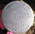
![Image for SNOW AZ MK 2 [CF4903] -- Deschutes County, OR](https://img.geocaching.com/waymarking/small/8d8eb0ba-dac4-4d91-832d-0c76fa6c18c4.jpg) view gallery view gallery NE8.9 km NE8.9 km
|  SNOW AZ MK 2 [CF4903] -- Deschutes County, OR SNOW AZ MK 2 [CF4903] -- Deschutes County, OR
in Azimuth Benchmarks NGS Azimuth Mark brass cap stamped SNOW 1945 AZ 2 1976, set in a 9x9" concrete monument posted by: Cooke17513 location: Oregon date approved: 02/06/2012 last visited: never |
 view gallery view gallerySE8.9 km | T 18 S, R 11 E, 1/4 Cor 3, 2 - Oregon in U.S. Benchmarks Bureau of Land Management 1/4 corner. posted by: Volcanoguy location: Oregon date approved: 04/30/2020 last visited: 11/01/2019 |
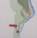
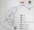 view gallery view galleryE8.9 km |  Riley Ranch Nature Reserve - Canyon Loop Junction - Bend, Oregon Riley Ranch Nature Reserve - Canyon Loop Junction - Bend, Oregon
in 'You Are Here' Maps You Are Here marker on map on trail junction sign at Riley Ranch Nature Reserve. posted by: Volcanoguy location: Oregon date approved: 12/21/2017 last visited: 11/25/2017 |
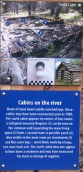 view gallery view galleryE8.9 km | Cabins on the river - Bend, Oregon in Oregon Historical Markers History sign at Riley Ranch Nature Reserve, Bend, Oregon. posted by: Volcanoguy location: Oregon date approved: 12/23/2017 last visited: 11/25/2017 |
 view gallery view galleryE8.9 km | Tumalo State Park Bounday Marker (3), Oregon in U.S. Benchmarks State Park Boundary Marker for park property in Section 7 of T17S, R12E. posted by: Volcanoguy location: Oregon date approved: 07/01/2007 last visited: 07/01/2007 |
 view gallery view galleryE8.9 km |  CONFLUENCE - Tumalo Creek - Deschutes River CONFLUENCE - Tumalo Creek - Deschutes River
in River Origins, Destinations and Confluences Tumalo Creek flows into the Deschutes River in a 200 foot deep canyon near Bend, Oregon. posted by: Volcanoguy location: Oregon date approved: 06/23/2007 last visited: 06/23/2007 |
 view gallery view galleryE9 km | Riley Ranch Nature Reserve - North Trailhead - Bend, Oregon in 'You Are Here' Maps You Are Here marker on map on “Welcome to Riley Ranch Nature Reserve” sign. posted by: Volcanoguy location: Oregon date approved: 12/21/2017 last visited: 11/25/2017 |
 view gallery view galleryE9 km |  North Trailhead - Riley Ranch Nature Reserve - Bend, Oregon North Trailhead - Riley Ranch Nature Reserve - Bend, Oregon
in Hiking and walking trailheads A secondary trailhead at Riley Ranch Nature Reserve in northwest Bend, OR. posted by: Volcanoguy location: Oregon date approved: 12/30/2017 last visited: 11/25/2017 |
|