 view gallery view gallery N0.2 km N0.2 km
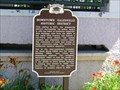
|   Downtown Galesville Historic District Downtown Galesville Historic District
in Wisconsin Historical Markers Downtown Galesville Historic District marker in downtown Galesville in Trempeleau County posted by:  frankhj frankhj location: Wisconsin date approved: 03/02/2012 last visited: never |
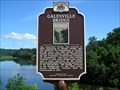 view gallery view galleryN0.3 km | Galesville Bridge in Wisconsin Historical Markers Galesville Bridge Marker in Galesville, Trempeauleau County posted by: frankhj location: Wisconsin date approved: 08/11/2014 last visited: never |
 view gallery view gallery W0.8 km W0.8 km
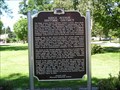
| Ridge Avenue Historic District in Wisconsin Historical Markers Ridge Avenue Historic District Marker Galesville, WI posted by: frankhj location: Wisconsin date approved: 04/19/2012 last visited: never |
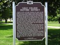 view gallery view galleryW1.4 km | Galesville College in Wisconsin Historical Markers Galesville College Marker in Galesville, Trempealeau County posted by: frankhj location: Wisconsin date approved: 08/11/2014 last visited: never |
 view gallery view gallery SE2.4 km SE2.4 km
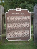
| DECORAH PEAK in Wisconsin Historical Markers Across the highway to the east is where Winnebago Chief, One-Eyed Decorah took refuge in a cave near the peak after being wounded in a Chippewa attack on his village. posted by:  Archived2012 Archived2012 location: Wisconsin date approved: 09/04/2007 last visited: 06/23/2002 |
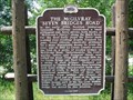 view gallery view gallerySE7.6 km | The McGilvray "Seven Bridges Road" in Wisconsin Historical Markers The McGilvray "Seven Bridges Road" Marker in the Van Loon State Wildlife Area. posted by: frankhj location: Wisconsin date approved: 08/05/2008 last visited: 10/12/2008 |
 view gallery view gallery SW10.6 km SW10.6 km
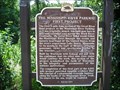
| The Mississippi River Parkway: First Project in Wisconsin Historical Markers Mississippi River Parkway Marker on the Great River State Trail off of Hwy 35, 1/2 mi. E of Trempealeau. posted by: frankhj location: Wisconsin date approved: 08/05/2008 last visited: 06/28/2009 |
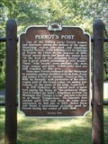 view gallery view gallerySW12.4 km | PERROT'S POST in Wisconsin Historical Markers Perrot spent the winter here in 1685, "at the foot of the mountain behind which was a great prairie abounding in wild beasts". posted by: Archived2012 location: Wisconsin date approved: 09/04/2007 last visited: 06/28/2009 |
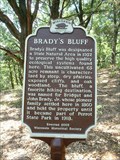 view gallery view gallerySW12.6 km | BRADY'S BLUFF in Wisconsin Historical Markers The bluff was named for Bridget and John Brady Jr. whose pioneer family settled here in 1860 and held the property until it became part of Perrot State Park in 1918. posted by: Archived2012 location: Wisconsin date approved: 09/04/2007 last visited: 09/02/2011 |
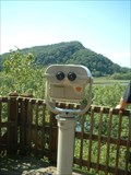 view gallery view gallerySW12.7 km |  Perrot State Park Overlook Area Perrot State Park Overlook Area
in Coin-Op Binoculars Located in Perrot State Park at one of the Overlook areas. You will need a park sticker to enter the park or pay a day fee at the Station when you enter the park. posted by: Archived2012 location: Wisconsin date approved: 09/08/2007 last visited: 09/02/2011 |
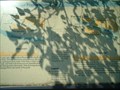 view gallery view gallerySW12.9 km |  Geology of Perrot State Park Geology of Perrot State Park
in 'You Are Here' Maps You are on an observation deck at Perrot State Park. You will need a park sticker or get a hour or day pass at the Station when you enter the park. posted by: Archived2012 location: Wisconsin date approved: 09/07/2007 last visited: 06/28/2009 |
 view gallery view gallery S15.9 km S15.9 km
|  Great River Campground - Winona, Minn. Great River Campground - Winona, Minn.
in Campgrounds Tent and RV camping in Great River Bluffs State Park. posted by: msrubble location: Minnesota date approved: 07/17/2019 last visited: never |
 view gallery view gallerySW16.3 km |  Pickwick Mill – Winona, MN Pickwick Mill – Winona, MN
in Water Mills When Pickwick Flour Mill was still being constructed, it was named by Mary Davis after reading Charles Dickens’ novel, Pickwick Papers. posted by: wildernessmama location: Minnesota date approved: 07/10/2016 last visited: never |
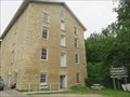 view gallery view gallerySW16.3 km |  Pickwick Mill – Winona, MN Pickwick Mill – Winona, MN
in U.S. National Register of Historic Places When Pickwick Flour Mill was still being constructed, it was named by Mary Davis after reading Charles Dickens’ novel, Pickwick Papers. posted by: wildernessmama location: Minnesota date approved: 07/08/2016 last visited: never |
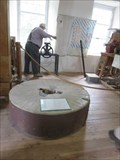 view gallery view gallerySW16.3 km |  Pickwick Millstones – Winona, MN Pickwick Millstones – Winona, MN
in Millstones These millstones are on display in the Pickwick Flour Mill in rural Winona. posted by: wildernessmama location: Minnesota date approved: 07/07/2016 last visited: never |
 view gallery view galleryW16.4 km |  Twin Palindrome - Winona, Wisconsin Twin Palindrome - Winona, Wisconsin
in Coordinate Palindromes This palindrome is located in a Trempealeau Marshland Preserve. posted by: annakido location: Wisconsin date approved: 10/16/2006 last visited: 10/30/2007 |
 view gallery view gallerySE16.4 km | Luther College in Wisconsin Historical Markers Luther College Marker, corner of Hwys D & W E. of Holmen. posted by: frankhj location: Wisconsin date approved: 08/05/2008 last visited: 09/26/2013 |
 view gallery view galleryS16.6 km |  Great River Bluffs State Park - Winona, Minn. Great River Bluffs State Park - Winona, Minn.
in State Park Passport Locations Where to get your Passport Club book stamped at Great River Bluffs State Park. posted by: msrubble location: Minnesota date approved: 07/22/2019 last visited: 11/03/2020 |
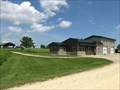 view gallery view galleryS16.6 km |  Great River Bluffs State Park Ranger Station - Winona, Minn. Great River Bluffs State Park Ranger Station - Winona, Minn.
in Ranger Stations Park office at Great River Bluffs State Park. posted by: msrubble location: Minnesota date approved: 07/18/2019 last visited: never |
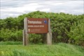 view gallery view galleryW18.3 km |  Trempealeau NWR - Buffalo WI Trempealeau NWR - Buffalo WI
in National Wildlife Refuges The signs are located along the Great River Rd. The turn off to the VC is Refuge Rd. Easy to miss. posted by: nomadwillie location: Wisconsin date approved: 09/12/2015 last visited: never |
 view gallery view gallery NW21.6 km NW21.6 km
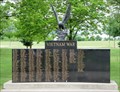
|  Vietnam War Memorial, Memorial Park, Arcadia, WI, USA Vietnam War Memorial, Memorial Park, Arcadia, WI, USA
in Vietnam War Memorials Two section Vietnam war memorial along the Soldiers Walk of the Arcadia, Wisconsin, Memorial Park. posted by: HANSENNI location: Wisconsin date approved: 08/25/2009 last visited: 10/10/2010 |
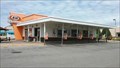 view gallery view galleryW22.2 km |  A&W - Winona, Minnesota A&W - Winona, Minnesota
in A + W Restaurants This location has dine-in, drive-thru, and two rows of drive-up car service. posted by: SageInThyme82 location: Minnesota date approved: 08/14/2020 last visited: 08/06/2020 |
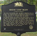 view gallery view galleryW23 km |  Sugar Loaf Bluff - Winona, MN Sugar Loaf Bluff - Winona, MN
in Minnesota Historical Markers This historical marker is located in a city park on the outskirts of Winona, MN. posted by: onfire4jesus location: Minnesota date approved: 10/16/2008 last visited: 06/23/2016 |
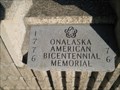 view gallery view gallerySE23 km |  Onalaska Community Park time Capsule - Onalaska, WI Onalaska Community Park time Capsule - Onalaska, WI
in Time Capsules Located under the flag pole in the Community Park. posted by: skree location: Wisconsin date approved: 08/25/2011 last visited: never |
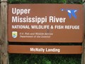 view gallery view galleryW23 km | Upper Mississippi River National Wildlife & Fish Refuge - Mertes Slough - Wisconsin in National Wildlife Refuges Electric motor only area provides a different experience on the Mississippi River. posted by: Refuge Ranger location: Wisconsin date approved: 06/24/2011 last visited: never |
|