 view gallery view gallery SW3.7 km SW3.7 km
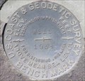
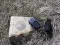
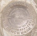
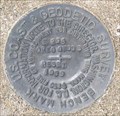
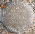
|   QD1262 - USCGS W111, OR QD1262 - USCGS W111, OR
in U.S. Benchmarks USCGS benchmark W111 along Ore. Hwy. 27. posted by:  Volcanoguy Volcanoguy location: Oregon date approved: 04/14/2008 last visited: 04/22/2011 |
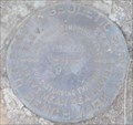
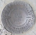 view gallery view gallery W4.8 km W4.8 km
| QD1260 - USCGS V111, OR in U.S. Benchmarks USCGS benchmark V111 along old segment of Ore. Hwy. 27. posted by: Volcanoguy location: Oregon date approved: 04/14/2008 last visited: 04/14/2008 |
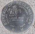 view gallery view gallery NW8.9 km NW8.9 km
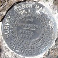
| BOR - Bowman Dam Benchmark, Oregon in U.S. Benchmarks Bureau of Reclamation BM at Bowman Dam, Oregon. posted by: Volcanoguy location: Oregon date approved: 04/09/2008 last visited: 04/09/2008 |
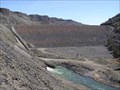 view gallery view galleryNW8.9 km |  Bowman Dam/Prineville Reservoir, Oregon Bowman Dam/Prineville Reservoir, Oregon
in Water Dams Bureau of Reclamation’s Arthur R. Bowman Dam and Prineville Reservoir. posted by: Volcanoguy location: Oregon date approved: 04/07/2008 last visited: 04/08/2008 |
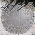
 view gallery view gallery S9 km S9 km
| QD1270 - USCGS Y111, OR in U.S. Benchmarks USCGS benchmark Y111 along Ore. Hwy. 27. posted by: Volcanoguy location: Oregon date approved: 04/14/2008 last visited: 04/22/2011 |
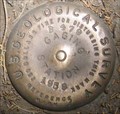
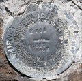
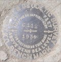
 view gallery view galleryNW10 km | QD0309 - USCGS U111, OR in U.S. Benchmarks USCGS Benchmark U111 posted by: Volcanoguy location: Oregon date approved: 08/07/2008 last visited: 08/07/2008 |
 view gallery view galleryNW13.5 km | QD0301 - USGS B479, OR in U.S. Benchmarks USGS Reference Mark B479 posted by: Volcanoguy location: Oregon date approved: 08/06/2008 last visited: 08/06/2008 |
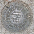 view gallery view galleryNW13.7 km | QD0303 - USCGS G294 RESET, OR in U.S. Benchmarks USCGS Benchmark G294 RESET posted by: Volcanoguy location: Oregon date approved: 08/07/2008 last visited: 08/07/2008 |
 view gallery view galleryNW13.7 km | QD0300 - USCGS T111, OR in U.S. Benchmarks USCGS Benchmark T111 posted by: Volcanoguy location: Oregon date approved: 08/06/2008 last visited: 08/06/2008 |
 view gallery view galleryNW14.6 km | QD0299 - USCGS F294 RESET, OR in U.S. Benchmarks USCGS Benchmark F294 RESET posted by: Volcanoguy location: Oregon date approved: 08/06/2008 last visited: 08/06/2008 |
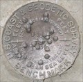
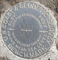
 view gallery view galleryS15 km | PB0158 - USCGS A112, OR in U.S. Benchmarks USCGS benchmark A112 along Ore. Hwy. 27.
posted by: Volcanoguy location: Oregon date approved: 04/14/2008 last visited: 04/22/2011 |
 view gallery view galleryNW15.9 km | QD0297 - USCGS H481 RESET, OR in U.S. Benchmarks USCGS Benchmark H481 RESET posted by: Volcanoguy location: Oregon date approved: 08/03/2008 last visited: 08/04/2008 |
 view gallery view galleryNW17.4 km | QD0295 - USCGS E294 RESET, OR in U.S. Benchmarks USCGS Benchmark E294 RESET posted by: Volcanoguy location: Oregon date approved: 08/03/2008 last visited: 08/03/2008 |
 view gallery view galleryS17.9 km | PB0159 - USCGS B112, OR in U.S. Benchmarks USCGS benchmark B112 along Ore. Hwy. 27. posted by: Volcanoguy location: Oregon date approved: 04/14/2008 last visited: 04/22/2011 |
 view gallery view galleryW18.7 km | Perreualt, Oregon in U.S. Benchmarks Deschutes County Surveyors Office disk stamped Perreualt. posted by: Volcanoguy location: Oregon date approved: 04/09/2008 last visited: 04/22/2011 |
 view gallery view galleryS20 km | PB0160 - USCGS C112, OR in U.S. Benchmarks USCGS benchmark C112 along Ore. Hwy. 27. posted by: Volcanoguy location: Oregon date approved: 04/14/2008 last visited: 04/14/2008 |
 view gallery view galleryNW21.2 km | QD0291 - USCGS G481, OR in U.S. Benchmarks USCGS Benchmark G481 posted by: Volcanoguy location: Oregon date approved: 08/03/2008 last visited: 08/03/2008 |
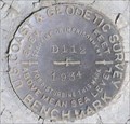 view gallery view galleryS23 km | PB0161 - USCGS D112, OR in U.S. Benchmarks USCGS benchmark D112 along Ore. Hwy. 27. posted by: Volcanoguy location: Oregon date approved: 04/14/2008 last visited: 04/14/2008 |
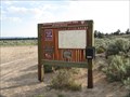 view gallery view galleryW24.3 km |  Badlands, near Alfalfa, OR (Dry River Trailhead) Badlands, near Alfalfa, OR (Dry River Trailhead)
in 'You Are Here' Maps This "You Are Here" map is on the sign board for the Dry River Trailhead, part of the Oregon Badlands, near the tiny town of Alfalfa. posted by: Queens Blessing location: Oregon date approved: 08/01/2009 last visited: 09/02/2013 |
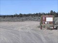 view gallery view galleryW24.3 km |  Badlands, Dry River Trailhead, OR Badlands, Dry River Trailhead, OR
in Public Access Lands The Dry River Trailhead provides access to the Dry River Trail. posted by: Volcanoguy location: Oregon date approved: 04/07/2008 last visited: 07/04/2009 |
 view gallery view gallery N24.5 km N24.5 km
| Bureau of Reclamation OCH3 in U.S. Benchmarks Bureau of Reclamation benchmark near Ochoco reservoir dam posted by: tsasquier location: Oregon date approved: 02/08/2009 last visited: never |
 view gallery view galleryS25.4 km | PB0088 - ODOT 25, Oregon in U.S. Benchmarks Oregon Department of Transportation benchmark 25. posted by: Volcanoguy location: Oregon date approved: 02/24/2009 last visited: 02/24/2009 |
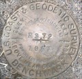 view gallery view gallerySW25.4 km | PB0087 - USCGS R372, Oregon in U.S. Benchmarks U.S. Coast & Geodetic Survey benchmark R372. posted by: Volcanoguy location: Oregon date approved: 02/24/2009 last visited: 02/24/2009 |
 view gallery view galleryS25.4 km | PB0090 - USCGS S372, Oregon in U.S. Benchmarks U.S. Coast & Geodetic Survey benchmark S372. posted by: Volcanoguy location: Oregon date approved: 02/24/2009 last visited: 02/24/2009 |
 view gallery view galleryS25.6 km | PB0092 - ODOT 26, Oregon in U.S. Benchmarks Oregon Department of Transportation benchmark 26. posted by: Volcanoguy location: Oregon date approved: 02/24/2009 last visited: 02/24/2009 |
|