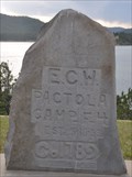
 view gallery view gallery NE3.2 km NE3.2 km
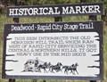
|   Deadwood-Rapid City Stage Trail Deadwood-Rapid City Stage Trail
in South Dakota Historical Markers This Historical marker is located on the west side of Cavern Road a short distance north of South Dakota Highway 44 west of Rapid City, South Dakota. posted by:  brwhiz brwhiz location: South Dakota date approved: 10/08/2013 last visited: 07/06/2014 |
 view gallery view galleryNE3.2 km |  Deadwood-Rapid City Stage Trail Deadwood-Rapid City Stage Trail
in Wagon Roads and Trails This Historical marker about the Deadwood-Rapid City Stage Trail is located on the west side of Cavern Road a short distance north of South Dakota Highway 44 west of Rapid City, South Dakota. posted by: brwhiz location: South Dakota date approved: 03/08/2013 last visited: never |
 view gallery view gallery SE5.5 km SE5.5 km
|  T1NR6E - BHNF Big Horn Sheep Management Area T1NR6E - BHNF Big Horn Sheep Management Area
in U.S. Benchmarks Boundary monument/disk located at a gate that enters National Forest land where a herd of big horn sheep is located/managed. posted by: HikeItUp location: South Dakota date approved: 06/13/2011 last visited: 06/13/2011 |
 view gallery view gallery NW5.5 km NW5.5 km
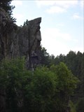
|  Chief Watching Over Us Chief Watching Over Us
in Simulacra The face in the stone is located on Rt. 44 . posted by:  sanders3 sanders3 location: South Dakota date approved: 07/21/2008 last visited: 07/28/2013 |
 view gallery view gallery E5.8 km E5.8 km
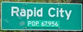
|  Rapid City, South Dakota ~ Population 67,956 Rapid City, South Dakota ~ Population 67,956
in Population Signs This Population Sign is on the west side of Jackson Blvd (South Dakota Highway 44) at Trout Court at the southeastern city limits of Rapid City, South Dakota. posted by: brwhiz location: South Dakota date approved: 12/18/2012 last visited: 06/23/2019 |
 view gallery view galleryNE6.4 km | Westberry Trails Fire in South Dakota Historical Markers Interpretive sign at a roadside pullout on a forest fire lookout describing the event with data on forest fires. posted by: plainsdrifter358 location: South Dakota date approved: 08/11/2007 last visited: 08/21/2015 |
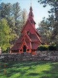 view gallery view galleryE6.9 km |  Rapid City, South Dakota: 12th Century Replica Church Rapid City, South Dakota: 12th Century Replica Church
in Roadside Attractions The Stavkirke Church is an exact replica of a 12th century Norwegian church, all intricately wooden and Nordic-looking. posted by: WalksfarTX location: South Dakota date approved: 10/30/2015 last visited: 11/10/2019 |
 view gallery view galleryE6.9 km |  Chapel in the Hills - Rapid City, SD Chapel in the Hills - Rapid City, SD
in U.S. National Register of Historic Places The Chapel in the Hills is an exact replica of the Borgund stave church in Norway. The Chapel in the Hills was dedicated on July 6, 1969. posted by: WalksfarTX location: South Dakota date approved: 11/01/2015 last visited: 11/10/2019 |
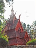 view gallery view galleryE6.9 km |  Chapel in the Hills - Rapid City, SD Chapel in the Hills - Rapid City, SD
in Exact Replicas The Chapel in the Hills is an exact replica of the Borgund stave church in Norway. The Chapel in the Hills was dedicated on July 6, 1969. posted by: WalksfarTX location: South Dakota date approved: 10/29/2015 last visited: 11/10/2019 |
 view gallery view gallery S8.4 km S8.4 km
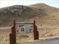
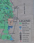
|  Black Hills National Forest Black Hills National Forest
in 'You Are Here' Maps You Are Here at a set of interpretive signs for the Black Hills National Forest on the north side of US Highway 16 southwest of Rapid City. posted by: brwhiz location: South Dakota date approved: 12/16/2012 last visited: 06/23/2019 |
 view gallery view gallery W8.5 km W8.5 km
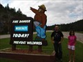
|  Pactola Reservoir Smokey Bear Pactola Reservoir Smokey Bear
in Smokey Bear Sign Sightings Smokey Bear located near the Pactola Reservoir. posted by: sanders3 location: South Dakota date approved: 07/21/2008 last visited: 08/22/2013 |
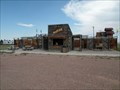 view gallery view gallerySE8.5 km |  Miner's Maze - Rapid City, South Dakota Miner's Maze - Rapid City, South Dakota
in Outdoor Mazes Outdoor maze in Rapid City, South Dakota. posted by: paulspaper location: South Dakota date approved: 07/27/2016 last visited: 09/01/2019 |
 view gallery view gallerySE8.5 km |  Putz n Glo - Rapid City, SD Putz n Glo - Rapid City, SD
in Miniature Golf Indoor blacklight mini golf near Rapid City, SD. posted by: VisN location: South Dakota date approved: 09/04/2008 last visited: 09/01/2019 |
 view gallery view galleryNW8.7 km |  Pactola Visitor Center Pactola Visitor Center
in Ranger Stations This Ranger Station is located on the west side of US Highway 385 at the southeast end of Pactola Dam, near Johnson Siding, South Dakota. This center is open from late May through September. posted by: brwhiz location: South Dakota date approved: 02/11/2013 last visited: 08/22/2013 |
 view gallery view galleryNW8.7 km | Civilian Conservation Corps Camp in South Dakota Historical Markers This South Dakota Historical Marker is located on the west side of US Highway 385 in the Pactola Visitor Center on the southeast end of Pactola Dam, near Johnson Siding, South Dakota. posted by: brwhiz location: South Dakota date approved: 02/19/2013 last visited: 08/22/2013 |
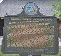 view gallery view galleryNW8.7 km |  Civilian Conservation Corps Camp F-4 Civilian Conservation Corps Camp F-4
in Civilian Conservation Corps This South Dakota Historical Marker and a stone monument are all that are left of CCC Camp F-4, now inundated by Pactola Reservoir near Johnson Siding, South Dakota posted by: brwhiz location: South Dakota date approved: 02/13/2013 last visited: never |
 view gallery view gallerySE8.7 km |  Old MacDonald's Farm Penny Smasher Old MacDonald's Farm Penny Smasher
in Penny Smashers This four-design hand-cranked Penny Smasher is in the gift shop for Old MacDonald's Farm outside Rapid City, South Dakota. No admission fee is required to access this machine. posted by: brwhiz location: South Dakota date approved: 08/25/2012 last visited: never |
 view gallery view galleryNW8.7 km | Pactola Before The Dam in South Dakota Historical Markers This Historical Marker is located on the west side of US Highway 385 in the Pactola Visitor Center on the southeast end of Pactola Dam, near Johnson Siding, South Dakota. posted by: brwhiz location: South Dakota date approved: 02/20/2013 last visited: 08/22/2013 |
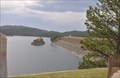 view gallery view galleryNW8.7 km |  Pactola Dam & Reservoir ~ Johnson Siding, South Dakota Pactola Dam & Reservoir ~ Johnson Siding, South Dakota
in Water Dams This Water Dam is located on the west side of US Highway 385 about 15 miles west of Rapid City, southwest of Johnson Siding, South Dakota. posted by: brwhiz location: South Dakota date approved: 02/13/2013 last visited: 08/20/2003 |
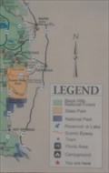 view gallery view galleryNW8.7 km | Black Hills National Forest ~ Pactola Dam in 'You Are Here' Maps You Are Here at a set of interpretive signs for the Black Hills National Forest on the west side of US Highway 385, at the Pactola Dam Visitor Center southwest of Rapid City. posted by: brwhiz location: South Dakota date approved: 12/16/2012 last visited: 07/15/2017 |
 view gallery view galleryNW8.7 km | Pactola Camp F-4 in South Dakota Historical Markers This stone monument for CCC Camp F-4, now covered by the waters of Pactola Reservoir, is located on the west side of US Highway 385 in the Pactola Visitor Center on the southeast end of Pactola Dam, near Johnson Siding, South Dakota. posted by: brwhiz location: South Dakota date approved: 02/20/2013 last visited: 08/22/2013 |
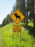
 view gallery view galleryW8.9 km |  Bighorn Sheep Crossing - Near Hill City, SD Bighorn Sheep Crossing - Near Hill City, SD
in Uncommon Crossing Signs A sign along northbound US 385 advises you to be on the lookout for bighorn sheep over the next mile. You may see some deer, too, so be careful. posted by: QuarrellaDeVil location: South Dakota date approved: 10/15/2015 last visited: never |
 view gallery view galleryW9.2 km | Bighorn Sheep Crossing - Highway 385, South Dakota in Uncommon Crossing Signs bighorn sheep crossing sign located on the highway 385 in South Dakota, USA posted by: oiseau_ca location: South Dakota date approved: 09/10/2014 last visited: 11/10/2019 |
 view gallery view galleryE9.2 km | Black Hills Maze - Rapid City, South Dakota in Outdoor Mazes This difficult year-round maze is found along highway 16, the road to Mt. Rushmore and Custer State Park. posted by: Hikenutty location: South Dakota date approved: 07/09/2007 last visited: 07/23/2014 |
 view gallery view galleryNE9.2 km |  Dairy Queen, Rapid City, South Dakota Dairy Queen, Rapid City, South Dakota
in Dairy Queen Restaurants One of several Dairy Queen restaurants in the state's second largest city. posted by: NGComets location: South Dakota date approved: 04/11/2011 last visited: 07/15/2017 |
|