 view gallery view gallery NE6.4 km NE6.4 km
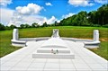
|   Afghanistan-Iraq War Memorial - Vermont Global War on Terror Memorial - Randolph, VT Afghanistan-Iraq War Memorial - Vermont Global War on Terror Memorial - Randolph, VT
in Afghanistan-Iraq War Memorials Dedicated to 40 soldiers that gave their lives in Afghanistan and Iraq. posted by:  nomadwillie nomadwillie location: Vermont date approved: 04/17/2013 last visited: 09/29/2018 |
 view gallery view gallery SE7.2 km SE7.2 km
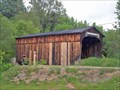
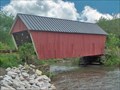
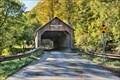
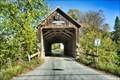
|  Kingsbury Bridge Kingsbury Bridge
in Covered Bridges This is one of several covered bridges in the local area - A good day's outing. posted by:  CoveredBridgeGuy CoveredBridgeGuy location: Vermont date approved: 01/02/2007 last visited: never |
 view gallery view gallery E7.9 km E7.9 km
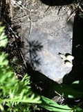
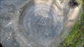
|  A00033 A00033
in U.S. Benchmarks A State of Vermont Highway Department benchmark located southeast of the intersection of VT Rt 14 and Dugout Road. posted by: Jay-7 location: Vermont date approved: 06/21/2013 last visited: never |
 view gallery view gallery N8.7 km N8.7 km
|  Rest Area I-89 South - Randolph, VT Rest Area I-89 South - Randolph, VT
in Highway Rest Areas This rest area on I-89 South in Randolph, Vermont, is open only 7:00 a.m. to 9:00 p.m. posted by: silverquill location: Vermont date approved: 12/10/2007 last visited: 08/21/2014 |
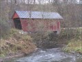
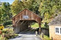
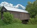
 view gallery view galleryE8.7 km | Gifford Bridge in Covered Bridges This bridge has a rather unique truss structure - possibly once an uncovered bridge with a multiple king post truss - Later added a roof and another multiple king post truss above the other one. posted by: CoveredBridgeGuy location: Vermont date approved: 12/23/2006 last visited: 06/12/2015 |
 view gallery view galleryE8.9 km | Braley Bridge in Covered Bridges Unusual truss - Large multiple king post over small multiple king post posted by: CoveredBridgeGuy location: Vermont date approved: 12/14/2006 last visited: 06/12/2015 |
 view gallery view galleryN10.1 km | Rest Area I-89 North - Randolph, VT in Highway Rest Areas This rest area on I-89 N in Randolph, Vermont, features some nice displays, but is open only 7:00 a.m. to 9:00 p.m. posted by: silverquill location: Vermont date approved: 12/10/2007 last visited: 12/28/2020 |
 view gallery view gallerySE11.9 km | DL8595: SILK (VTDH/NGS, Royalton, VT) in U.S. Benchmarks A VTHD standard bench mark disk, located in Royalton, VT.
The NGS PID# is DL8595. posted by: NH2beers location: Vermont date approved: 10/11/2011 last visited: 06/19/2013 |
 view gallery view gallerySE13 km | OD0287: 504 (USGS/NGS, Royalton, VT) in U.S. Benchmarks A USGS standard bench mark disk, located in Royalton, VT.
The NGS PID# is OD0287. posted by: NH2beers location: Vermont date approved: 10/11/2011 last visited: never |
 view gallery view galleryE13 km |  Cilley Covered Bridge - Tunbridge VT Cilley Covered Bridge - Tunbridge VT
in U.S. National Register of Historic Places The Cilley Covered Bridge, built in 1883, it is a fine example of a Kingspost truss structure, and is one of the town's five 19th-century covered bridges posted by: nomadwillie location: Vermont date approved: 10/04/2019 last visited: never |
 view gallery view galleryE13.2 km | Cilley Bridge in Covered Bridges There are 8 nice bridges within 6 miles of this one posted by: CoveredBridgeGuy location: Vermont date approved: 12/19/2006 last visited: never |
 view gallery view gallerySE13.4 km | DL8555: A00028 (VTDH/NGS, Royalton, VT) in U.S. Benchmarks A VTDH standard survey disk, located in Royalton, VT.
The NGS PID# is DL8555. posted by: NH2beers location: Vermont date approved: 10/11/2011 last visited: never |
 view gallery view galleryE13.8 km | Mill Covered Bridge - Tunbridge VT in U.S. National Register of Historic Places The Mill Covered Bridge, was built in 2000, nearly replicating a previous structure built on the site in 1883 and lost due to ice damage. It is one of a high concentration of covered bridges in Tunbridge and Chelsea. posted by: nomadwillie location: Vermont date approved: 10/04/2019 last visited: never |
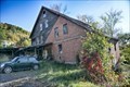 view gallery view galleryE13.8 km | Hayward and Kibby Mill - Tunbridge VT in U.S. National Register of Historic Places The Hayward and Kibby Mill, also known as the Tunbridge Mill, includes a substantially complete water-powered 19th-century grist mill dating back to 1820, with a later sawmill added about 1870. posted by: nomadwillie location: Vermont date approved: 10/04/2019 last visited: never |
 view gallery view galleryE14 km | Howe Covered Bridge - Tunbridge VT in U.S. National Register of Historic Places The Howe Covered Bridge was built in 1879, it is one of five surviving bridges in the town. posted by: nomadwillie location: Vermont date approved: 10/04/2019 last visited: never |
 view gallery view galleryE14 km | Howe Bridge in Covered Bridges This is a nicely maintained bridge connecting the Howe farm to the highway VT-110 posted by: CoveredBridgeGuy location: Vermont date approved: 01/02/2007 last visited: never |
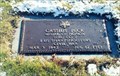 view gallery view galleryN14 km |  Cassius Peck-Brookfield, VT Cassius Peck-Brookfield, VT
in Medal Of Honor Resting Places Civil War Medal of Honor Recipient for action near Blackburn’s Ford, VA on September 19, 1862. He is buried in Brookfield Cemetery, Brookfield, VT in Section 2, Lot 7. posted by: Don.Morfe location: Vermont date approved: 03/14/2019 last visited: 12/06/2021 |
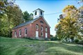 view gallery view gallerySE14.2 km | South Tunbridge Methodist Episcopal Church - Tunbridge, VT in U.S. National Register of Historic Places The South Tunbridge Methodist Episcopal Church, Built in 1833, it is one of the finest examples of late Federal period architecture in Orange County, and was a mainstay of social and civic life in southern Tunbridge for many years. posted by: nomadwillie location: Vermont date approved: 10/04/2019 last visited: never |
 view gallery view gallerySE14.6 km | Royalton Mill Complex - South Royalton VT in U.S. National Register of Historic Places The Royalton Mill Complex is a three-building residential site in what is now a rural setting of Royalton, Vermont. posted by: nomadwillie location: Vermont date approved: 10/04/2019 last visited: never |
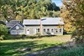
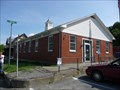 view gallery view gallerySE15.1 km |  South Royalton, VT 05068 South Royalton, VT 05068
in U.S. Post Offices Located at 239 Chelsea Street South Royalton VT posted by: nomadwillie location: Vermont date approved: 05/17/2011 last visited: 06/25/2010 |
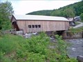 view gallery view galleryE15.1 km | Mill Bridge in Covered Bridges This is covered bridge territory - 7, all within a few miles of each other. Take a picnic lunch posted by: CoveredBridgeGuy location: Vermont date approved: 01/04/2007 last visited: 04/14/2008 |
 view gallery view galleryN15.4 km |  Floating Bridge - Brookfield, VT Floating Bridge - Brookfield, VT
in Roadside Attractions The present floating bridge, built in 2015, replaced the previous version that was closed in 2008. posted by: NorStar location: Vermont date approved: 09/17/2018 last visited: 09/30/2018 |
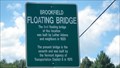
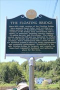 view gallery view galleryN15.4 km |  The Floating Bridge - Brookfield, VT The Floating Bridge - Brookfield, VT
in Vermont Historical Markers Since 1820, eight versions of the Floating Bridge have spanned Sunset Lake. posted by: NorStar location: Vermont date approved: 11/16/2018 last visited: 09/30/2018 |
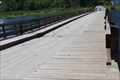 view gallery view galleryN15.4 km |  The Floating Bridge - Brookfield, VT The Floating Bridge - Brookfield, VT
in Plank Roads The floating bridge over Vermont has wood planks and railings for cars to drive on over Sunset Lake. posted by: NorStar location: Vermont date approved: 09/12/2018 last visited: 09/30/2018 |
 view gallery view galleryN15.4 km |  Unique Floating Bridge - Brookfield, Vermont Unique Floating Bridge - Brookfield, Vermont
in Orphaned Bridges Unique Floating Bridge is located in Brookfield, Vermont. posted by: tatie location: Vermont date approved: 09/05/2012 last visited: 06/07/2023 |
|