 view gallery view gallery NE6.1 km NE6.1 km
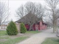
|   John T. Patterson-Mauston, WI John T. Patterson-Mauston, WI
in Medal Of Honor Resting Places Civil War Medal of Honor Recipient for action at Winchester, VA on June 14, 1863. He is buried in Mauston Cemetery, Mauston, WI in Section 2, Block 44. posted by:  Don.Morfe Don.Morfe location: Wisconsin date approved: 03/14/2019 last visited: 12/06/2021 |
 view gallery view galleryNE7.9 km |  Welcome to Mauston - Wisconsin Welcome to Mauston - Wisconsin
in Welcome Signs This welcome sign is on Hwy 82 E. As you enter town you will see the sign - The City Of Mauston - What's Shakin' posted by:  DougandSandra DougandSandra location: Wisconsin date approved: 07/23/2012 last visited: never |
 view gallery view galleryNE8.4 km |  Kwik Trip Travel Center - I-94 WB, Mauston, WI Kwik Trip Travel Center - I-94 WB, Mauston, WI
in Truck Stops Located at mile marker #69 Interstate 94 west at 611 State Rd. 82 Mauston, WI posted by: DougandSandra location: Wisconsin date approved: 03/31/2012 last visited: never |
 view gallery view galleryNE8.4 km |  Transport Truck and Trailer - Mauston, WI Transport Truck and Trailer - Mauston, WI
in Elevated Everyday Objects Located at mile marker #69 Interstate 94 west at 611 State Rd. 82 Mauston, WI posted by: DougandSandra location: Wisconsin date approved: 03/31/2012 last visited: 11/26/2016 |
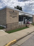 view gallery view gallery W10.3 km W10.3 km
|  Elroy, Wisconsin 53979 Elroy, Wisconsin 53979
in U.S. Post Offices Small town post office. Elevation 976 feet. posted by: NGComets location: Wisconsin date approved: 05/29/2023 last visited: never |
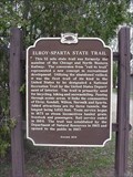 view gallery view galleryW10.8 km |  Elroy-Sparta State Trail Elroy-Sparta State Trail
in Wisconsin Historical Markers Elroy-Sparta State Trail Historical Marker at rest area on Hwy 71 on the west edge of Elroy posted by: onfire4jesus location: Wisconsin date approved: 04/23/2007 last visited: 10/20/2013 |
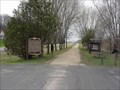 view gallery view galleryW10.8 km |  Elroy-Sparta Trail Elroy Trailhead Elroy-Sparta Trail Elroy Trailhead
in Rails to Trails The Elroy-Sparta Trail was the first trail of its kind in the United States to be designated a National Recreational Trail by the United States Department of Interior. Elroy is one end of the trail. posted by: onfire4jesus location: Wisconsin date approved: 08/20/2007 last visited: 10/03/2014 |
![Image for [Legacy] A&W - New Lisbon, Wisconsin](https://img.geocaching.com/waymarking/log/small/dbbdab4c-306c-41ae-af2e-9a7104560e23.jpg) view gallery view gallery N14 km N14 km
|  [Legacy] A&W - New Lisbon, Wisconsin [Legacy] A&W - New Lisbon, Wisconsin
in A + W Restaurants This restaurant is inside a truck stop, attached to a Subway, Piccadilly Circus pizza, and gas station. It's located off exit 61 of the interstate highway. posted by: SageInThyme82 location: Wisconsin date approved: 07/27/2015 last visited: 08/13/2022 |
 view gallery view gallery E14.5 km E14.5 km
| Iron Brigade Historical Marker in Wisconsin Historical Markers The Iron Brigade Historical Marker posted by: onfire4jesus location: Wisconsin date approved: 03/17/2007 last visited: 08/19/2018 |
 view gallery view galleryE14.5 km | Wisconsin River Historical Marker in Wisconsin Historical Markers The Wisconsin River "The Nation's Hardest-Working River" Historical Marker posted by: onfire4jesus location: Wisconsin date approved: 03/17/2007 last visited: 08/19/2018 |
 view gallery view galleryE15.9 km | Sand Counties Historical Marker in Wisconsin Historical Markers The Sand Counties - Aldo Leopold Territory Historical Marker posted by: onfire4jesus location: Wisconsin date approved: 03/17/2007 last visited: 07/26/2021 |
 view gallery view galleryW18.2 km | Elroy-Sparta State Trail in Wisconsin Historical Markers Elroy-Sparta State Trail Historical Marker at the Kendall Depot, N Railroad St, Hwy 71, Kendall posted by: onfire4jesus location: Wisconsin date approved: 04/23/2007 last visited: 11/10/2012 |
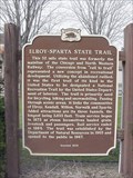 view gallery view galleryW18.2 km |  FIRST - Rail to trail designated Nat. Recreational Trail FIRST - Rail to trail designated Nat. Recreational Trail
in First of its Kind The Elroy-Sparta rail-to-trail was the first trail of its kind in the United States to be designated a National Recreational Trail by the United States Department of Interior. The headquarters for the trail is here in Kendall, WI. posted by: onfire4jesus location: Wisconsin date approved: 08/17/2007 last visited: 04/23/2007 |
 view gallery view galleryW18.2 km | Elroy-Sparta Trail Kendall Trailhead in Rails to Trails The Elroy-Sparta Trail was the first trail of its kind in the United States to be designated a National Recreational Trail by the United States Department of Interior. Here in Kendall, there is a place to park your car while you use the trail. posted by: onfire4jesus location: Wisconsin date approved: 08/20/2007 last visited: 04/23/2007 |
 view gallery view galleryNE18.5 km |  DH5691 - GER DH5691 - GER
in U.S. Benchmarks A disk along Juneau County highway G near Castle Rock Lake. posted by: Shorelander location: Wisconsin date approved: 07/03/2006 last visited: 07/02/2006 |
 view gallery view gallery NW20.1 km NW20.1 km
| Castle Rock in Wisconsin Historical Markers Castle Rock Historical Marker in Wayside on Hwy C 1/2 mile east of Camp Douglas posted by: onfire4jesus location: Wisconsin date approved: 04/23/2007 last visited: 08/08/2018 |
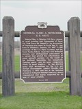 view gallery view gallery SW20.4 km SW20.4 km
| Admiral Marc A. Mitscher, U. S. Navy in Wisconsin Historical Markers Admiral Marc A. Mitscher, U. S. Navy Historical Marker in wayside on Hwy 33 just west of Hillsboro posted by: onfire4jesus location: Wisconsin date approved: 04/24/2007 last visited: 08/26/2007 |
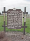 view gallery view gallerySW20.4 km | African American Settlers of Cheyenne Valley in Wisconsin Historical Markers African American Settlers of Cheyenne Valley Historical Marker in the Cheyenne Settlers Historic Parknear 300 Water Ave. in Hillsboro posted by: onfire4jesus location: Wisconsin date approved: 04/23/2007 last visited: 06/05/2019 |
 view gallery view galleryNW20.6 km | Wisconsin Military Reservation in Wisconsin Historical Markers Wisconsin Military Reservation Historical Marker just inside main gate to Camp Williams and Volk Field near the town of Camp Douglas posted by: onfire4jesus location: Wisconsin date approved: 04/23/2007 last visited: 09/20/2011 |
 view gallery view galleryNW20.6 km | FIRST - Wisconsin fighter pilot killed in action during the Korean Conflict. in First of its Kind Lt. Jerome A. Volk was killed on February 28, 1951 in the Korean conflict and became the first Wisconsin fighter pilot killed in action during the Korean conflict. posted by: onfire4jesus location: Wisconsin date approved: 08/10/2007 last visited: 09/20/2011 |
 view gallery view galleryE20.6 km | Hop Raising Historical Marker in Wisconsin Historical Markers Hop Raising Historical Marker posted by: onfire4jesus location: Wisconsin date approved: 03/18/2007 last visited: 08/19/2007 |
 view gallery view galleryN21.1 km | TT 21 E in U.S. Benchmarks USGS benchmark at the Lone Rock School, northeast of Camp Douglas, Wisconsin. posted by: msrubble location: Wisconsin date approved: 07/13/2014 last visited: never |
 view gallery view galleryNE22.5 km | DH5480 - GERMANTOWN W GPS in U.S. Benchmarks A GPS station on Buckhorn Bridge in Central Wisconsin. posted by: Shorelander location: Wisconsin date approved: 07/03/2006 last visited: 07/02/2006 |
 view gallery view galleryNW24.1 km | Mesas and Buttes in Wisconsin Historical Markers Mesas and Buttes Historical Marker in Mill Bluff State Park off Hwy 12 4 miles west of Camp Douglas posted by: onfire4jesus location: Wisconsin date approved: 04/23/2007 last visited: 02/25/2010 |
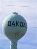 view gallery view galleryNW29 km |  Oakdale Water Tower - Oakdale, WI Oakdale Water Tower - Oakdale, WI
in Water Towers This is the tower that suplies the water to Oakdale, WI and surrounding area. posted by: REUAHNESIE location: Wisconsin date approved: 10/23/2012 last visited: never |
|