 view gallery view gallery E39.1 km E39.1 km
|   T42N R84W S21 S28 1/4 - Johnson County, Wyoming T42N R84W S21 S28 1/4 - Johnson County, Wyoming
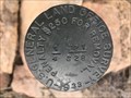
in Public Land Survey Marks This 1933 GLO quarter corner marker is located on top of a thin limestone ridge situated between two draws near the Outlaw Cave campground. posted by:  Tom.dog Tom.dog location: Wyoming date approved: 05/02/2023 last visited: never |
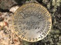 view gallery view galleryE39.9 km | T42N R84W S21 S22 S27 S28 - Johnson County, Wyoming in Public Land Survey Marks A 1933 GLO section corner marker on South River Slope in the Hole-In-The-Wall region of southwestern Johnson County. posted by: Tom.dog location: Wyoming date approved: 05/02/2023 last visited: never |
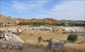
 view gallery view gallery SW41.8 km SW41.8 km
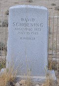
|  David Schoening David Schoening
in Out of Place Graves This Out of Place Grave sits alone in the middle of nowhere on the north side of Badwater Road just east of Lysite, Wyoming. posted by: brwhiz location: Wyoming date approved: 08/26/2013 last visited: never |
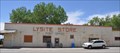 view gallery view gallerySW42.3 km |  Lysite, Wyoming 82642 Lysite, Wyoming 82642
in U.S. Post Offices This Post Office is located at 25 Fremont Street in Lysite, Wyoming. posted by: brwhiz location: Wyoming date approved: 07/02/2013 last visited: never |
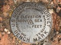 view gallery view galleryE42.6 km |  54 BE - Johnson County, Wyoming 54 BE - Johnson County, Wyoming
in U.S. Benchmarks This U.S. Geological Survey Benchmark can be found to the southeast of Barnum, near the end of State Highway 190 at the split of Barnum Road and Barnum Mountain Road. posted by: Tom.dog location: Wyoming date approved: 05/02/2023 last visited: never |
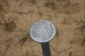
 view gallery view gallery N44.6 km N44.6 km
| Warner 1 in U.S. Benchmarks BLM Project marker for Warner Reservoir south of Ten Sleep WY posted by: Wyobulldog location: Wyoming date approved: 07/01/2008 last visited: never |
 view gallery view gallery NW45.1 km NW45.1 km
| Z. D. Res. in U.S. Benchmarks BLM Project Marker posted by: Wyobulldog location: Wyoming date approved: 06/12/2008 last visited: never |
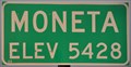
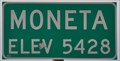 view gallery view gallerySW53.9 km |  Moneta, Wyoming ~ Elevation 5428 Feet Moneta, Wyoming ~ Elevation 5428 Feet
in Elevation Signs This Elevation Sign is at the eastern town limits of Moneta, Wyoming on US Highway 20&26. posted by: brwhiz location: Wyoming date approved: 07/25/2013 last visited: never |
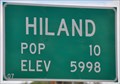 view gallery view gallery S54.1 km S54.1 km
| Hiland, Wyoming ~ Elevation 5998 Feet in Elevation Signs This combination Elevation/Population sign is on the northeast side of US Highway 20&26 at the eastern town limits of Hiland, Wyoming. posted by: brwhiz location: Wyoming date approved: 07/25/2013 last visited: never |
 view gallery view galleryS54.1 km |  Hiland, Wyoming ~ Population 10 Hiland, Wyoming ~ Population 10
in Population Signs This combination Elevation/Population sign is on the northeast side of US Highway 20&26 at the eastern town limits of Hiland, Wyoming. posted by: brwhiz location: Wyoming date approved: 07/25/2013 last visited: never |
 view gallery view gallerySW54.1 km | Moneta, Wyoming ~ Elevation 5428 in Elevation Signs This Elevation Sign is at the western town limits of Moneta, Wyoming on US Highway 20&26. posted by: brwhiz location: Wyoming date approved: 09/24/2012 last visited: never |
 view gallery view galleryS58.1 km | VS 6 Waltman-Arminto Rd. Wyoming in U.S. Benchmarks Standard USGS disc mounted in the top of a square pillar posted by: High-Plains-Drifter location: Wyoming date approved: 05/03/2010 last visited: never |
 view gallery view galleryS59.9 km |  Waltman Rest Area ~ US Highway 20/26 Waltman Rest Area ~ US Highway 20/26
in 'You Are Here' Maps You Are Here at the Waltman Rest Area on US Highway 20/26 between Hiland and Waltman, Wyoming. posted by: brwhiz location: Wyoming date approved: 09/24/2012 last visited: 05/26/2007 |
 view gallery view galleryS59.9 km |  Mama Sage - Waltman Rest Area, Wyoming Mama Sage - Waltman Rest Area, Wyoming
in Flora and Fauna Information Signs This Wyoming's Wildlife sign at the Waltman Rest Area describes the role of sage in supporting Wyoming's animal life. posted by: Tom.dog location: Wyoming date approved: 02/06/2024 last visited: never |
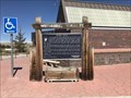
 view gallery view galleryS59.9 km |  Bridger Road ~ Waltman Crossing - Waltman Rest Area, Wyoming Bridger Road ~ Waltman Crossing - Waltman Rest Area, Wyoming
in Wyoming Historical Markers This sign gives a glimpse of the history of the Bridger Road, a largely forgotten route that connected the Oregon Trail with the Montana goldfields in the 1860s. posted by: Tom.dog location: Wyoming date approved: 02/02/2024 last visited: never |
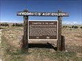 view gallery view galleryS59.9 km | "Committed to the Land" - Waltman Rest Area, Wyoming in Wyoming Historical Markers This Wyoming's Agriculture sign tells of the difficult circumstances faced by homesteaders and ranchers in the Wind River Basin region during the time of its settlement. posted by: Tom.dog location: Wyoming date approved: 02/02/2024 last visited: never |
 view gallery view gallerySW61.2 km | DS 5 USGS Badwater Rd. near Bonneville/Lysite, WY in U.S. Benchmarks Standard USGS disc mounted in the top of a square pillar about 18" high. posted by: High-Plains-Drifter location: Wyoming date approved: 05/03/2010 last visited: never |
 view gallery view galleryE61.5 km | Sta. 95+62.8 El. 4743.10 - Johnson County, Wyoming in U.S. Benchmarks A State Highway Department R.O.W. marker on the northwest side of State Highway 190 to the southwest of the town of Kaycee. posted by: Tom.dog location: Wyoming date approved: 05/02/2023 last visited: never |
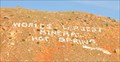 view gallery view gallery W62 km W62 km
|  Worlds Largest Mineral Hot Spring Worlds Largest Mineral Hot Spring
in Letters on Hills These words on the hillside appear above the hot springs in Thermopolis, Wyoming. posted by: brwhiz location: Wyoming date approved: 09/24/2012 last visited: 08/08/2008 |
 view gallery view galleryW62.1 km |  LARGEST -- Mineral Hot Spring in the World LARGEST -- Mineral Hot Spring in the World
in Superlatives The words "Worlds Largest Mineral Hot Spring" appear on the hillside appear above the hot spring in Thermopolis, Wyoming. posted by: brwhiz location: Wyoming date approved: 09/28/2012 last visited: 08/08/2008 |
 view gallery view galleryW62.1 km |  Worlds Largest Mineral Hot Spring ~ Thermopolis, Wyoming Worlds Largest Mineral Hot Spring ~ Thermopolis, Wyoming
in Hot Springs The words "Worlds Largest Mineral Hot Spring" appear on the hillside above the hot spring in Thermopolis, Wyoming. posted by: brwhiz location: Wyoming date approved: 09/24/2012 last visited: 06/05/2017 |
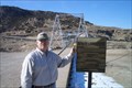 view gallery view galleryW62.1 km |  Thermopolis Suspension Bridge Thermopolis Suspension Bridge
in Pedestrian Suspension Bridges Enjoy the swinging as you cross the bridge. posted by: MtnPirates location: Wyoming date approved: 03/09/2006 last visited: 06/05/2017 |
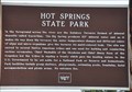 view gallery view galleryW62.4 km | Hot Springs State Park in Wyoming Historical Markers This Wyoming Historical Marker is located on the east side of US Highway 20 on the northern edge of Thermopolis, Wyoming overlooking the hot springs of Hot Springs State Park. posted by: brwhiz location: Wyoming date approved: 09/25/2012 last visited: 06/05/2017 |
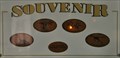 view gallery view galleryW62.4 km |  Wyoming Dinosaur Center Penny Smasher Wyoming Dinosaur Center Penny Smasher
in Penny Smashers This four-design Penny Smasher is in the Wyoming Dinosaur Center at 110 Carter Ranch Road in Thermopolis, Wyoming. posted by: brwhiz location: Wyoming date approved: 10/22/2011 last visited: never |
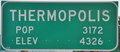 view gallery view galleryW62.4 km | Thermopolis, Wyoming ~ Population 3172 in Population Signs This combination Elevation/Population sign is at the northern city limits of Thermopolis, Wyoming on US Highway 20. posted by: brwhiz location: Wyoming date approved: 09/25/2012 last visited: never |
|