 view gallery view gallery SE21.4 km SE21.4 km
|   Hills Hills
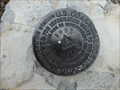
in U.S. Benchmarks HILLS PEAK posted by:  Dustydew Dustydew location: Oregon date approved: 11/22/2014 last visited: never |
 view gallery view gallery N23.7 km N23.7 km
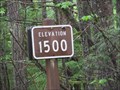
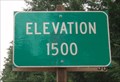
|  Hills Creek Dam (West Side) - Oakridge, OR - 1500' Hills Creek Dam (West Side) - Oakridge, OR - 1500'
in Elevation Signs The 1500' contour is marked along FS Road 21 near the west end of Hills Creek Dam. posted by: WR7X location: Oregon date approved: 05/18/2014 last visited: never |
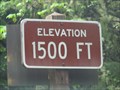 view gallery view galleryN24 km | Hills Creek Dam (East Side) - Oakridge, OR - 1500' in Elevation Signs The 1500' contour is marked along FS Road 23 near the east end of Hills Creek Dam. posted by: WR7X location: Oregon date approved: 05/18/2014 last visited: never |
 view gallery view gallery NE24 km NE24 km
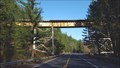
|  Salt Creek Trestle Bridge - Lane County, OR Salt Creek Trestle Bridge - Lane County, OR
in Railroad Bridges Spanning Hwy 58, this railroad trestle bridge is operated by Union Pacific Railroad. posted by: NW_history_buff location: Oregon date approved: 07/06/2018 last visited: never |
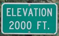 view gallery view galleryNE25.6 km | Willamette Highway ~ Elevation 2000 Feet in Elevation Signs This Elevation Sign is located on the northeast side of Oregon Highway 58 (Willamette Highway) about 9.6 miles southeast of Oakridge, Oregon. posted by: brwhiz location: Oregon date approved: 05/05/2013 last visited: 05/09/2014 |
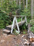
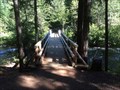
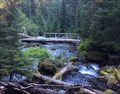 view gallery view galleryNE25.6 km |  Diamond Creek Bridge - Oregon Diamond Creek Bridge - Oregon
in Hiking Path Footbridges Footbridge across Diamond Creek near Diamond Creek Falls. posted by: Volcanoguy location: Oregon date approved: 12/15/2014 last visited: 09/06/2014 |
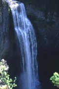
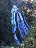 view gallery view galleryNE25.6 km |  Diamond Creek Falls - Willamette National Forest, Oregon Diamond Creek Falls - Willamette National Forest, Oregon
in Waterfalls Diamond Creek Falls on Diamond Creek about 19 miles ESE of Oakridge, Oregon. posted by: Volcanoguy location: Oregon date approved: 12/15/2014 last visited: 09/06/2014 |
 view gallery view gallery S25.9 km S25.9 km
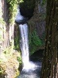
| Toketee Falls, Oregon in Waterfalls The spectacular Toketee Falls on North Umpqua River. posted by: Volcanoguy location: Oregon date approved: 12/13/2005 last visited: 05/06/2023 |
 view gallery view galleryNE26.2 km | Diamond Creek Falls Trail Bridge - Oregon in Hiking Path Footbridges Footbridge along the Diamond Creek Falls Trail. posted by: Volcanoguy location: Oregon date approved: 12/15/2014 last visited: 09/06/2014 |
 view gallery view gallery E26.6 km E26.6 km
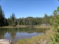
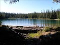
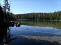
|  Lils Lake - Oregon Lils Lake - Oregon
in Natural Lakes Lils Lake in Diamond Peak Wilderness Area. posted by: Volcanoguy location: Oregon date approved: 10/13/2013 last visited: 09/07/2013 |
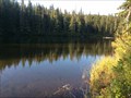
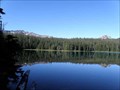 view gallery view galleryE26.6 km | Yoran Lake - Oregon in Natural Lakes Yoran Lake in Diamond Peak Wilderness Area. posted by: Volcanoguy location: Oregon date approved: 10/13/2013 last visited: 09/07/2013 |
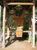
 view gallery view galleryN26.7 km |  James Tharp Memorial Bridge. Oakridge, Oregon James Tharp Memorial Bridge. Oakridge, Oregon
in People-Named Places From the Plaque on the bridge: "James Tharp Memorial Bridge
in memory of James Tharp, Park Director/Police Chief. Installed 09-93. City of Oakridge, USDA Forest Service." posted by: Queens Blessing location: Oregon date approved: 08/26/2009 last visited: 09/02/2013 |
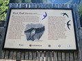
 view gallery view galleryN26.7 km |  The Lost Wagon Train-The Elliott Expedition Cutoff, Oregon The Lost Wagon Train-The Elliott Expedition Cutoff, Oregon
in Wagon Roads and Trails The Lost Wagon Train tale is a well known story in Oakridge, Oregon. posted by: Queens Blessing location: Oregon date approved: 08/23/2009 last visited: 09/15/2012 |
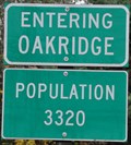 view gallery view galleryN26.7 km |  Oakridge, Oregon ~ Population 3320 Oakridge, Oregon ~ Population 3320
in Population Signs This Population Sign is on the northeast side of Oregon Highway 58 (Willamette Highway) at the southeastern town limits of Oakridge, Oregon. posted by: brwhiz location: Oregon date approved: 02/20/2013 last visited: never |
 view gallery view galleryE26.7 km | Karen Lake - Oregon in Natural Lakes Karen Lake in Diamond Peak Wilderness Area. posted by: Volcanoguy location: Oregon date approved: 10/13/2013 last visited: 09/07/2013 |
 view gallery view galleryNE26.7 km | Too Much Bear Lake - Oregon in Natural Lakes Too Much Bear Lake is located near Salt Creek Falls. posted by: Volcanoguy location: Oregon date approved: 12/16/2014 last visited: 09/06/2014 |
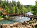
 view gallery view galleryNE26.9 km | Salt Creek Bridge - Oregon in Hiking Path Footbridges Footbridge across Salt Creek near start of the Diamond Creek Falls Trail. posted by: Volcanoguy location: Oregon date approved: 12/15/2014 last visited: 09/06/2014 |
 view gallery view galleryNE27 km | Salt Creek Falls, Oregon in Waterfalls The spectacular Salt Creek Falls on Salt Creek. posted by: Volcanoguy location: Oregon date approved: 12/14/2005 last visited: 09/07/2009 |
 view gallery view galleryN27 km |  Greenwater Park Rest Area - Oakridge, OR Greenwater Park Rest Area - Oakridge, OR
in Highway Rest Areas A park and rest area on the east end of Oakridge. posted by: NW_history_buff location: Oregon date approved: 04/23/2018 last visited: never |
 view gallery view galleryNE27 km |  Salt Creek Falls, Oakridge, OR, USA Salt Creek Falls, Oakridge, OR, USA
in Birdwatching Locations Salt Creek Falls, near Oakridge, is one of the few places Black Swifts (Cypseloides niger) can be found in Oregon. posted by: Queens Blessing location: Oregon date approved: 08/23/2009 last visited: 09/16/2012 |
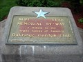 view gallery view galleryN27 km |  Green Waters Park - Highway 58, Oakridge, Oregon Green Waters Park - Highway 58, Oakridge, Oregon
in Blue Star Memorial Highway Markers A Blue Star memorial located in a rest area and park just off of Highway 58 in Oakridge, Oregon. posted by: TheBeanTeam location: Oregon date approved: 12/08/2010 last visited: 04/22/2018 |
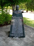 view gallery view galleryN27 km |  Maximo Yabes, Medal of Honor Recipient, Oregon Maximo Yabes, Medal of Honor Recipient, Oregon
in Specific Veteran Memorials Maximo Yabes received the Medal of Honor. posted by: Queens Blessing location: Oregon date approved: 08/24/2009 last visited: 04/22/2018 |
 view gallery view galleryE27.2 km | Hidden Lake - Oregon in Natural Lakes Hidden Lake in Diamond Peak Wilderness Area. posted by: Volcanoguy location: Oregon date approved: 10/13/2013 last visited: 09/07/2013 |
 view gallery view galleryN27.7 km |  LOOM Lodge 2191 - Oakridge, OR LOOM Lodge 2191 - Oakridge, OR
in Moose Lodges and Centers This lodge is located right along Hwy 58 (Willamette Hwy). posted by: NW_history_buff location: Oregon date approved: 12/17/2014 last visited: never |
 view gallery view gallery SW28 km SW28 km
| 1500 Feet, Hwy 138 - Douglas County, OR in Elevation Signs This is the 1,500 foot mark on Hwy. 138 as it ascends along the Umpqua River in Douglas County, Oregon, towards Diamond Lake. The views of the river are spectacular, and there are numerous trails into the forest and to waterfalls. posted by:  silverquill silverquill location: Oregon date approved: 05/28/2009 last visited: never |
|