 view gallery view gallery S18 km S18 km
|   Falls Creek Falls Trail - Oregon Falls Creek Falls Trail - Oregon
in Hiking and walking trailheads This is a moderate trail leading to a beautiful waterfall, about one mile up. There is a gravel parking area on Hwy. 138, and the trail head begins with a wooden bridge across Fall Creek. (Not to be confused with Fall Creek Trail elsewhere). posted by:  silverquill silverquill location: Oregon date approved: 05/29/2009 last visited: never |
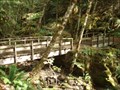
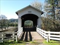
 view gallery view galleryS18 km |  Falls Creek Falls Trail Bridge - Oregon Falls Creek Falls Trail Bridge - Oregon
in Hiking Path Footbridges This wooden bridge begins the trail to a beautiful waterfall, about one mile up. There is a gravel parking area on Hwy. 138. (Not to be confused with Fall Creek Trail elsewhere in the state). The bridge is in two parts as it spans a small island. posted by: silverquill location: Oregon date approved: 05/28/2009 last visited: never |
 view gallery view gallery SW22 km SW22 km
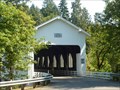
|  Tioga Bridge oustide of Glide OR Tioga Bridge oustide of Glide OR
in Arch Bridges Tioga Bridge oustide of Glide OR posted by:  kJfishman kJfishman location: Oregon date approved: 10/08/2018 last visited: never |
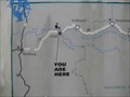
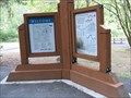 view gallery view gallerySW22.7 km |  Baker Park, Umatilla River, Oregon - Two You Are Here Maps Baker Park, Umatilla River, Oregon - Two You Are Here Maps
in 'You Are Here' Maps There are TWO "You Are Here" maps on the side-by-side information display signs at Baker Park! posted by: Queens Blessing location: Oregon date approved: 07/23/2009 last visited: 09/02/2013 |
 view gallery view gallerySW22.9 km |  Dogwood Motel Dogwood Motel
in Neon Signs The Dogwood Motel features a vintage neon sign. posted by: TheBeanTeam location: Oregon date approved: 10/14/2009 last visited: 10/08/2018 |
 view gallery view gallery SE23.7 km SE23.7 km
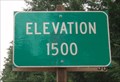
|  1500 Feet, Hwy 138 - Douglas County, OR 1500 Feet, Hwy 138 - Douglas County, OR
in Elevation Signs This is the 1,500 foot mark on Hwy. 138 as it ascends along the Umpqua River in Douglas County, Oregon, towards Diamond Lake. The views of the river are spectacular, and there are numerous trails into the forest and to waterfalls. posted by: silverquill location: Oregon date approved: 05/28/2009 last visited: never |
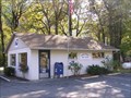 view gallery view gallerySW24.5 km |  Idleyld Park, OR, 97447 Idleyld Park, OR, 97447
in U.S. Post Offices The Idleyld Park, OR Post Office. posted by: Volcanoguy location: Oregon date approved: 11/04/2006 last visited: 11/04/2006 |
 view gallery view gallerySW29.5 km |  Veterans Memorial - Glide, OR Veterans Memorial - Glide, OR
in Non-Specific Veteran Memorials This simple memorial commemorates the 20th century veterans of Douglas County, Oregon. There is also a special plaque honoring "Rosie the Riveter" the "women of America who sacrificed . . ." Located at a wayside on Rt. 128 east of Roseburg, Oregon. posted by: silverquill location: Oregon date approved: 05/29/2009 last visited: never |
 view gallery view gallerySW29.5 km |  Hwy. 138 - Glide, OR Hwy. 138 - Glide, OR
in Blue Star Memorial Highway Markers This Blue Star Memorial Highway Marker is located beside a veteran memorial at a small wayside on Highway 138 east of Glide and the city of Roseburg, Oregon. posted by: silverquill location: Oregon date approved: 05/28/2009 last visited: never |
 view gallery view gallery N30.4 km N30.4 km
|  Dorena Bridge, OR Dorena Bridge, OR
in Covered Bridges One of many covered bridges near Cottage Grove, Oregon posted by: gypsie2 location: Oregon date approved: 03/16/2015 last visited: never |
 view gallery view gallerySW30.6 km | Glide, OR, 97443 in U.S. Post Offices The Glide, OR Post Office. posted by: Volcanoguy location: Oregon date approved: 11/03/2006 last visited: 11/04/2006 |
 view gallery view gallerySW31.4 km |  Glide Rural Fire Dept. Dist. Ten Glide Rural Fire Dept. Dist. Ten
in Firehouses This rural fire station is locate on Route 138 east of Rosburg, serving the community of Glide, and the forested area around it. posted by: silverquill location: Oregon date approved: 05/28/2009 last visited: 08/27/2003 |
 view gallery view gallerySW31.4 km | Little River (Cavitt Creek) Covered Bridge, near Glide, Oregon in Covered Bridges Little River (Cavitt Creek) Covered Bridge is east of Roseburg on Highway 138. Just before entering Glide turn south on Little River Road. The covered bridge is approximately seven miles south of Highway 138. posted by: Rose Red location: Oregon date approved: 02/14/2012 last visited: never |
 view gallery view gallerySW31.5 km |  Colliding Rivers Information Center - Glide, OR Colliding Rivers Information Center - Glide, OR
in Tourist Information Centers - Visitor Centers The Visitors Information Center is located across from Colliding Rivers Oregon Wayside, where the Little River and North Umpqua River meet head-on, the only spot in the U.S. where such a phenomenon occurs. Stop here for info on local recreation. posted by: silverquill location: Oregon date approved: 05/29/2009 last visited: 07/04/2009 |
 view gallery view gallerySW31.5 km |  CCC Cabin, Colliding Rivers Information Center - Glide, OR CCC Cabin, Colliding Rivers Information Center - Glide, OR
in Civilian Conservation Corps This converted CCC cabin houses the Colliding Rivers Visitors Information Center, where the Little River and North Umpqua River meet head-on, the only spot in the U.S. where such a phenomenon occurs. Located on Rt. 128 east of Glide, Oregon. posted by: silverquill location: Oregon date approved: 05/28/2009 last visited: 02/16/2013 |
 view gallery view gallerySW31.5 km | Colliding Rivers Information Center, Glide, OR in 'You Are Here' Maps This "You Are Here" sign is outside of a building that was built in the 1930's by the CCC and is now an information center. posted by: Queens Blessing location: Oregon date approved: 07/15/2009 last visited: 05/06/2023 |
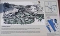
 view gallery view gallerySW31.5 km |  Umpqua Tribe Umpqua Tribe
in Oregon Historical Markers This group of signs is located at the Colliding Rivers Viewpoint in Glide, Oregon. posted by: Volcanoguy location: Oregon date approved: 01/21/2007 last visited: 05/06/2023 |
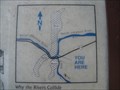 view gallery view gallerySW31.5 km | Colliding Rivers, Glide Oregon in 'You Are Here' Maps This "You Are Here" map is located on the scenic overlook of the location where 2 rivers (Umpqua and Little Rivers) collide head-on. posted by: Queens Blessing location: Oregon date approved: 07/15/2009 last visited: 05/06/2023 |
 view gallery view gallerySW31.5 km |  Colliding Rivers Viewpoint, Oregon Colliding Rivers Viewpoint, Oregon
in Scenic Roadside Look-Outs The Colliding Rivers Viewpoint is located in Glide, Oregon. posted by: Volcanoguy location: Oregon date approved: 01/21/2007 last visited: 05/06/2023 |
 view gallery view gallerySW31.5 km | Colliding Rivers in Oregon Historical Markers This sign is located at the Colliding Rivers Viewpoint in Glide, Oregon. posted by: Volcanoguy location: Oregon date approved: 01/21/2007 last visited: 05/06/2023 |
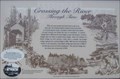 view gallery view gallerySW31.5 km | Crossing the River Through Time in Oregon Historical Markers This sign is located at the Colliding Rivers Viewpoint in Glide, Oregon. posted by: Volcanoguy location: Oregon date approved: 01/21/2007 last visited: 05/06/2023 |
 view gallery view gallerySW31.5 km |  CONFLUENCE-Little River-North Umpqua River CONFLUENCE-Little River-North Umpqua River
in River Origins, Destinations and Confluences These two rivers collide near Glide, Oregon.
N 43° 17.861 W 123° 06.080 posted by: Queens Blessing location: Oregon date approved: 02/17/2013 last visited: 05/06/2023 |
 view gallery view gallery NW36.5 km NW36.5 km
| Mosby Creek (Stewart) Covered Bridge, Oregon in Covered Bridges Mosby Creek (Stewart) Covered Bridge is located about a mile east of Cottage Grove, Oregon. posted by: Rose Red location: Oregon date approved: 02/14/2012 last visited: 01/29/2015 |
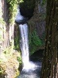 view gallery view gallerySE37.2 km |  Toketee Falls, Oregon Toketee Falls, Oregon
in Waterfalls The spectacular Toketee Falls on North Umpqua River. posted by: Volcanoguy location: Oregon date approved: 12/13/2005 last visited: 05/06/2023 |
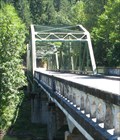 view gallery view gallery NE38 km NE38 km
|  Judge Charles Barnard Bridge near Westfir, Oregon Judge Charles Barnard Bridge near Westfir, Oregon
in Truss Bridges This bridge is dedicated to Charles Barnard, Lane County judge from 1921-1932. posted by: Queens Blessing location: Oregon date approved: 08/22/2009 last visited: 09/15/2012 |
|