 view gallery view gallery S16.9 km S16.9 km
|   Sheep Bridge Sheep Bridge
in Pedestrian Suspension Bridges Short drive south of Hwy 20 between Hwy 75 and Fairfield, ID. posted by:  greywolf1242 greywolf1242 location: Idaho date approved: 05/12/2007 last visited: 10/05/2012 |
 view gallery view gallery N25.1 km N25.1 km
|  Ernest Hemingway - Ketchum, ID Ernest Hemingway - Ketchum, ID
in Grave of a Famous Person Grave of journalist, Pulitzer Prize-winning author and Nobel laureate in literature, Ernest Hemingway. posted by:  hykesj hykesj location: Idaho date approved: 03/04/2023 last visited: never |
 view gallery view galleryS31.5 km |  Antique Case Antique Case
in Old Tractors A very old steam powered Case. posted by: muddawber location: Idaho date approved: 04/28/2006 last visited: 06/19/2009 |
 view gallery view gallery SE32.3 km SE32.3 km
|  Carey, ID 83320 Carey, ID 83320
in U.S. Post Offices Small post office in the small town of Carey, ID. posted by: greywolf1242 location: Idaho date approved: 03/20/2007 last visited: 09/23/2010 |
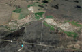
 view gallery view galleryS32.7 km |  Magic Dam Magic Dam
in Idaho Historical Markers Completed in 1910 at a cost of $3,000,000, Magic Dam stores water for 89,000 acres of irrigated farms. posted by: muddawber location: Idaho date approved: 12/20/2006 last visited: never |
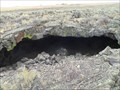
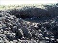
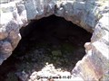
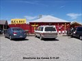 view gallery view galleryS34.1 km | ") Shoshone Indian Ice Caves Shoshone Indian Ice Caves
in Cave Entrances (Natural) Located 17 miles north of Shoshone, ID on Scenic Hwy 75. posted by: greywolf1242 location: Idaho date approved: 05/12/2007 last visited: never |
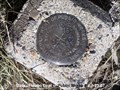
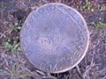 view gallery view gallery NW35.2 km NW35.2 km
|  Dollarhide Summit Benchmark Dollarhide Summit Benchmark
in U.S. Benchmarks USGS Benchmark Disk located at the top of Dollarhide Summit, near Ketchum Idaho. posted by: 1450Crew location: Idaho date approved: 06/20/2009 last visited: never |
 view gallery view galleryS35.4 km |  The Cottonwoods - near Shoshone, Idaho USA The Cottonwoods - near Shoshone, Idaho USA
in Best Kept Secrets Early Idaho history mentions "The Cottonwoods" in stories of dusty travelers and bandits, but modern treasure hunters can hardly find "The Cottonwoods" in their search for Idaho's best kept secret of legendary gold hidden in volcanic desert caves. posted by: jwanlesss location: Idaho date approved: 04/01/2021 last visited: never |
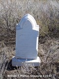 view gallery view gallery SW36.7 km SW36.7 km
|  William T Phillips Gravesite William T Phillips Gravesite
in Out of Place Graves Gravesite of William T Phillips posted by: greywolf1242 location: Idaho date approved: 03/24/2007 last visited: never |
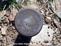
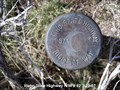 view gallery view gallerySW39.8 km | Idaho State Highway R/W # 82 in U.S. Benchmarks This is an Idaho State Highway right of way marker. posted by: greywolf1242 location: Idaho date approved: 03/24/2007 last visited: never |
 view gallery view galleryS39.9 km | Sundial Cave - near Richfield, Idaho USA in Cave Entrances (Natural) Unique cave with a hole in its roof that puts a spot of sunlight on a large tilted boulder on the cave floor. posted by: jwanlesss location: Idaho date approved: 04/13/2021 last visited: 02/02/2022 |
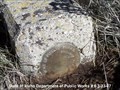
 view gallery view gallerySW40.1 km | State of Idaho Dept of Public Works # 8 in U.S. Benchmarks This is a State of Idaho Public Works right of way marker. posted by: greywolf1242 location: Idaho date approved: 03/24/2007 last visited: never |
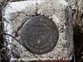 view gallery view gallerySW40.1 km | State of Idaho Dept of Public Works # 7 in U.S. Benchmarks This is a State of Idaho Dept of Public Works right of way marker. posted by: greywolf1242 location: Idaho date approved: 03/24/2007 last visited: never |
 view gallery view gallerySW40.1 km | Idaho State Highway R/W # 83 in U.S. Benchmarks This is an Idaho State Highway right of way marker. posted by: greywolf1242 location: Idaho date approved: 03/24/2007 last visited: never |
 view gallery view gallerySW40.7 km | Idaho State Highway R/W # 84 in U.S. Benchmarks This is an Idaho State Highway right of way marker.
posted by: greywolf1242 location: Idaho date approved: 03/24/2007 last visited: never |
 view gallery view gallerySW41.2 km | Idaho State Highway R/W # 81 in U.S. Benchmarks An Idaho State Highway right of way marker. posted by: greywolf1242 location: Idaho date approved: 03/24/2007 last visited: never |
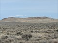 view gallery view galleryS42.3 km |  Kinzie Butte - north of Shoshone, Idaho USA Kinzie Butte - north of Shoshone, Idaho USA
in Volcano Watching A prominent shield volcano in west-central Lincoln County's lava field desert. posted by: jwanlesss location: Idaho date approved: 04/14/2021 last visited: never |
 view gallery view gallerySW42.5 km | Idaho State Highway R/W 199.0 RT in U.S. Benchmarks This is an Idaho State Highway Right of Way marker. posted by: greywolf1242 location: Idaho date approved: 05/09/2007 last visited: never |
 view gallery view gallerySW42.6 km | Idaho State Highway R/W # 80 in U.S. Benchmarks An Idaho State Highway right of way marker. posted by: greywolf1242 location: Idaho date approved: 03/24/2007 last visited: never |
 view gallery view gallerySW42.6 km | Idaho State Highway R/W # 79 in U.S. Benchmarks This is an Idaho State Highway right of way marker. posted by: greywolf1242 location: Idaho date approved: 03/24/2007 last visited: never |
 view gallery view gallerySW42.8 km | State of Idaho Dept of Public Works # 9 in U.S. Benchmarks This is a State of Idaho Dept of Public Works right of way marker. posted by: greywolf1242 location: Idaho date approved: 03/24/2007 last visited: never |
 view gallery view gallerySW43.1 km | State of Idaho Dept of Public Works # 6 in U.S. Benchmarks A State of Idaho Dept of Public Works right of way marker. posted by: greywolf1242 location: Idaho date approved: 03/24/2007 last visited: never |
 view gallery view galleryS44.4 km | Big Arch Cave in Cave Entrances (Natural) A short drive off the main track road north of Idaho's Mammoth Cave. posted by: greywolf1242 location: Idaho date approved: 05/11/2007 last visited: never |
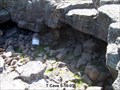 view gallery view galleryS44.4 km | T Cave in Cave Entrances (Natural) A short drive off the main track road north of Idaho's Mammoth Cave. posted by: greywolf1242 location: Idaho date approved: 05/11/2007 last visited: 06/17/2011 |
 view gallery view galleryS45.2 km | Gwinn Cave in Cave Entrances (Natural) Short drive west of Hwy 75 north of Shoshone, ID. posted by: greywolf1242 location: Idaho date approved: 05/11/2007 last visited: 06/17/2011 |
|