 view gallery view gallery NE2.3 km NE2.3 km
|   Labyrinth Garden peace pole - West Bend, WI Labyrinth Garden peace pole - West Bend, WI
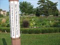
in Peace Poles An eight-sided peace pole near the labyrinth garden in Regner Park. posted by:  adgorn adgorn location: Wisconsin date approved: 02/21/2018 last visited: 08/17/2015 |
 view gallery view galleryNE2.3 km |  Labyrinth Garden - West Bend, WI Labyrinth Garden - West Bend, WI
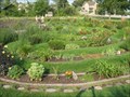
in Labyrinths Labyrinth Garden near the North Main Street entrance to Regner Park, West Bend, WI. Built in 2005 by an all volunteer workforce, the Labyrinth Garden Earth Sculpture was designed in the tradition of 7-circuit Cretan labyrinth, 90 feet in diameter. posted by: adgorn location: Wisconsin date approved: 09/09/2013 last visited: 08/17/2015 |
 view gallery view gallery N3.9 km N3.9 km
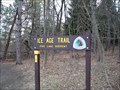
|  Ice Age Trail - West Bend Segment Ice Age Trail - West Bend Segment
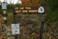
in Ice Age Trail Trailhead sign in West Bend, WI posted by: The Troops location: Wisconsin date approved: 10/14/2012 last visited: 08/12/2023 |
 view gallery view gallery W5 km W5 km
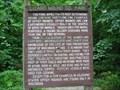
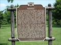
|  Great Divide Great Divide
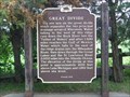
in Wisconsin Historical Markers Great Divide Marker in West Bend. posted by: frankhj location: Wisconsin date approved: 07/30/2007 last visited: 08/12/2023 |
 view gallery view galleryNE7.4 km | Lizard Mound Co. Park in Wisconsin Historical Markers Lizard Mound Co. Park Marker NW of West Bend. This is one of the oldest markers, listed as #17. It is listed as a State Park, but was taken over by Washington County in 1986. posted by: frankhj location: Wisconsin date approved: 07/30/2007 last visited: 09/14/2009 |
 view gallery view gallery S10 km S10 km
|  ML-D1A: Mayfield Roller Mills on Cedar Creek ML-D1A: Mayfield Roller Mills on Cedar Creek
in U.S. Benchmarks "Railroad commission of Wisconsin, Water-Power" benchmark in Mayfield, WI at the former site of the Mayfield Roller Mills. posted by: Icestationzeba location: Wisconsin date approved: 09/20/2014 last visited: never |
 view gallery view gallery SW10.6 km SW10.6 km
|  Lovers Ln Water Tower - Slinger, WI Lovers Ln Water Tower - Slinger, WI
in Water Towers This water tower is at the end of Lovers Ln in Slinger, WI. posted by: REUAHNESIE location: Wisconsin date approved: 06/22/2010 last visited: never |
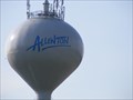 view gallery view galleryW10.8 km | Hwy 41 Water Tower - Allenton, WI in Water Towers This water tower is just off US HWY 41 at Allenton, WI. posted by: REUAHNESIE location: Wisconsin date approved: 06/22/2010 last visited: never |
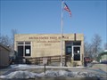 view gallery view galleryS10.8 km |  Jackson, WI 53037 Jackson, WI 53037
in U.S. Post Offices This is the old post office in Jackson WI from what i have been told. The new one opened a few weeks after i took this photo.. I have not been back home since this photo to go see the new one yet but would like to when i get time off from the army. posted by:  PostOfficeMan PostOfficeMan location: Wisconsin date approved: 07/25/2007 last visited: 12/30/2007 |
 view gallery view gallerySW13.8 km | Pike Lake Unit Trailhead - Kettle Moraine State Forest; Washington County, WI in Ice Age Trail A centrally located trailhead in the Pike Lake Unit of the Kettle Moraine State Forest. posted by: cldisme location: Wisconsin date approved: 12/25/2011 last visited: 08/24/2018 |
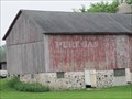 view gallery view galleryN14.2 km |  Pure Gas sign on Highway 45, Kewaskum, WI Pure Gas sign on Highway 45, Kewaskum, WI
in Ghost Signs This "Pure Gas" ghost sign is on the north side of a rustic barn on Highway 45 north of Kewaskum, Wisconsin. posted by: swamp soggin location: Wisconsin date approved: 11/30/2014 last visited: 11/29/2014 |
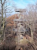 view gallery view gallerySW14.3 km |  Powder Hill Observation Tower - Pike Lake Unit; Kettle Moraine State Forest; Washington County, WI Powder Hill Observation Tower - Pike Lake Unit; Kettle Moraine State Forest; Washington County, WI
in Look-Out Towers A new observation tower on top of Powder Hill posted by: cldisme location: Wisconsin date approved: 11/28/2011 last visited: 09/13/2019 |
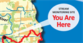 view gallery view gallery E14.6 km E14.6 km
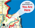
|  Riveredge Creek Riveredge Creek
in 'You Are Here' Maps This sign denotes a Water Action Volunteers monitoring site on Riveredge Creek. posted by: VolunteerStream location: Wisconsin date approved: 10/06/2014 last visited: never |
 view gallery view galleryS15.4 km |  Cabela's - Richfield Cabela's - Richfield
in Outdoor Recreation Stores Located in Richfield, WI posted by: The Troops location: Wisconsin date approved: 10/26/2012 last visited: 08/19/2018 |
 view gallery view gallerySW17.4 km | "Kissel" in Wisconsin Historical Markers "Kissel" Marker in Hartford. posted by: frankhj location: Wisconsin date approved: 08/16/2007 last visited: never |
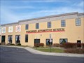 view gallery view gallerySW17.9 km |  Wisconsin Automotive Museum - Hartford, WI Wisconsin Automotive Museum - Hartford, WI
in Motor Vehicle Museums Specializing in cars built in Wisconsin but displays many others. posted by: cldisme location: Wisconsin date approved: 12/26/2011 last visited: never |
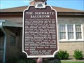 view gallery view gallerySW18.3 km | Schwartz Ballroom, The in Wisconsin Historical Markers The Schwartz Ballroom Marker in Hartford. The address in the list is 700 S. Main St., which does not exist. I almost did not find it. The real address is 150 Jefferson Ave. This is a 2 sided marker with the story continued on the back. posted by: frankhj location: Wisconsin date approved: 08/16/2007 last visited: 03/16/2019 |
 view gallery view gallerySW18.3 km |  Schwartz Ballroom - Hartford, WI Schwartz Ballroom - Hartford, WI
in U.S. National Register of Historic Places The Schwartz Ballroom in Hartford, WI. posted by: frankhj location: Wisconsin date approved: 08/17/2007 last visited: 09/23/2007 |
 view gallery view gallery SE18.3 km SE18.3 km
| Last Covered Bridge in Wisconsin Historical Markers Last Covered Bridge Marker N. of Five Corners which is N. of Cedarburg. I think we need a Five Corners category. I know of at least 3 in Wisconsin. posted by: frankhj location: Wisconsin date approved: 07/26/2007 last visited: 07/26/2021 |
 view gallery view gallerySE18.5 km | Cedar Creek in 'You Are Here' Maps This sign denotes a Water Action Volunteers monitoring site on Cedar Creek. posted by: VolunteerStream location: Wisconsin date approved: 10/15/2014 last visited: never |
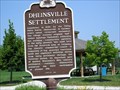 view gallery view galleryS19.2 km | Dheinsville Settlement in Wisconsin Historical Markers Dheinsville Settlement Marker in Dheinsville. posted by: frankhj location: Wisconsin date approved: 08/16/2007 last visited: 03/15/2019 |
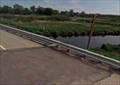 view gallery view galleryS19.3 km | 96070 - Wisconsin Division of Highways in U.S. Benchmarks Wisconsin Highway marker located on bridge spanning creek. posted by: Icestationzeba location: Wisconsin date approved: 05/12/2018 last visited: never |
 view gallery view galleryE19.5 km | Birthplace of Flag Day in Wisconsin Historical Markers Marks the school house where Flag Day started on June 14, 1885. posted by: frankhj location: Wisconsin date approved: 07/19/2007 last visited: 08/10/2019 |
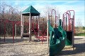 view gallery view galleryS20.6 km |  Homestead Hollow County Park Homestead Hollow County Park
in Public Playgrounds A large park with playground and wooded nature trails in Germantown, WI. posted by: LOST_Mom location: Wisconsin date approved: 11/24/2007 last visited: 11/08/2007 |
 view gallery view gallerySE21.1 km | Centennial Park - Cedarburg, WI in Public Playgrounds Centennial Park is located on Evergreen Blvd in the town of Cedarburg, WI. posted by: LOST_Mom location: Wisconsin date approved: 11/09/2007 last visited: 10/17/2007 |
|