 view gallery view gallery SW12.2 km SW12.2 km
|   Silos and Smokestacks NHA - Vesterheim Museum Silos and Smokestacks NHA - Vesterheim Museum
in NPS Passport Cancellation Stations The Vesterheim Norwegian-American Museum is part of the Silos and Smokestacks National Heritage Area. posted by:  The WBs The WBs location: Iowa date approved: 04/27/2011 last visited: 06/20/2016 |
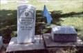 view gallery view gallerySW12.4 km |  Luman L. Cadwell-Decorah, IA Luman L. Cadwell-Decorah, IA
in Medal Of Honor Resting Places Civil War Medal of Honor Recipient for action at Alabama Bayou, LA on September 20, 1864. He is buried in Phelps Cemetery, Decorah, IA in Section “O”, Lot 77. posted by:  Don.Morfe Don.Morfe location: Iowa date approved: 07/23/2018 last visited: 12/11/2021 |
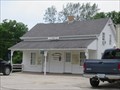
 view gallery view gallery SE17.2 km SE17.2 km
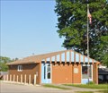
|  Waukon, Iowa 52172 Waukon, Iowa 52172
in U.S. Post Offices This Post Office is located at 113 W Main Street in Waukon, Iowa. posted by: brwhiz location: Iowa date approved: 06/28/2013 last visited: never |
 view gallery view gallerySE19 km |  Major General John Stark - Concord, NH Major General John Stark - Concord, NH
in U.S. Revolutionary War Memorials New Hampshire's most famous soldier posted by: YoSam. location: New Hampshire date approved: 09/06/2016 last visited: never |
 view gallery view gallery NW20.4 km NW20.4 km
|  Laura Ingalls Cutouts - Burr Oak, IA Laura Ingalls Cutouts - Burr Oak, IA
in Photo Cutouts These cutouts represent the Ingalls family during the time they lived in Burr Oak. posted by: wildernessmama location: Iowa date approved: 07/12/2016 last visited: never |
 view gallery view galleryNW20.4 km |  Burr Oak House/Masters Hotel – Burr Oak, IA Burr Oak House/Masters Hotel – Burr Oak, IA
in U.S. National Register of Historic Places The Burr Oak House/Masters Hotel is best known for its occupants, Laura Ingalls Wilder and her family when they lived here and managed the hotel in 1876. posted by: wildernessmama location: Iowa date approved: 07/12/2016 last visited: never |
 view gallery view galleryNW20.4 km | Burr Oak Savings Bank – Burr Oak, IA in U.S. National Register of Historic Places Burr Oak Savings Bank has seen a lot of action over its lifetime. posted by: wildernessmama location: Iowa date approved: 07/12/2016 last visited: never |
 view gallery view galleryNW20.4 km |  Burr Oak Savings Bank – Burr Oak, IA Burr Oak Savings Bank – Burr Oak, IA
in Converted Bank Buildings Burr Oak Savings Bank has seen a lot of action over its lifetime. posted by: wildernessmama location: Iowa date approved: 07/11/2016 last visited: never |
 view gallery view galleryNW29.5 km |  ON0972 ~ CANTON MUNICIPAL TANK ON0972 ~ CANTON MUNICIPAL TANK
in U.S. Benchmarks This Survey Mark is the top center of the elevated water tank located on the south side of Prairie Avenue behind the the Canton Fire Department at 105 S Main Street in Canton, Minnesota. posted by: brwhiz location: Minnesota date approved: 07/14/2013 last visited: never |
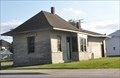 view gallery view galleryNW29.5 km |  Canton Railroad Station Canton Railroad Station
in Train Stations/Depots This vintage Railroad Station is located on the northeast corner of the intersection of Prairie Avenue and Main Street in central Canton, Minnesota. posted by: brwhiz location: Minnesota date approved: 07/14/2013 last visited: never |
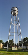 view gallery view galleryNW29.5 km |  Canton Water Tower Canton Water Tower
in Water Towers This Water Tower is located on the south side of Prairie Avenue behind the the Canton Fire Department at 105 S Main Street in Canton, Minnesota. posted by: brwhiz location: Minnesota date approved: 07/14/2013 last visited: never |
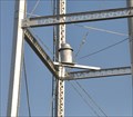 view gallery view galleryNW29.5 km |  Canton Warning Siren Canton Warning Siren
in Outdoor Warning Sirens This Outdoor Warning Siren is mounted on the support structure for the water tower located on the south side of Prairie Avenue behind the the Canton Fire Department at 105 S Main Street in Canton, Minnesota. posted by: brwhiz location: Minnesota date approved: 07/17/2013 last visited: never |
 view gallery view galleryNW29.6 km | Canton, Minnesota 55922 in U.S. Post Offices This Post Office is located at 308 N Main Street in Canton, Minnesota. posted by: brwhiz location: Minnesota date approved: 06/29/2013 last visited: never |
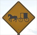 view gallery view galleryNW29.9 km |  Horse and Buggy on the Highway Horse and Buggy on the Highway
in Uncommon Crossing Signs This Unusual Crossing Sign is located on the north side of US Highway 52 just west of Canton, Minnesota. posted by: brwhiz location: Minnesota date approved: 08/04/2013 last visited: 10/13/2017 |
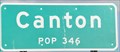 view gallery view galleryNW30.6 km |  Canton ~ Population 346 Canton ~ Population 346
in Population Signs This Population Sign is on the south side of US Highway 52 at the western town limits of Canton, Minnesota. posted by: brwhiz location: Minnesota date approved: 07/22/2013 last visited: never |
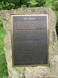 view gallery view gallery N32.3 km N32.3 km
|  Big Spring – Caledonia, MN Big Spring – Caledonia, MN
in Minnesota Historical Markers The Big Spring historical marker is near the creek just past the campground in Beaver Creek Valley State Park. posted by: wildernessmama location: Minnesota date approved: 07/05/2016 last visited: never |
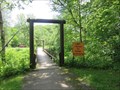 view gallery view galleryN32.7 km |  Beaver Creek Suspension Bridge - Caledonia, MN Beaver Creek Suspension Bridge - Caledonia, MN
in Pedestrian Suspension Bridges This pedestrian swinging bridge is located in Beaver Creek Valley State Park. posted by: wildernessmama location: Minnesota date approved: 07/06/2016 last visited: 03/31/2023 |
 view gallery view galleryNW32.8 km |  Iowa/Minnesota Border on State Highway 139 Iowa/Minnesota Border on State Highway 139
in Border Crossings You cross the Iowa/Minnesota border travelling on State Highway 139 between Cresco in Iowa and Harmony in Minnesota. posted by: brwhiz location: Minnesota date approved: 07/14/2013 last visited: never |
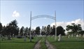
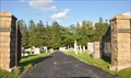
 view gallery view galleryNW32.8 km |  Stateline Cemetery Entrance Arch Stateline Cemetery Entrance Arch
in Freestanding Arches This Freestanding Arch arcs over the entrance to the Stateline Methodist Cemetery located on the northwest corner of the intersection of Stateline Road and Wisconsin Highway 139 about 3.3 miles south of Harmony, Minnesota. posted by: brwhiz location: Minnesota date approved: 07/15/2013 last visited: never |
 view gallery view galleryNW32.8 km |  Stateline Methodist Cemetery Stateline Methodist Cemetery
in Worldwide Cemeteries This Cemetery is located on the northwest corner of the intersection of Stateline Road and Minnesota Highway 139 about 3.3 miles south of Harmony, Minnesota. posted by: brwhiz location: Minnesota date approved: 07/15/2013 last visited: never |
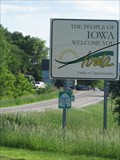 view gallery view gallery NE34.3 km NE34.3 km
| Iowa/Minnesota Border – Rural New Albin, IA in Border Crossings The Iowa/Minnesota border has signs welcoming travelers to both states. posted by: wildernessmama location: Iowa date approved: 06/26/2013 last visited: never |
 view gallery view galleryNW34.4 km | Harmony ~ Population 1020 in Population Signs This Population Sign is on the north side of US Highway 52 at the eastern city limits of Harmony, Minnesota. posted by: brwhiz location: Minnesota date approved: 07/14/2013 last visited: never |
 view gallery view galleryNW35.4 km | Greenfield Cemetery in Worldwide Cemeteries This Cemetery is located on both sides of Minnesota Highway 139 on the south edge of Harmony, Minnesota. posted by: brwhiz location: Minnesota date approved: 07/15/2013 last visited: never |
 view gallery view galleryNW35.6 km | Harmony ~ Population 1020 in Population Signs This Population Sign is on the east side of Minnesota Highway 139 at the southern city limits of Harmony, Minnesota. posted by: brwhiz location: Minnesota date approved: 07/14/2013 last visited: never |
 view gallery view gallery E35.7 km E35.7 km
|  Skinny Dip Ice Cream Shop – Lansing, IA Skinny Dip Ice Cream Shop – Lansing, IA
in Ice Cream Parlors The two giant ice cream cones are enough to get anyone’s attention on a hot summer day. posted by: wildernessmama location: Iowa date approved: 07/02/2013 last visited: never |
|