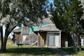
 view gallery view gallery NW8.4 km NW8.4 km
|   Christmas Valley Geodesic Home - Christmas Valley, OR Christmas Valley Geodesic Home - Christmas Valley, OR
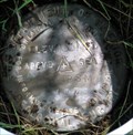
in Geodesic Domes This geodesic home can be found in the extremely rural high desert area of Central Oregon in the tiny town of Christmas Valley. Find it near the intersection of BLM road 6109D and 5-14. Please respect private property and stay on the road. posted by:  Hikenutty Hikenutty location: Oregon date approved: 09/08/2008 last visited: never |
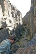 view gallery view galleryNW14.5 km |  Crack in the Ground - Lake County, OR Crack in the Ground - Lake County, OR
in Places of Geologic Significance Crack in the Ground is a tension fracture that formed when the Green Mountain lava flows draped over the upthrown side of a fault zone. Visitors can hike the length of the 2 mile long fissure. posted by: Hikenutty location: Oregon date approved: 09/09/2008 last visited: 10/01/2021 |
 view gallery view gallery NE16.6 km NE16.6 km
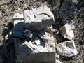
|  Petrified Bones - Fossil Lake, Oregon Petrified Bones - Fossil Lake, Oregon
in News Article Locations An 1877 New York Times article about Fossil Lake, Oregon. posted by:  Volcanoguy Volcanoguy location: Oregon date approved: 05/15/2011 last visited: 05/13/2011 |
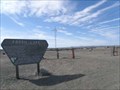
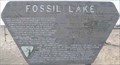 view gallery view galleryNE16.6 km |  Fossil Lake Fossil Lake
in Oregon Historical Markers History sign about the geology of Fossil Lake. The sign is located end of the road, at the boundary of the closed area. posted by: Volcanoguy location: Oregon date approved: 05/15/2011 last visited: 11/27/2020 |
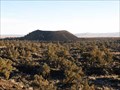 view gallery view gallery N17.2 km N17.2 km
|  Cone 1 of Four Craters Lava Field, Oregon Cone 1 of Four Craters Lava Field, Oregon
in Mountain Summits The southern most cinder cone of the Four Craters Lava Field. posted by: Volcanoguy location: Oregon date approved: 12/07/2013 last visited: 11/23/2013 |
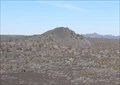 view gallery view galleryN18.7 km | Cone 2 of Four Craters Lava Field, Oregon in Mountain Summits The second from the south cinder cone of the Four Craters Lava Field. posted by: Volcanoguy location: Oregon date approved: 12/07/2013 last visited: 11/23/2013 |
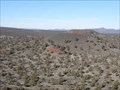 view gallery view galleryNW19.6 km | Cone 3 of Four Craters Lava Field, Oregon in Mountain Summits The third from the south cinder cone of the Four Craters Lava Field. posted by: Volcanoguy location: Oregon date approved: 12/07/2013 last visited: 11/23/2013 |
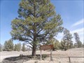
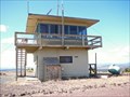 view gallery view galleryNW22.9 km |  Green Mountain Lookout Tower - Lake County, Oregon Green Mountain Lookout Tower - Lake County, Oregon
in Look-Out Towers The two story brick Green Mountain Lookout was built in 1963 and is operated by the BLM's Lakeview District in Lake County, Oregon. It has an elevation of 5,190 feet and is still in operation as a fire lookout. posted by: Hikenutty location: Oregon date approved: 09/05/2008 last visited: 05/30/2011 |
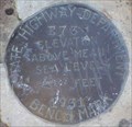
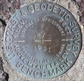
 view gallery view galleryNE23.7 km |  PB0056 - USCGS C91, Oregon PB0056 - USCGS C91, Oregon
in U.S. Benchmarks U.S. Coast & Geodetic Survey benchmark C91. posted by: Volcanoguy location: Oregon date approved: 05/31/2009 last visited: 04/07/2009 |
 view gallery view galleryNE24.3 km |  Lost Forest Research Natural Area Lost Forest Research Natural Area
in Flora and Fauna Information Signs A remnant forest resulting from unique geologic conditions. posted by: Volcanoguy location: Oregon date approved: 05/16/2011 last visited: 05/13/2011 |
 view gallery view gallery SW24.8 km SW24.8 km
| PB0590 - OSHD E73, OR in U.S. Benchmarks Oregon State Highway Department bench mark E73. posted by: Volcanoguy location: Oregon date approved: 09/30/2007 last visited: 09/30/2007 |
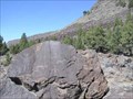
 view gallery view gallerySW24.8 km |  Picture Rock - Outback Scenic Byway - Oregon Picture Rock - Outback Scenic Byway - Oregon
in National Scenic Byways Picture Rock Pass is located along Central Oregon's "Outback" and is named for the petroglyphs that can be found on the volcanic rocks that are within walking distance of the road. posted by: Hikenutty location: Oregon date approved: 09/08/2008 last visited: 09/30/2012 |
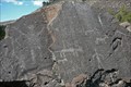
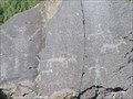 view gallery view gallerySW24.8 km |  Picture Rock Pass Petroglyphs, OR Picture Rock Pass Petroglyphs, OR
in Pictographs Petroglyphs at Picture Rock Pass on Ore. Hwy. 31 posted by: Volcanoguy location: Oregon date approved: 10/01/2007 last visited: 10/10/2014 |
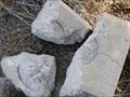
 view gallery view gallerySW24.8 km |  Picture Rock Pass Petroglyphs Site Picture Rock Pass Petroglyphs Site
in U.S. National Register of Historic Places Petroglyph site at Picture Rock Pass on Ore. Hwy. 31 posted by: Volcanoguy location: Oregon date approved: 11/13/2007 last visited: 11/13/2007 |
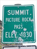 view gallery view gallerySW24.8 km |  Picture Rock Pass - 4830' Picture Rock Pass - 4830'
in Elevation Signs Highway 31 between Silver Lake and Summer Lake. posted by: WR7X location: Oregon date approved: 05/25/2013 last visited: never |
 view gallery view galleryNE25.7 km | PB0014 - USCGS B91, Oregon in U.S. Benchmarks U.S. Coast & Geodetic Survey benchmark B91. posted by: Volcanoguy location: Oregon date approved: 05/31/2009 last visited: 04/07/2009 |
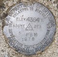
 view gallery view galleryN26.6 km | PB0843 - USGS 4PSM, Oregon in U.S. Benchmarks U.S. Geological Survey elevation mark 4PSM. posted by: Volcanoguy location: Oregon date approved: 06/20/2009 last visited: 06/20/2009 |
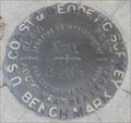
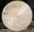 view gallery view galleryN26.6 km | T24-25S, R17E, CC Sec. 1 & 2, Oregon in U.S. Benchmarks Lake County Surveyor Cadastral mark for the Closing Corner between sections 1 & 2, of T25S, R17E. posted by: Volcanoguy location: Oregon date approved: 06/20/2009 last visited: 06/20/2009 |
 view gallery view gallerySW26.6 km | PB0599 - USCGS W72, OR in U.S. Benchmarks U.S. Coast & Geodetic Survey bench mark W72. posted by: Volcanoguy location: Oregon date approved: 09/30/2007 last visited: 09/30/2007 |
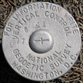 view gallery view galleryNE27.2 km | PB0063 - NGS G421, Oregon in U.S. Benchmarks National Geodetic Survey vertical control mark G421. posted by: Volcanoguy location: Oregon date approved: 05/31/2009 last visited: 04/07/2009 |
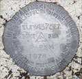
 view gallery view galleryN27.7 km | PB0844 - USGS 5PSM, Oregon in U.S. Benchmarks U.S. Geological Survey elevation mark 5PSM.
posted by: Volcanoguy location: Oregon date approved: 06/20/2009 last visited: 06/12/2009 |
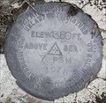
 view gallery view galleryN28.5 km | PB0845 - USGS 6PSM, Oregon in U.S. Benchmarks U.S. Geological Survey elevation mark 6PSM. posted by: Volcanoguy location: Oregon date approved: 06/20/2009 last visited: 06/12/2009 |
 view gallery view galleryNE28.6 km | PB0013 - USCGS A91, Oregon in U.S. Benchmarks U.S. Coast & Geodetic Survey benchmark A91. posted by: Volcanoguy location: Oregon date approved: 05/31/2009 last visited: 04/07/2009 |
 view gallery view galleryN29.5 km | PB0846 - USGS 7PSM, Oregon in U.S. Benchmarks U.S. Geological Survey elevation mark 7PSM. posted by: Volcanoguy location: Oregon date approved: 06/20/2009 last visited: 06/12/2009 |
 view gallery view gallerySW30.3 km |  Summer Lake Rest Area, Oregon Summer Lake Rest Area, Oregon
in Highway Rest Areas The Summer Lake Rest Area on Ore. Hwy. 31. posted by: Volcanoguy location: Oregon date approved: 10/01/2007 last visited: 10/01/2007 |
|