 view gallery view gallery SW26.4 km SW26.4 km
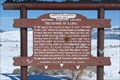
|   THE NAMING OF A LAKE (Replaced) THE NAMING OF A LAKE (Replaced)
in Wyoming Historical Markers On the edge of this magnificent sheet of water, from 1833 to 1844, Captain William Drummond Stewart of Scotland, camped many times with Jim Bridger and other Mountain Men and the Indians. posted by:  JacobBarlow JacobBarlow location: Wyoming date approved: 03/14/2008 last visited: 03/12/2011 |
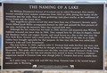 view gallery view gallerySW26.4 km | The Naming of a Lake in Wyoming Historical Markers This sign replaces an older sign at this location with the same title but entirely different wording. posted by: brwhiz location: Wyoming date approved: 09/25/2012 last visited: never |
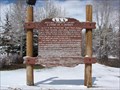
 view gallery view gallerySW26.4 km |  First Wyoming Tourist First Wyoming Tourist
in First of its Kind Sir William Drummond Stewart of Scotland was Wyoming’s first tourist. posted by: brwhiz location: Wyoming date approved: 09/25/2012 last visited: never |
 view gallery view gallerySW26.4 km | First Trip West by John C. Fremont in First of its Kind Explorer John C. Fremont made his first trip to the West in 1842. posted by: brwhiz location: Wyoming date approved: 09/25/2012 last visited: never |
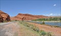
 view gallery view gallerySW26.4 km |  Last Green River Mountain Man Rendezvous Last Green River Mountain Man Rendezvous
in Last of its Kind The last rendezvous by the mountain men in the Green River area of Wyoming was in 1840. posted by: brwhiz location: Wyoming date approved: 09/25/2012 last visited: never |
 view gallery view gallerySW29.6 km |  Pinedale, Wyoming area map Pinedale, Wyoming area map
in 'You Are Here' Maps A large map with a You Are Here in Pinedale, Wyoming. posted by: JacobBarlow location: Wyoming date approved: 03/14/2008 last visited: 09/08/2010 |
 view gallery view gallerySW29.8 km |  Log Cabin Motel ~ Pinedale, Wyoming Log Cabin Motel ~ Pinedale, Wyoming
in U.S. National Register of Historic Places This rustic auto court retains the feel of the early accomodations for automobile travelers in the West. posted by: brwhiz location: Wyoming date approved: 01/09/2011 last visited: never |
 view gallery view gallerySW29.8 km |  Log Cabin Motel (Pinedale, Wyoming) Log Cabin Motel (Pinedale, Wyoming)
in Wikipedia Entries The Camp of the Pines (now Log Cabin Motel) was built in 1929 to serve the growing auto tourism business, and was the first and only "cabin camp" built in Pinedale. posted by: brwhiz location: Wyoming date approved: 03/12/2011 last visited: never |
 view gallery view gallerySW29.8 km |  Log Cabin Motel - Pinedale, Wyoming Log Cabin Motel - Pinedale, Wyoming
in Chalet, Cottage, and Cabin Style Lodging The Camp of the Pines (now Log Cabin Motel) was built in 1929 to serve the growing auto tourism business, and was the first and only "cabin camp" built in Pinedale. The facility is on the National Register of Historic Places. posted by: brwhiz location: Wyoming date approved: 03/31/2011 last visited: 07/23/2012 |
 view gallery view gallerySW29.9 km |  Sublette County Visitors Center and Chamber of Commerce Sublette County Visitors Center and Chamber of Commerce
in Tourist Information Centers - Visitor Centers This Tourist Information Center is located at 19 E Pine Street in downtown Pinedale, Wyoming. posted by: brwhiz location: Wyoming date approved: 09/30/2012 last visited: never |
 view gallery view gallerySW29.9 km |  Working The Line ~ Pinedale, Wyoming Working The Line ~ Pinedale, Wyoming
in Figurative Public Sculpture This sculpture is located in front of the Sublette County Visitors Center at 19 E Pine Street in downtown Pinedale, Wyoming. posted by: brwhiz location: Wyoming date approved: 09/25/2012 last visited: never |
 view gallery view gallerySW30.3 km | A PAUSE ON A JOURNEY in Wyoming Historical Markers A marker located west of the Pine Creek Bridge in Pinedale, on the North side of the highway. posted by: JacobBarlow location: Wyoming date approved: 04/23/2007 last visited: 09/24/2010 |
 view gallery view gallerySW30.6 km |  Pinedale, Wyoming SUBWAY Pinedale, Wyoming SUBWAY
in Subway Restaurants I was up here in beautiful Pinedale for work and had lunch at this SUBWAY. posted by: JacobBarlow location: Wyoming date approved: 02/23/2007 last visited: 08/19/2009 |
 view gallery view gallerySW31.2 km | Pinedale, Wyoming in Wikipedia Entries Pinedale is the gateway to the Wind River Mountains, several miles east of town. posted by: brwhiz location: Wyoming date approved: 03/25/2011 last visited: 10/03/1982 |
 view gallery view gallerySW31.2 km |  Pinedale, Wyoming Pinedale, Wyoming
in Elevation Signs This combination sign announces population and elevation of Pinedale as you enter from the west on US Highway 191. posted by: brwhiz location: Wyoming date approved: 03/18/2011 last visited: never |
 view gallery view gallerySW33.3 km |  Welcome to the Riparian Community of Duck Creek Welcome to the Riparian Community of Duck Creek
in Flora and Fauna Information Signs This Wyoming Wildlife sign is located on the north side of US Highway 191 west of Pinedale and east of Wyoming Highway 352. posted by: brwhiz location: Wyoming date approved: 09/28/2012 last visited: never |
 view gallery view gallery S34.6 km S34.6 km
| Ralph Wenz Field - Elevation 7058 in Elevation Signs Wenz field is the municipal airport owned by the town of Pinedale, Wyoming. posted by: brwhiz location: Wyoming date approved: 06/02/2011 last visited: never |
 view gallery view galleryS34.6 km | Ralph Wenz Field - Pinedale, Wyoming in Wikipedia Entries Wenz Field is a small general aviation airfield owned by the town of Pinedale, Wyoming. It handles about 9500 flights per year. posted by: brwhiz location: Wyoming date approved: 06/02/2011 last visited: never |
 view gallery view galleryS34.6 km |  Wenz Field ~ Pinedale, WY Wenz Field ~ Pinedale, WY
in Airports Wenz Field, five miles south of Pinedale, Wyoming, was founded in 1937 by Jack Mudd. It is a general aviation field that serves as the municipal airport for Pinedale and the surrounding communities. posted by: brwhiz location: Wyoming date approved: 06/10/2011 last visited: never |
 view gallery view galleryS34.8 km | Osprey in Flora and Fauna Information Signs This Wyoming Wildlife sign is located on the east side of US Highway 191 south of Pinedale, Wyoming at Fayette Pole Creek Road, across from Wentz Field Airport. posted by: brwhiz location: Wyoming date approved: 09/28/2012 last visited: never |
 view gallery view gallerySW35.2 km |  Wind River Mountains - Bridger National Forest Wind River Mountains - Bridger National Forest
in Orientation Tables This large orientation table delineates each peak in the Wind River mountain range north and east of Pinedale, Wyoming. posted by: brwhiz location: Wyoming date approved: 04/11/2011 last visited: 07/23/2012 |
 view gallery view gallerySW35.2 km |  Wyoming Highway ROW SUPD-16Z Wyoming Highway ROW SUPD-16Z
in U.S. Benchmarks This is a WYDOT ROW marker located quite a distance from the highway atop a small hill. posted by: brwhiz location: Wyoming date approved: 06/02/2011 last visited: never |
 view gallery view gallerySW38.8 km | USCGS NT0008 U 44 - 1934 in U.S. Benchmarks This survey disk is located just west of US 189/191, north of the junction of the two highways north of Daniel, Wyoming. With its two witness posts, and surrounded by three wooden fence posts, it is easy to spot while traveling the highway. posted by: brwhiz location: Wyoming date approved: 06/02/2011 last visited: never |
 view gallery view gallery NE40.2 km NE40.2 km
|  Red Rock Wind River Scenic Look-Out ~ Burris, Wyoming Red Rock Wind River Scenic Look-Out ~ Burris, Wyoming
in Scenic Roadside Look-Outs This Scenic Roadside Look-Out is located on the northeast side of US Highway 26/287 about 10 miles northwest of Burris. posted by: brwhiz location: Wyoming date approved: 09/02/2013 last visited: never |
 view gallery view gallerySW41.7 km | First White Women in Wyoming in First of its Kind Two female missionaries who scored a couple of firsts in 1836. posted by: brwhiz location: Wyoming date approved: 04/06/2011 last visited: 06/17/2018 |
|