 view gallery view gallery NE3.4 km NE3.4 km
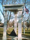
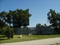
|   Veteran's Monument - Lake Mills, WI Veteran's Monument - Lake Mills, WI
in Non-Specific Veteran Memorials Generic Veteran's Monument in the city park.
posted by:  Not So Lost Puppies Not So Lost Puppies location: Wisconsin date approved: 11/19/2006 last visited: 11/19/2006 |
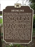 view gallery view galleryNE6.3 km |  Drumlins Historical Marker Drumlins Historical Marker
in Wisconsin Historical Markers Drumlins Historical Marker at Rest Area No. 13 on eastbound I-94 1 mile east of Lake Mills, WI posted by: onfire4jesus location: Wisconsin date approved: 08/20/2007 last visited: 03/19/2019 |
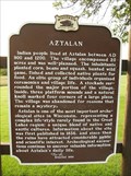 view gallery view gallery E6.4 km E6.4 km
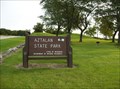
| Aztalan Historical Marker in Wisconsin Historical Markers Aztalan Historical Marker at the Aztalan State Park on Hwy Q 3 miles east of Lake Mills, WI posted by: onfire4jesus location: Wisconsin date approved: 08/20/2007 last visited: 04/14/2019 |
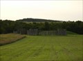 view gallery view galleryE6.4 km |  Aztalan - Aztalan, WI Aztalan - Aztalan, WI
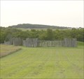
in U.S. National Register of Historic Places Indian people lived at Aztalan between AD 900 and 1200. The village encompassed 20 acres and was well-planned. The site is now part of the Aztalan State Park. posted by: onfire4jesus location: Wisconsin date approved: 02/25/2008 last visited: 06/22/2014 |
 view gallery view galleryE6.4 km |  Aztalan State Park Aztalan State Park
in Wikipedia Entries Aztalan State Park south of Aztalan, Wisconsin near Lake Mills posted by: onfire4jesus location: Wisconsin date approved: 08/23/2007 last visited: 08/18/2007 |
 view gallery view galleryE6.4 km |  Aztalan State Park - Wisconsin Aztalan State Park - Wisconsin
in State/Provincial Parks Aztalan State Park near Lake Mills, WI posted by: onfire4jesus location: Wisconsin date approved: 08/24/2007 last visited: 06/22/2014 |
 view gallery view galleryE6.4 km |  Aztalan Mound Park - Aztalan, WI Aztalan Mound Park - Aztalan, WI
in American Guide Series The Aztalan State Park contains ruins of a prehistoric Native American village. posted by: onfire4jesus location: Wisconsin date approved: 02/23/2008 last visited: 10/24/2007 |
 view gallery view galleryE6.4 km |  Aztalan - Lake Mills WI Aztalan - Lake Mills WI
in New World Ancient Evidence This large stockaded temple mound site, first discovered in 1836, is the northernmost of the major Mississipian culture archeological sites. It now forms Aztalan State Park. posted by:  nomadwillie nomadwillie location: Wisconsin date approved: 10/14/2014 last visited: never |
 view gallery view galleryE6.6 km | Pioneer Aztalan Site - Aztalan, WI in U.S. National Register of Historic Places Pioneer Aztalan was settled in 1836 by Thomas Brayton and others at the junction of the Milwaukee-Mineral Point and Janesville-Fond du Lac territorial roads. posted by: onfire4jesus location: Wisconsin date approved: 09/14/2007 last visited: 08/11/2007 |
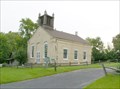 view gallery view galleryE6.6 km |  Lake Mills/Aztalan Museum Lake Mills/Aztalan Museum
in History Museums Lake Mills/Aztalan Museum located 1 Mile East of Lake Mills at the corner of HWY B & Q. posted by: onfire4jesus location: Wisconsin date approved: 08/23/2007 last visited: 08/18/2007 |
 view gallery view gallery SW8 km SW8 km
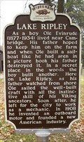
| Lake Ripley Historical Marker in Wisconsin Historical Markers The Lake Ripley Historical Marker is located in the Lake Ripley County Park off of Hwy 12 in Cambridge, WI posted by: onfire4jesus location: Wisconsin date approved: 11/20/2007 last visited: 04/14/2019 |
 view gallery view gallery SE9.7 km SE9.7 km
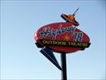
|  Googie sign for HWY 18 outdoor theater Googie sign for HWY 18 outdoor theater
in Googie Architecture An awesome sign! Very easy to spot from the road and in good googie shape. posted by: nneuman location: Wisconsin date approved: 01/20/2012 last visited: never |
 view gallery view gallerySE9.7 km |  Neon Outdoor Theatre Sign Neon Outdoor Theatre Sign
in Neon Signs A great old neon sign that still in use. I could only get a daytime picture. This sign is for the Hwt 18 Outdoor Theatre in Jefferson Wi posted by: nneuman location: Wisconsin date approved: 01/20/2012 last visited: never |
 view gallery view gallerySE9.7 km |  Highway 18 Outdoor Theater - Jefferson, WI Highway 18 Outdoor Theater - Jefferson, WI
in Drive-In Movie Theaters Located on Hwy 18, two miles west of Jefferson. posted by: Team LightningBugs location: Wisconsin date approved: 10/16/2008 last visited: 10/08/2011 |
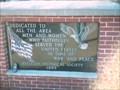
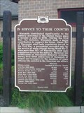 view gallery view galleryE10.1 km | In Service to Their Country in Wisconsin Historical Markers A marker noting Wisconsin's service in every war since it became a state in 1848. posted by:  The Cheeseheads The Cheeseheads location: Wisconsin date approved: 08/16/2007 last visited: 03/19/2019 |
 view gallery view gallery W10.8 km W10.8 km
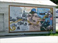
|  Deerfield Timeline - Deerfield, WI Deerfield Timeline - Deerfield, WI
in Murals An interesting timeline mural on the side of Cuda's Cafe, which also faces the Glacial Drumlin Trail. posted by: nneuman location: Wisconsin date approved: 09/26/2011 last visited: never |
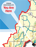 view gallery view gallerySW12.1 km |  Koshkonong Creek Koshkonong Creek
in 'You Are Here' Maps This sign denotes a Water Action Volunteers monitoring site on Koshkonong Creek posted by: VolunteerStream location: Wisconsin date approved: 09/24/2014 last visited: never |
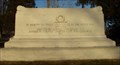
 view gallery view gallerySE12.6 km | Veteran's Memorial - Jefferson, WI in Non-Specific Veteran Memorials Honoring the area men and women who faithfully served the United States in time of War and Peace. posted by: Not So Lost Puppies location: Wisconsin date approved: 11/19/2006 last visited: 11/19/2006 |
![Image for [Legacy] A&W - Johnson Creek, Wisconsin](https://img.geocaching.com/waymarking/log/small/805cad01-5e54-45a9-9a5a-4677241bc4b9.png) view gallery view galleryE14.6 km |  [Legacy] A&W - Johnson Creek, Wisconsin [Legacy] A&W - Johnson Creek, Wisconsin
in A + W Restaurants This was a combination A&W, KFC, and gas station. posted by: SageInThyme82 location: Wisconsin date approved: 09/30/2015 last visited: 09/16/2005 |
 view gallery view gallerySE15.3 km |  World War Memorial - Fort Atkinson, WI World War Memorial - Fort Atkinson, WI
in World War I Memorials and Monuments Found in McCoy Park. posted by: Team LightningBugs location: Wisconsin date approved: 11/21/2006 last visited: 04/17/2011 |
 view gallery view gallerySE16.4 km |  Fort Koshkonong - Fort Atkinson, WI Fort Koshkonong - Fort Atkinson, WI
in Historic Forts On July 15, 1832, General Henry Atkinson finished erecting at the junction of the Rock and Bark Rivers a temporary stockade known as Fort Koshkonong. This replica of the Fort was built in the 1960s. It is located in Riverside park in Ft. Atkinson. posted by: onfire4jesus location: Wisconsin date approved: 11/21/2007 last visited: 10/19/2009 |
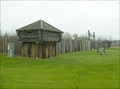 view gallery view gallerySE16.4 km | Fort Koshkonong - Fort Atkinson, WI in Wikipedia Entries On July 15, 1832, General Henry Atkinson finished erecting at the junction of the Rock and Bark Rivers a temporary stockade known as Fort Koshkonong. This replica of the Fort was built in the 1960s. It is located in Riverside park in Ft. Atkinson. posted by: onfire4jesus location: Wisconsin date approved: 02/25/2008 last visited: 11/17/2007 |
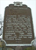 view gallery view gallerySE16.6 km | Panther Intaglio Historical Marker in Wisconsin Historical Markers The Panther Intaglio Historical Marker is located on Hwy 106 on the west side of Fort Atkinson, WI. posted by: onfire4jesus location: Wisconsin date approved: 11/20/2007 last visited: 11/17/2007 |
 view gallery view gallerySE16.6 km | Panther Intaglio Effigy Mound - Ft. Atkinson, WI in U.S. National Register of Historic Places Discovered in 1850, this is the only known intaglio Effigy mound in the world. It is located on Hwy 106 west of Ft. Atkinson, WI posted by: onfire4jesus location: Wisconsin date approved: 02/25/2008 last visited: 11/16/2004 |
 view gallery view gallerySE16.6 km | Panther Intaglio Effigy Mound - Ft. Atkinson, WI in New World Ancient Evidence Discovered in 1850, this is the only known intaglio Effigy mound in the world. It is located on Hwy 106 west of Ft. Atkinson, WI posted by: onfire4jesus location: Wisconsin date approved: 02/25/2008 last visited: 11/17/2007 |
|