 view gallery view gallery SW1.3 km SW1.3 km
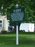
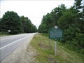
|   New Hampshire's Last Soldier of the Revolution New Hampshire's Last Soldier of the Revolution
in Last of its Kind This marker is located in Antrim on US 202 right neat the intersection with NH 31.
posted by:  nomadwillie nomadwillie location: New Hampshire date approved: 10/26/2009 last visited: 10/26/2009 |
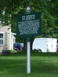 view gallery view gallerySW1.3 km |  New Hampshire's Last Soldier of the Revolution New Hampshire's Last Soldier of the Revolution
in New Hampshire Historical Markers This marker is located in Antrim on US 202 right neat the intersection with NH 31 posted by: nomadwillie location: New Hampshire date approved: 09/22/2009 last visited: 10/26/2009 |
 view gallery view gallery S3.7 km S3.7 km
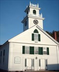
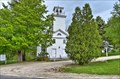
|  Bennington Congregational Church - Bennington, NH Bennington Congregational Church - Bennington, NH
in This Old Church This traditional New England church dates from 1839 and sits in the center of the small village of Bennington, New Hampshire. posted by:  silverquill silverquill location: New Hampshire date approved: 03/16/2008 last visited: never |
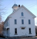 view gallery view galleryS3.9 km |  Bennington, NH Bennington, NH
in City and Town Halls This traditional New England town hall for for the town of Bennington, New Hampshire, dates from 1871. posted by: silverquill location: New Hampshire date approved: 03/11/2008 last visited: never |
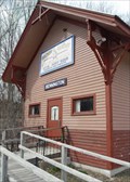 view gallery view galleryS3.9 km |  Boston & Maine Depot - Bennington, NH Boston & Maine Depot - Bennington, NH
in Train Stations/Depots The former Bennington, NH train depot is now a VFW. posted by: Telomere location: New Hampshire date approved: 04/15/2009 last visited: never |
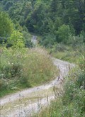
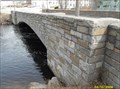 view gallery view galleryS3.9 km |  Route 47 in Historic District - Bennington, NH Route 47 in Historic District - Bennington, NH
in Arch Bridges The historic river district in Bennington, NH centers around this stone arch highway bridge. posted by: Telomere location: New Hampshire date approved: 04/15/2009 last visited: never |
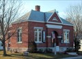 view gallery view galleryS3.9 km |  G.E.P. Dodge Library - Bennington, NH G.E.P. Dodge Library - Bennington, NH
in Libraries Dating from 1860 with a collection of 235 books, George Edward Payson Dodge donated the money in 1906 for the present library which serves the small village of Bennington, New Hampshire. posted by: silverquill location: New Hampshire date approved: 05/07/2007 last visited: never |
 view gallery view galleryS4 km | Factory Village in New Hampshire Historical Markers A sign marking a point where water generating power was, and still is, useful for industry. posted by: New England n00b location: New Hampshire date approved: 09/02/2006 last visited: 05/21/2011 |
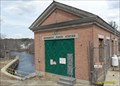 view gallery view galleryS4 km |  1923 - Monadnock Power Station - Bennington, NH 1923 - Monadnock Power Station - Bennington, NH
in Dated Buildings and Cornerstones A pair of hydro stations on the Contoocook River. posted by: Telomere location: New Hampshire date approved: 04/15/2009 last visited: never |
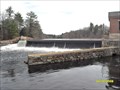 view gallery view galleryS4 km |  Monadnock Power Station - Bennington, NH Monadnock Power Station - Bennington, NH
in Water Dams A historic industrial area, centered around a natural source of hydro power. posted by: Telomere location: New Hampshire date approved: 04/15/2009 last visited: never |
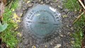
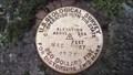
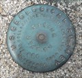 view gallery view galleryS4 km |  USGS Gaging Station 661 (Reference Mark) - Bennington, NH USGS Gaging Station 661 (Reference Mark) - Bennington, NH
in U.S. Benchmarks A disk embedded in the concrete riverwall of a Hydro Station. posted by: Telomere location: New Hampshire date approved: 04/18/2009 last visited: never |
 view gallery view gallery SE5.6 km SE5.6 km
|  Crotched Mountain - Francestown, NH Crotched Mountain - Francestown, NH
in Mountain Summits The mountain has one active and one defunct ski area. Peak elevation approx. 2050 feet. posted by: Telomere location: New Hampshire date approved: 09/15/2009 last visited: never |
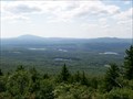 view gallery view gallerySE5.8 km |  Crotched Mountain Peak - Francestown, NH Crotched Mountain Peak - Francestown, NH
in Scenic Overlooks A view looking west/southwest over the Monadnock region of New Hampshire. posted by: Telomere location: New Hampshire date approved: 09/15/2009 last visited: never |
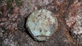
 view gallery view gallerySW6.1 km | MY2226: A 12 1935 (USC&GS/NGS, Hancock, NH) in U.S. Benchmarks A USC&GS standard bench mark disk, located in Hancock, NH.
The NGS PID# is MY2226.
The NHDOT ID# is 201-0090. posted by: NH2beers location: New Hampshire date approved: 07/11/2011 last visited: never |
 view gallery view gallerySE6.3 km |  Crotched Mountain Summit Trail - Francestown, NH Crotched Mountain Summit Trail - Francestown, NH
in Offroad Trails A former downhill ski run, now a 4x4 trail...! posted by: Telomere location: New Hampshire date approved: 09/15/2009 last visited: 08/06/2010 |
 view gallery view galleryS6.9 km | MY0842: F 11 1933 (USC&GS/NGS, Hancock, NH) in U.S. Benchmarks A USC&GS standard bench mark disk, located in Hancock, NH.
The NGS PID# is MY0842.
The NHDOT ID# is 201-0070. posted by: NH2beers location: New Hampshire date approved: 05/30/2012 last visited: never |
 view gallery view galleryS6.9 km | MY0839: 692 P (USGS, Hancock, NH) in U.S. Benchmarks A USGS mark, Located in Hancock, NH.
The NGS PID# is MY0839.
The NHDOT ID# is 201-0110. posted by: NH2beers location: New Hampshire date approved: 05/30/2012 last visited: never |
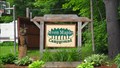 view gallery view gallerySW7.2 km |  Seven Maples Campground (Hancock, NH) Seven Maples Campground (Hancock, NH)
in Campgrounds A privately owned campground, located in Hancock, New Hampshire. posted by: NH2beers location: New Hampshire date approved: 07/13/2011 last visited: never |
 view gallery view gallery NE7.6 km NE7.6 km
| Deering, NH in City and Town Halls The Town Hall was built in 1788 as the first meeting house and served as both a church and a civic center. posted by: nomadwillie location: New Hampshire date approved: 05/29/2014 last visited: never |
 view gallery view galleryNE7.6 km | Deering Community Church - Deering NH in This Old Church Built in 1829, however the congregation was formed in 1789. posted by: nomadwillie location: New Hampshire date approved: 05/29/2014 last visited: never |
 view gallery view gallerySW8.2 km | MAC 37 1925 (USGS, Hancock, NH) in U.S. Benchmarks A USGS standard bench mark disk, located at the Hancock train depot, in Hancock, NH.
The NHDOT ID# is 201-0030. posted by: NH2beers location: New Hampshire date approved: 07/06/2011 last visited: never |
 view gallery view gallerySW8.4 km | MY2227: B 12 1935 (USC&GS/NGS, Hancock, NH) in U.S. Benchmarks A USC&GS standard bench mark disk, located in Hancock, NH.
The NGS PID# is MY2227.
The NHDOT ID# is 201-0100. posted by: NH2beers location: New Hampshire date approved: 07/14/2011 last visited: never |
 view gallery view gallerySW8.4 km | Hancock Train Station (Hancock, NH) in Train Stations/Depots This is the former train station/depot, located in Hancock, NH. posted by: NH2beers location: New Hampshire date approved: 07/13/2011 last visited: never |
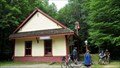
 view gallery view gallerySW8.4 km |  Hancock Historical Society - Hancock NH Hancock Historical Society - Hancock NH
in Historical Society Headquarters Historic home built in 1808/09. posted by: nomadwillie location: New Hampshire date approved: 12/19/2013 last visited: never |
 view gallery view gallerySW8.4 km |  Charles Symonds House - Hancock Village Historic District - Hancock NH Charles Symonds House - Hancock Village Historic District - Hancock NH
in NRHP Historic Districts - Contributing Buildings Historic home built in 1808/09. posted by: nomadwillie location: New Hampshire date approved: 12/15/2013 last visited: never |
|