 view gallery view gallery NE23.7 km NE23.7 km
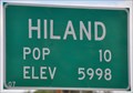
|   Hiland, Wyoming ~ Population 10 Hiland, Wyoming ~ Population 10
in Population Signs This combination Elevation/Population sign is on the northeast side of US Highway 20&26 at the eastern town limits of Hiland, Wyoming. posted by:  brwhiz brwhiz location: Wyoming date approved: 07/25/2013 last visited: never |
 view gallery view galleryNE23.7 km |  Hiland, Wyoming ~ Elevation 5998 Feet Hiland, Wyoming ~ Elevation 5998 Feet
in Elevation Signs This combination Elevation/Population sign is on the northeast side of US Highway 20&26 at the eastern town limits of Hiland, Wyoming. posted by: brwhiz location: Wyoming date approved: 07/25/2013 last visited: never |
 view gallery view galleryNE27 km |  Mama Sage - Waltman Rest Area, Wyoming Mama Sage - Waltman Rest Area, Wyoming
in Flora and Fauna Information Signs This Wyoming's Wildlife sign at the Waltman Rest Area describes the role of sage in supporting Wyoming's animal life. posted by: Tom.dog location: Wyoming date approved: 02/06/2024 last visited: never |
 view gallery view galleryNE27 km |  Waltman Rest Area ~ US Highway 20/26 Waltman Rest Area ~ US Highway 20/26
in 'You Are Here' Maps You Are Here at the Waltman Rest Area on US Highway 20/26 between Hiland and Waltman, Wyoming. posted by: brwhiz location: Wyoming date approved: 09/24/2012 last visited: 05/26/2007 |
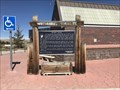
 view gallery view galleryNE27 km |  Bridger Road ~ Waltman Crossing - Waltman Rest Area, Wyoming Bridger Road ~ Waltman Crossing - Waltman Rest Area, Wyoming
in Wyoming Historical Markers This sign gives a glimpse of the history of the Bridger Road, a largely forgotten route that connected the Oregon Trail with the Montana goldfields in the 1860s. posted by: Tom.dog location: Wyoming date approved: 02/02/2024 last visited: never |
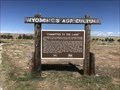 view gallery view galleryNE27 km | "Committed to the Land" - Waltman Rest Area, Wyoming in Wyoming Historical Markers This Wyoming's Agriculture sign tells of the difficult circumstances faced by homesteaders and ranchers in the Wind River Basin region during the time of its settlement. posted by: Tom.dog location: Wyoming date approved: 02/02/2024 last visited: never |
 view gallery view gallery NW28.5 km NW28.5 km
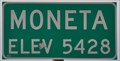
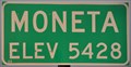
| Moneta, Wyoming ~ Elevation 5428 Feet in Elevation Signs This Elevation Sign is at the eastern town limits of Moneta, Wyoming on US Highway 20&26. posted by: brwhiz location: Wyoming date approved: 07/25/2013 last visited: never |
 view gallery view galleryNW28.8 km | Moneta, Wyoming ~ Elevation 5428 in Elevation Signs This Elevation Sign is at the western town limits of Moneta, Wyoming on US Highway 20&26. posted by: brwhiz location: Wyoming date approved: 09/24/2012 last visited: never |
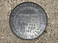
 view gallery view galleryNE31.2 km |  VS 6 Waltman-Arminto Rd. Wyoming VS 6 Waltman-Arminto Rd. Wyoming
in U.S. Benchmarks Standard USGS disc mounted in the top of a square pillar posted by: High-Plains-Drifter location: Wyoming date approved: 05/03/2010 last visited: never |
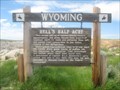 view gallery view gallery E37.2 km E37.2 km
| Hell's Half Acre in Wyoming Historical Markers Marker at Hell's Half Acre. posted by:  Biker Ozzy Biker Ozzy location: Wyoming date approved: 07/11/2010 last visited: 09/08/2023 |
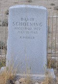 view gallery view gallery N37.8 km N37.8 km
|  David Schoening David Schoening
in Out of Place Graves This Out of Place Grave sits alone in the middle of nowhere on the north side of Badwater Road just east of Lysite, Wyoming. posted by: brwhiz location: Wyoming date approved: 08/26/2013 last visited: never |
 view gallery view galleryN38 km |  Lysite, Wyoming 82642 Lysite, Wyoming 82642
in U.S. Post Offices This Post Office is located at 25 Fremont Street in Lysite, Wyoming. posted by: brwhiz location: Wyoming date approved: 07/02/2013 last visited: never |
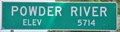 view gallery view galleryE44.9 km | Powder River, Wyoming ~ Elevation 5714 Feet in Elevation Signs This Elevation Sign is on the south side of US Highway 20&26 at the western town limits of Powder River, Wyoming. posted by: brwhiz location: Wyoming date approved: 08/01/2013 last visited: never |
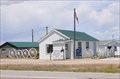
 view gallery view galleryE44.9 km |  Post Office Wagon Wheels Post Office Wagon Wheels
in Wagon Wheels Ten Wagon Wheels are used to make a decorative fence at the Post Office located at 35304 W Highway 20/26 in Powder River, Wyoming. posted by: brwhiz location: Wyoming date approved: 07/02/2013 last visited: never |
 view gallery view galleryE44.9 km | Powder River, Wyoming 82648 in U.S. Post Offices This Post Office is located at 35304 W Highway 20/26 in Powder River, Wyoming. posted by: brwhiz location: Wyoming date approved: 07/02/2013 last visited: never |
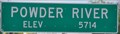 view gallery view galleryE45.5 km | Powder River, Wyoming ~ Elevation 5714 Feet in Elevation Signs This Elevation Sign is on the north side of US Highway 20&26 at the eastern town limits of Powder River, Wyoming. posted by: brwhiz location: Wyoming date approved: 08/01/2013 last visited: never |
 view gallery view gallery SE45.7 km SE45.7 km
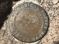
| 17 PHJ - Natrona County, Wyoming in U.S. Benchmarks A U.S. Geological Survey benchmark on the south side of County Road 321/Dry Creek Road. posted by: Tom.dog location: Wyoming date approved: 05/08/2023 last visited: never |
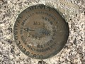
 view gallery view gallerySE46.3 km | ROCKY (NR0403) - Natrona County, Wyoming in U.S. Benchmarks This U.S. Geological Survey benchmark is set near the top of an unnamed summit in the northeastern Granite Mountains. posted by: Tom.dog location: Wyoming date approved: 05/08/2023 last visited: never |
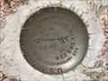
 view gallery view gallerySE46.3 km | ROCKY NO 1 - Natrona County, Wyoming in U.S. Benchmarks Reference mark 1 for USGS benchmark ROCKY. posted by: Tom.dog location: Wyoming date approved: 05/08/2023 last visited: never |
 view gallery view gallerySE46.3 km | ROCKY NO 2 - Natrona County, Wyoming in U.S. Benchmarks Reference mark 2 for USGS benchmark ROCKY. posted by: Tom.dog location: Wyoming date approved: 05/08/2023 last visited: never |
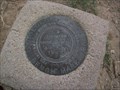
 view gallery view gallerySE47.2 km |  T30N R87W S10 S11 1/4 - Natrona County, Wyoming T30N R87W S10 S11 1/4 - Natrona County, Wyoming
in Public Land Survey Marks This GLO quarter corner marker is located just east of the crest of a ridge in the northeastern Granite Mountains. posted by: Tom.dog location: Wyoming date approved: 05/08/2023 last visited: never |
 view gallery view gallerySE48.6 km | 16 PHJ - Natrona County, Wyoming in U.S. Benchmarks A USGS benchmark set to the northeast of a bend in County Road 321 (Dry Creek Road). posted by: Tom.dog location: Wyoming date approved: 05/08/2023 last visited: never |
 view gallery view gallerySE51.8 km | 2 PHJ - Natrona County, Wyoming in U.S. Benchmarks A U.S. Geological Survey benchmark on the southwest side of County Road 321 (Dry Creek Road). posted by: Tom.dog location: Wyoming date approved: 05/08/2023 last visited: never |
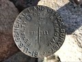
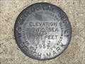
 view gallery view galleryNW55.7 km | DS 5 USGS Badwater Rd. near Bonneville/Lysite, WY in U.S. Benchmarks Standard USGS disc mounted in the top of a square pillar about 18" high. posted by: High-Plains-Drifter location: Wyoming date approved: 05/03/2010 last visited: never |
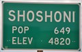 view gallery view galleryNW56.2 km | Shoshoni, Wyoming ~ Elevation 4820 Feet in Elevation Signs This combination Elevation/Population sign is on the north side of US Highway 26/Wyoming Highway 789 at the eastern town limits of Shoshoni, Wyoming. posted by: brwhiz location: Wyoming date approved: 07/25/2013 last visited: never |
|