 view gallery view gallery E21.2 km E21.2 km
|   USCGS NT0008 U 44 - 1934 USCGS NT0008 U 44 - 1934
in U.S. Benchmarks This survey disk is located just west of US 189/191, north of the junction of the two highways north of Daniel, Wyoming. With its two witness posts, and surrounded by three wooden fence posts, it is easy to spot while traveling the highway. posted by:  brwhiz brwhiz location: Wyoming date approved: 06/02/2011 last visited: never |
 view gallery view gallery SE22.9 km SE22.9 km
|  Green River or Seeds-Kee-Dee Agie Green River or Seeds-Kee-Dee Agie
in Wikipedia Entries The Green River is the largest tributary of the Colorado River. posted by: brwhiz location: Wyoming date approved: 03/12/2011 last visited: never |
 view gallery view gallery NE23.3 km NE23.3 km
|  First White Men in Sublette County First White Men in Sublette County
in First of its Kind The Astorian party were the first white men in Sublette County, Wyoming in 1811. posted by: brwhiz location: Wyoming date approved: 09/25/2012 last visited: never |
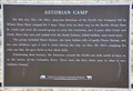 view gallery view galleryNE23.3 km |  Astorian Camp Astorian Camp
in Wyoming Historical Markers This Wyoming Historical Marker is located on the northeast side of US Highway 189/191 between Daniel and Bondurant. posted by: brwhiz location: Wyoming date approved: 09/25/2012 last visited: 04/20/2016 |
 view gallery view gallerySE23.5 km |  Daniel School ~ Daniel, Wyoming Daniel School ~ Daniel, Wyoming
in U.S. National Register of Historic Places The Daniel School (Historic District) was placed on the National Register of Historic Places on September 5, 1990. posted by: brwhiz location: Wyoming date approved: 01/08/2011 last visited: never |
 view gallery view gallerySE23.5 km |  Daniel School - Main Building - Daniel, Wyoming Daniel School - Main Building - Daniel, Wyoming
in NRHP Historic Districts - Contributing Buildings The main school building of the Daniel School is the most significant building of the Historic District. posted by: brwhiz location: Wyoming date approved: 01/08/2011 last visited: never |
 view gallery view gallerySE23.5 km |  Daniel School - Daniel, Wyoming Daniel School - Daniel, Wyoming
in Former Schools This former schoolhouse is now used for community functions. posted by: brwhiz location: Wyoming date approved: 01/08/2011 last visited: never |
 view gallery view gallerySE23.5 km | Daniel School - Daniel, Wyoming in Wikipedia Entries The Daniel School was used as a school from 1920 to 1939. It has been restored and is now used for community functions. posted by: brwhiz location: Wyoming date approved: 01/07/2011 last visited: never |
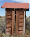 view gallery view gallerySE23.5 km | Daniel School - Girl's Privy - Daniel, Wyoming in NRHP Historic Districts - Contributing Buildings The purpose of the Girl's Privy is obvious. No running water nor indoor facilities were available when the school was in use for educational purposes. posted by: brwhiz location: Wyoming date approved: 01/08/2011 last visited: never |
 view gallery view gallerySE23.5 km | Daniel School - Boy's Privy - Daniel, Wyoming in NRHP Historic Districts - Contributing Buildings The purpose of the Boy's Privy is obvious. No running water nor indoor facilities were available when the school was in use for educational purposes. posted by: brwhiz location: Wyoming date approved: 01/08/2011 last visited: never |
 view gallery view galleryE23.7 km | 1936 GREEN RIVER RENDEZVOUS in Wyoming Historical Markers The Rendezvous had a broad meaning with the early trappers; not only was it a place to which they carried their furs and exchanged them for all sorts of commodities, such as clothing, saddles, bridles, tobacco, whiskey.... posted by: JacobBarlow location: Wyoming date approved: 04/12/2007 last visited: 06/17/2018 |
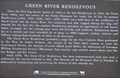 view gallery view galleryE23.7 km | Green River Rendezvous in Wyoming Historical Markers This marker, at the site of the Green River Rendezvous, replaces an older marker with entirely different wording. posted by: brwhiz location: Wyoming date approved: 03/30/2011 last visited: 06/17/2018 |
 view gallery view galleryE23.7 km | Narcissa Prentiss Whitman and Eliza Hart Spalding in Wyoming Historical Markers Two female missionaries who scored a couple of firsts in 1836. posted by: brwhiz location: Wyoming date approved: 04/06/2011 last visited: 06/17/2018 |
 view gallery view galleryE23.7 km | First White Women in Wyoming in First of its Kind Two female missionaries who scored a couple of firsts in 1836. posted by: brwhiz location: Wyoming date approved: 04/06/2011 last visited: 06/17/2018 |
 view gallery view galleryE23.7 km | First Women over Oregon Trail in First of its Kind Two female missionaries who scored a couple of firsts in 1836. posted by: brwhiz location: Wyoming date approved: 04/06/2011 last visited: 06/17/2018 |
 view gallery view gallerySE23.8 km |  Daniel, Wyoming 83115 Daniel, Wyoming 83115
in U.S. Post Offices The post office for the very small town of Daniel, Wyoming. posted by: JacobBarlow location: Wyoming date approved: 02/24/2007 last visited: 06/04/2007 |
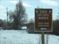
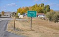
 view gallery view gallerySE23.8 km |  Daniel, Wyoming Daniel, Wyoming
in Elevation Signs This combination sign announces population and elevation of Daniel as you enter from the south on US Highway 189. posted by: brwhiz location: Wyoming date approved: 03/18/2011 last visited: never |
 view gallery view gallerySE23.8 km | Daniel, Wyoming in Wikipedia Entries Daniel is the center of the area that frontiersmen and trappers used for their rendezvous each year. posted by: brwhiz location: Wyoming date approved: 03/25/2011 last visited: never |
 view gallery view gallerySE25.6 km | THE PRAIRIE OF THE MASS in Wyoming Historical Markers A marker about two miles south of Daniel on Highway 189 reads: posted by: JacobBarlow location: Wyoming date approved: 03/25/2007 last visited: 06/17/2018 |
 view gallery view gallery N28.8 km N28.8 km
| Church of St. Hubert the Hunter and Library - Bondurant, Wyoming in Wikipedia Entries This rustic log church and library function as a community center for Bondurant. posted by: brwhiz location: Wyoming date approved: 01/08/2011 last visited: never |
 view gallery view galleryN28.8 km | Church of St. Hubert the Hunter and Library ~ Bondurant, Wyoming in U.S. National Register of Historic Places The Church of St. Hubert the Hunter and the accompanying Library serve the town of Bondurant as a social center and general meeting place as well as church and library. posted by: brwhiz location: Wyoming date approved: 01/09/2011 last visited: never |
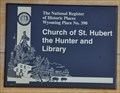 view gallery view galleryN28.8 km | Church of St. Hubert the Hunter and Library in Wyoming Historical Markers This Wyoming Historical Marker is located on the east side of US Highway 189/191 in the small village of Bondurant south of Hoback Junction. posted by: brwhiz location: Wyoming date approved: 03/22/2013 last visited: never |
 view gallery view galleryE30.1 km | Wyoming Highway ROW SUPD-16Z in U.S. Benchmarks This is a WYDOT ROW marker located quite a distance from the highway atop a small hill. posted by: brwhiz location: Wyoming date approved: 06/02/2011 last visited: never |
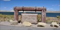
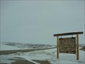
 view gallery view galleryE30.1 km |  Wind River Mountains - Bridger National Forest Wind River Mountains - Bridger National Forest
in Orientation Tables This large orientation table delineates each peak in the Wind River mountain range north and east of Pinedale, Wyoming. posted by: brwhiz location: Wyoming date approved: 04/11/2011 last visited: 07/23/2012 |
 view gallery view galleryE33.3 km |  Welcome to the Riparian Community of Duck Creek Welcome to the Riparian Community of Duck Creek
in Flora and Fauna Information Signs This Wyoming Wildlife sign is located on the north side of US Highway 191 west of Pinedale and east of Wyoming Highway 352. posted by: brwhiz location: Wyoming date approved: 09/28/2012 last visited: never |
|