 view gallery view gallery NE0 km NE0 km
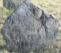
|   Hannah Drury - Wives and Mothers of 1776 - Temple, NH Hannah Drury - Wives and Mothers of 1776 - Temple, NH
in Homemade Tombstones This simply engraved chunk of native granite is located in the "Wives and Mothers of 1776" cemetery, alongside several Revolutionary War soldiers. posted by:  Telomere Telomere location: New Hampshire date approved: 12/03/2009 last visited: never |
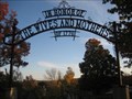 view gallery view galleryNE0.2 km |  Village Cemetery Arch - Tilton, NH Village Cemetery Arch - Tilton, NH
in Freestanding Arches This ironwork arch is found at the entrance to the old Village Cemetery in Temple, NH. posted by:  NorStar NorStar location: New Hampshire date approved: 10/28/2008 last visited: 11/05/2010 |
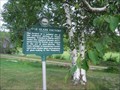
 view gallery view galleryNE0.2 km |  Village Cemetery - Temple Village Cemetery - Temple
in New Hampshire Historical Markers A town marker for the Temple Village Cemetery posted by: New England n00b location: New Hampshire date approved: 08/23/2006 last visited: 11/05/2010 |
 view gallery view galleryNE0.2 km | Temple Glass Factory - Sharon in New Hampshire Historical Markers An official marker describing a glass factory in old Temple township with some interesting historical connections. posted by: New England n00b location: New Hampshire date approved: 08/23/2006 last visited: 11/29/2009 |
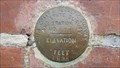 view gallery view gallery S0.2 km S0.2 km
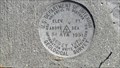
|  G 52 1935 (USC&GS&SS, Temple, NH) G 52 1935 (USC&GS&SS, Temple, NH)
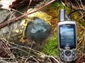
in U.S. Benchmarks A USC&GS&SS standard disk, located on the old Temple School, in Temple, NH.
The NHDOT ID# is 445-0020. posted by: NH2beers location: New Hampshire date approved: 08/05/2011 last visited: never |
 view gallery view gallery N0.2 km N0.2 km
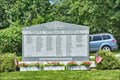
|  Temple Veterans Memorial - Temple NH Temple Veterans Memorial - Temple NH
in Non-Specific Veteran Memorials Located on a green in front of the old Temple Town Hall. posted by: nomadwillie location: New Hampshire date approved: 07/20/2017 last visited: never |
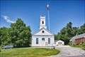 view gallery view galleryN0.2 km |  Temple, NH (former) Temple, NH (former)
in City and Town Halls In 1889 the Town of Temple purchased Union Hall as their Town Hall, allowing Miller Grange access to the building. posted by: nomadwillie location: New Hampshire date approved: 07/20/2017 last visited: never |
 view gallery view galleryN0.2 km |  Temple Town Hall - Temple NH Temple Town Hall - Temple NH
in U.S. National Register of Historic Places Built in 1842 as a meeting house (Union Hall) the Temple Town Hall was purchased by the Miller Grange in 1875 to server the purposes of a Grange building. posted by: nomadwillie location: New Hampshire date approved: 07/20/2017 last visited: never |
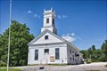 view gallery view galleryN0.2 km |  Union Hall - Temple Town Hall - Temple NH Union Hall - Temple Town Hall - Temple NH
in This Old Church Built in 1842 as a meeting house (Union Hall) the Temple Town Hall was purchased by the Miller Grange in 1875 to server the purposes of a Grange building. posted by: nomadwillie location: New Hampshire date approved: 07/20/2017 last visited: never |
 view gallery view galleryN0.2 km |  Temple Town Hall - Temple NH Temple Town Hall - Temple NH
in Wikipedia Entries Built in 1842 as a meeting house (Union Hall) the Temple Town Hall was purchased by the Miller Grange in 1875 to server the purposes of a Grange building. posted by: nomadwillie location: New Hampshire date approved: 07/20/2017 last visited: never |
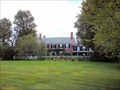
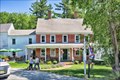 view gallery view galleryN0.2 km | Birchwood Inn - Temple NH in U.S. National Register of Historic Places The Birchwood Inn dates back to 1775, however the present day brick building was probably built around 1800. posted by: nomadwillie location: New Hampshire date approved: 07/20/2017 last visited: never |
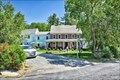 view gallery view galleryN0.2 km | Birchwood Inn - Temple NH in Wikipedia Entries The Birchwood Inn dates back to 1775, however the present day brick building was probably built around 1800. posted by: nomadwillie location: New Hampshire date approved: 07/20/2017 last visited: never |
 view gallery view galleryN0.2 km |  Birchwood Inn - Temple NH Birchwood Inn - Temple NH
in Pubs and Inns The Birchwood Inn dates back to 1775, however the present day brick building was probably built around 1800. posted by: nomadwillie location: New Hampshire date approved: 07/20/2017 last visited: never |
 view gallery view galleryN0.2 km |  Birchwood Inn - Temple NH Birchwood Inn - Temple NH
in Antique Hotels The Birchwood Inn dates back to 1775, however the present day brick building was probably built around 1800. posted by: nomadwillie location: New Hampshire date approved: 07/20/2017 last visited: never |
 view gallery view gallery E1.6 km E1.6 km
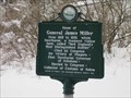
| General James Miller in New Hampshire Historical Markers A historical marker in the Town of Temple, New Hampshire about the Home of General James Miller, New England's most distinguished soldier. posted by: king.hubi location: New Hampshire date approved: 01/26/2010 last visited: never |
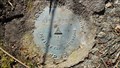
 view gallery view galleryN2.7 km | 82 ATA RESET 1979 (USDI, Temple, NH) in U.S. Benchmarks A USDI disk, located in Temple, NH.
The NHDOT ID# is 445-0060. posted by: NH2beers location: New Hampshire date approved: 03/01/2012 last visited: never |
 view gallery view gallery W2.7 km W2.7 km
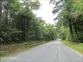
|  Spofford Gap - Temple, NH Spofford Gap - Temple, NH
in Named Mountain Gaps Spofford Gap is a gorge separating Temple Mountain from other mountains to the southeast and traversed by West Street from Temple to Sharon, NH. posted by: NorStar location: New Hampshire date approved: 09/10/2012 last visited: 09/22/2013 |
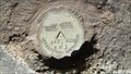
 view gallery view galleryNE3.1 km | 445 0110 in U.S. Benchmarks A New Hampshire Department of Public Works Highways (NHDPH, now NHDOT) benchmark disk located on the south side of NH Route 101 in Temple, NH. posted by: Jay-7 location: New Hampshire date approved: 02/28/2012 last visited: 02/26/2012 |
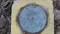
 view gallery view galleryNE3.1 km | 445 0110 RM 2 (NHDPW&H, Temple, NH) in U.S. Benchmarks One of two reference marks relative to NHDOT station 445 0110, located in Temple, NH. posted by: NH2beers location: New Hampshire date approved: 03/14/2012 last visited: never |
 view gallery view galleryNE3.1 km | 445 0110 RM1 (NHDPW&H, Temple, NH) in U.S. Benchmarks One of two reference marks relative to NHDOT station 445 0110, located in Temple, NH. posted by: NH2beers location: New Hampshire date approved: 03/14/2012 last visited: never |
 view gallery view galleryNE3.5 km | S 29 (NHDPW&H, Wilton, NH) in U.S. Benchmarks A NHDPW&H disk, located in Wilton, NH.
It is an azimuth mark for 445 0110 (MY5425).
The NHDOT ID# is 485-0140. posted by: NH2beers location: New Hampshire date approved: 03/01/2012 last visited: never |
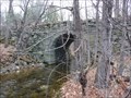 view gallery view galleryNE4.3 km |  County Farm Bridge - Wilton NH County Farm Bridge - Wilton NH
in Stone Bridges Country Farm Bridge is located in Wilton NH on Old Country Farm Rd and was listed on the National Register of Historic Places in 1981.
posted by: nomadwillie location: New Hampshire date approved: 10/22/2009 last visited: 11/29/2008 |
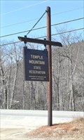 view gallery view gallery NW4.5 km NW4.5 km
|  Wapack Trail - Route 101 / Temple Reservation trailhead Wapack Trail - Route 101 / Temple Reservation trailhead
in Hiking and walking trailheads The former Temple Ski Area is now a preserve, with parking and access to the Wapack trail. posted by: Telomere location: New Hampshire date approved: 04/02/2009 last visited: 11/20/2010 |
 view gallery view galleryNE5 km | Whiting, Oliver, Homestead - Wilton, NH in U.S. National Register of Historic Places Built in the Federal, Gothic Revival style posted by: silverquill location: New Hampshire date approved: 04/19/2007 last visited: 11/29/2008 |
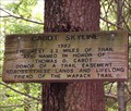 view gallery view galleryW5 km | Wapack trail - Cabot Skyline Trailhead - Sharon, NH in Hiking and walking trailheads Easily accessible trailhead, with parking; and two segments of the Wapack trail. posted by: Telomere location: New Hampshire date approved: 05/18/2009 last visited: 10/23/2020 |
|