 view gallery view gallery SE23.2 km SE23.2 km
|   Arcalis 91 Arcalis 91
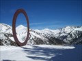
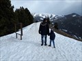
in Abstract Public Sculptures Arcalís 91, un gigantesco aro rojo con doce metros de diámetro, que se eleva en la estación de esquí de Vallnord (Sector de Arcalis). posted by:  falaubabau falaubabau location: Andorra date approved: 04/06/2010 last visited: 06/30/2017 |
 view gallery view gallery NW23.3 km NW23.3 km
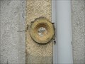
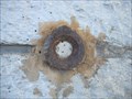
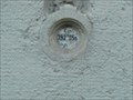
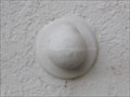
|  Benchmark E.C.O3P3 - 9 - Eycheil Benchmark E.C.O3P3 - 9 - Eycheil
in French Benchmarks Localisation : AU NO 16, ROUTE DES PYRENEES
Partie support : MUR DE FACADE SUD-OUEST DE LA PARTIE CENTRALE, FACE ROUTE
Altitude : 408,025 m posted by:  eolas eolas location: Occitanie, France date approved: 02/21/2013 last visited: never |
 view gallery view galleryNW23.7 km | Benchmark E.C.O3P3 - 7 - Saint-Girons in French Benchmarks Localisation : A LA PLAINE D'EYCHEIL, AU NO 72, AVENUE DE LA RESISTANCE
Altitude : 405,245 m posted by: eolas location: Occitanie, France date approved: 02/21/2013 last visited: never |
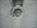
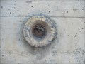
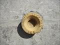
 view gallery view galleryNW24 km | Benchmark E.C.O3P3 - 6 - D.618 - Saint-Girons in French Benchmarks Type : Repère cylindrique
Localisation : Plaine d'Eycheil, 61 Avenue de la Résitance
Partie support : Soubassement du mur pignon sud-ouest, face route
Altitude : 403.25 posted by: eolas location: Occitanie, France date approved: 02/20/2013 last visited: never |
 view gallery view gallery S24.1 km S24.1 km
|  En Roc del Quer - Canillo, Andorra En Roc del Quer - Canillo, Andorra
in Framed Views One frame in this place posted by: Ariberna location: Andorra date approved: 09/25/2020 last visited: 11/17/2022 |
 view gallery view gallery NE24.1 km NE24.1 km
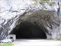
| ") La grotte de Bédeilhac (Ariège) - France La grotte de Bédeilhac (Ariège) - France
in Cave Entrances (Natural) [FR] La grotte de Bédeilhac est une vaste grotte ornée située sur la commune de Bédeilhac-et-Aynat en Ariège. [EN] The caves of the Ariège have some of the finest examples of paleolithic paintings and artifacts anywhere in the world. posted by: RakeInTheCache location: Occitanie, France date approved: 05/26/2012 last visited: 02/06/2020 |
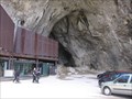 view gallery view gallery E24.3 km E24.3 km
| La grotte de Niaux (Ariège) - France in Cave Entrances (Natural) [FR] La grotte de Niaux est une grotte ornée du Paléolithique supérieur ayant livré de nombreuses figurations pariétales magdaléniennes. [EN] Like Lascaux, La grotte de Niaux, contains many prehistoric paintings of superior quality. posted by: RakeInTheCache location: Occitanie, France date approved: 05/26/2012 last visited: 02/06/2020 |
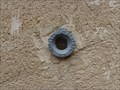 view gallery view galleryE24.5 km | Benchmarck église d'Arquizat in French Benchmarks Repère de nivellement en Ariège posted by: yohaeva location: Occitanie, France date approved: 08/28/2014 last visited: 02/06/2020 |
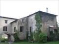 view gallery view galleryE24.6 km |  Domaine Fournié - Tarascon-sur-Ariège, France Domaine Fournié - Tarascon-sur-Ariège, France
in Bed and Breakfast [FR] La famille Marie vous ouvre les portes de sa propriété du 17e siecle, au parc centenaire et bois classé. [EN] The Marie family welcomes you to their 17th century property, where you can unwind in the shade of the hundred year old trees. posted by: RakeInTheCache location: Occitanie, France date approved: 05/20/2012 last visited: 02/06/2020 |
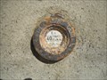
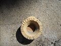
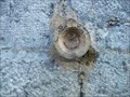
 view gallery view galleryNW25.1 km | Benchmark E.C.P3 - 3 - D.117 - Saint-Girons in French Benchmarks Type : repère cylindrique nivellement
Localisation : pont D117
Altitude : 391.45 posted by: eolas location: Occitanie, France date approved: 02/20/2013 last visited: never |
 view gallery view galleryNW25.3 km | Benchmark E.C.O3P3 - 4 - D.618 - Saint-Girons in French Benchmarks Type : Repère cylindrique de nivellement
Localisation : à 15 mètres au sud-est du carrefour avec la rue Morinière
Altitude : 398.94 posted by: eolas location: Occitanie, France date approved: 02/20/2013 last visited: never |
 view gallery view galleryNW25.4 km | Benchmark E.C.O3P3 - 2 - Saint-Girons in French Benchmarks Localisation : AU CARREFOUR AVEC LE BOULEVARD PEYREVIDOL
Partie support : MUR DE FACADE SUD-OUEST, FACE RUE DESBIAUX
Altitude : 392,194 m posted by: eolas location: Occitanie, France date approved: 02/20/2013 last visited: never |
 view gallery view galleryNW25.6 km | Benchmark E.C.O3P3 - 3 - Saint-Girons in French Benchmarks Voie suivie : AVENUE GALLIENI (D.618) - 24
Partie support : SOUBASSEMENT DU MUR DE FACADE EST, FACE AVENUE
Altitude : 392.34 posted by: eolas location: Occitanie, France date approved: 02/20/2013 last visited: never |
 view gallery view galleryNW25.6 km | Benchmark E.C.O3P3 - 1 - Saint-Girons in French Benchmarks Support : ECOLE PAUL SAINT-ALARY
Partie support : SOUBASSEMENT DU MUR DE FACADE SUD-OUEST, FACE PLACE
Altitude : 391,825 m posted by: eolas location: Occitanie, France date approved: 02/20/2013 last visited: never |
 view gallery view galleryNW25.7 km |  Carrière de marbre, Aubert Carrière de marbre, Aubert
in Active Quarries Petite carrière située à Aubert qui produit du marbre très prestigieux, nommé "Grand Antique". posted by: 09Naturel location: Occitanie, France date approved: 07/01/2018 last visited: 02/24/2020 |
 view gallery view galleryNW25.7 km | Benchmark L'église de Saint-Girons in French Benchmarks Localisation : A 190 M AU SUD DU CARREFOUR DE LA D.117 ET DE LA RUE DU MARCHE, PLACE DE VERDUN
Partie support : ABOUT DU 2EME CONTREFORT DU TRANSEPT GAUCHE A PARTIR DU CHOEUR, FACE A LA
PLACE, FACE NORD-OUEST
Altitude: 390.818 m. posted by: eolas location: Occitanie, France date approved: 02/20/2013 last visited: never |
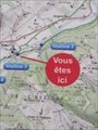 view gallery view galleryNW25.7 km |  "Vous êtes ici" - Station 3 du sentier Vél'eau, Aubert "Vous êtes ici" - Station 3 du sentier Vél'eau, Aubert
in 'You Are Here' Maps "Vous êtes ici" sur un panneau explicatif du sentier Vél'eau, station 3, Aubert. posted by: 09Naturel location: Occitanie, France date approved: 06/29/2018 last visited: 06/28/2018 |
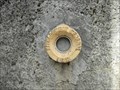
 view gallery view galleryNW25.9 km | Benchmark - ANCIEN COLLEGE D'ENSEIGNEMENT TECHNIQUE in French Benchmarks Localisation : A SAINT-GIRONS, AU NO 28 DE L'AVENUE RENE PLAISANT
Support : MAISON (ANCIEN COLLEGE D'ENSEIGNEMENT TECHNIQUE)
Altitude : 390,435 m posted by: eolas location: Occitanie, France date approved: 02/21/2013 last visited: never |
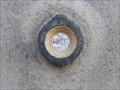
 view gallery view galleryNW25.9 km | Benchmark Pont neuf - Saint-Girons in French Benchmarks Localisation : A L'ANGLE SUD-OUEST DU SQUARE BALAGUE
Support : PONT SUR LE SALAT
Altitude : 390,329 m posted by: eolas location: Occitanie, France date approved: 02/21/2013 last visited: never |
 view gallery view galleryNW25.9 km | Benchmark - Eglise de Lédar in French Benchmarks Localisation : EGLISE
Partie support : MUR DE FACADE SUD-EST DE LA NEF, FACE ROUTE
Altitude : 400,198 m posted by: eolas location: Occitanie, France date approved: 02/20/2013 last visited: never |
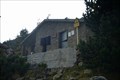 view gallery view gallerySE26.1 km |  Refugi de Les Fonts - La Massana, Andorra Refugi de Les Fonts - La Massana, Andorra
in Remote Backcountry Shelters El refugi de les Fonts és un refugi de muntanya de la Parròquia de La Massana (Andorra) a 2.200 m d'altitud i situat a la Percanela sota el Pic de Les Fonts entre la Coruvilla i Montmantell. posted by: SastRe.O location: Andorra date approved: 11/21/2018 last visited: never |
 view gallery view galleryNW26.1 km | Benchmark - E.C.N3O3 - 37 - Saint-Girons in French Benchmarks Localisation : AU QUARTIER DE LEDAR, AU NO 19, AVENUE DU MARECHAL FOCH
Partie support : SOUBASSEMENT DU MUR PIGNON NORD-OUEST, FACE ROUTE
Altitude : 394,549 m posted by: eolas location: Occitanie, France date approved: 02/20/2013 last visited: never |
 view gallery view galleryNW26.1 km | Benchmark - E.C.N3O3 - 36 - Saint-Girons in French Benchmarks Localisation : AVENUE DU MARECHAL FOCH (D.618)
AU QUARTIER LEDAR, AU NO 43, AVENUE DU MARECHAL FOCH
Altitude : 397,006 m posted by: eolas location: Occitanie, France date approved: 02/20/2013 last visited: never |
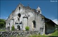 view gallery view galleryNW26.1 km |  Church of Our Lady in Luzenac / L'Eglise de Notre-Dame-de-Luzenac-de-Moulis (Ariege, France) Church of Our Lady in Luzenac / L'Eglise de Notre-Dame-de-Luzenac-de-Moulis (Ariege, France)
in Medieval Churches Interesting and in shape very unusual Romanesque church of Our Lady (Eglise de Notre-Dame) you can find in Luzenac, small village in Ariege department in south-western France... posted by: Dorcadion Team location: France date approved: 07/01/2009 last visited: 03/03/2018 |
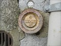
 view gallery view galleryNW26.2 km | Benchmark - L'ancienne gare - Saint-Girons in French Benchmarks Type : REPERE BOULE
Localisation : A 50 M A L'OUEST DE LA D.117
Support : GARE DE SAINT-GIRONS
Partie support : MUR DE FACADE DE L'AILE NORD, FACE VOIE FERREE
*** Ce repère n'a pas été observé par l' I.G.N.
Altitude : 391,720 m posted by: eolas location: Occitanie, France date approved: 02/20/2013 last visited: never |
|